World Heritage Identification Number: 1339
World Heritage since: 2010
Category: Cultural Heritage
WHE Type: Memorial Sites
Transboundary Heritage: No
Endangered Heritage: No
Country: 🇲🇭 Marshall Islands
Continent: Oceania
UNESCO World Region: Asia and the Pacific
Map
Bikini Atoll Nuclear Test Site: A Symbol of the Dawn of the Nuclear Age
The Bikini Atoll Nuclear Test Site, located in the Marshall Islands, stands as a poignant reminder of the advent of the nuclear era. Inscribed on the UNESCO World Heritage List in 2010, this atoll bears witness to the profound impact of nuclear testing during the latter half of the 20th century.
More to come…UNESCO Description of the World Heritage Site
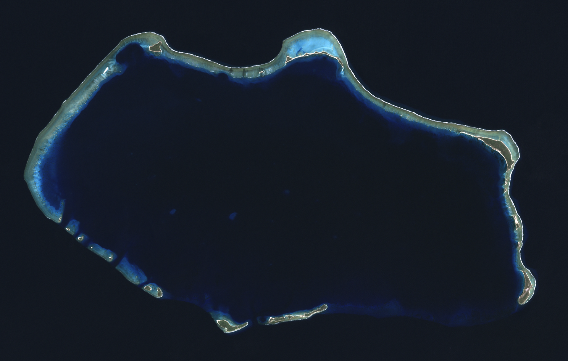
In the wake of World War II, in a move closely related to the beginnings of the Cold War, the United States of America decided to resume nuclear testing in the Pacific Ocean, on Bikini Atoll in the Marshall archipelago. After the displacement of the local inhabitants, 67 nuclear tests were carried out from 1946 to 1958, including the explosion of the first H-bomb (1952). Bikini Atoll has conserved direct tangible evidence that is highly significant in conveying the power of the nuclear tests, i.e. the sunken ships sent to the bottom of the lagoon by the tests in 1946 and the gigantic Bravo crater. Equivalent to 7,000 times the force of the Hiroshima bomb, the tests had major consequences on the geology and natural environment of Bikini Atoll and on the health of those who were exposed to radiation. Through its history, the atoll symbolises the dawn of the nuclear age, despite its paradoxical image of peace and of earthly paradise. This is the first site from the Marshall Islands to be inscribed on the World Heritage List.
UNESCO Justification of the World Heritage Site
Criterion (iv): Bikini Atoll is an outstanding example of a nuclear test site. It has many military remains and characteristic terrestrial and underwater landscape elements. It is tangible testimony of the birth of the Cold War and it bears testimony to the race to develop increasingly powerful nuclear weapons. In the wake of the Hiroshima and Nagasaki bombs, the Bikini Atoll site confirmed that mankind was entering a nuclear era. It also bears witness to the consequences of the nuclear tests on the civil populations of Bikini and the Marshall Islands, in terms of population displacement and public-health issues.
Criterion (vi): The ideas and beliefs associated with the Bikini nuclear test site, and more generally with the escalation of military power which characterized the Cold War, are of international significance. These events gave rise to a large number of international movements advocating nuclear disarmament; they gave rise to powerful symbols and to many images associated with the “nuclear era”, which characterized the second part of the 20th century.
Encyclopedia Record: Bikini Atoll
Bikini Atoll, known as Eschscholtz Atoll between the 19th century and 1946, is a coral reef in the Marshall Islands consisting of 23 islands surrounding a 229.4-square-mile (594.1 km2) central lagoon. The atoll is at the northern end of the Ralik Chain, approximately 530 miles (850 km) northwest of the capital Majuro.Additional Site Details
Area: 73,500 hectares
Number of Components: 1
(vi) — Directly associated with events or living traditions
Coordinates: 11.6 , 165.3805555556
Image
NASA, Public domain
