World Heritage Identification Number: 1325
World Heritage since: 2010
Category: Natural Heritage
WHE Type: Protected Areas & National Parks
Transboundary Heritage: No
Endangered Heritage: No
Country: 🇰🇮 Kiribati
Continent: Oceania
UNESCO World Region: Asia and the Pacific
Map
The Phoenix Islands Protected Area: A Giant Sanctuary in the Central Pacific
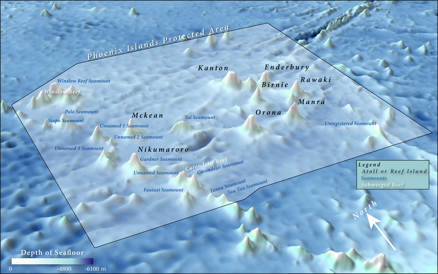
The Phoenix Islands Protected Area (PIPA) is a vast expanse of marine and terrestrial habitats situated in the heart of the Southern Pacific Ocean. Encompassing the Phoenix Island Group, one of three island groups in Kiribati, this protected area represents the largest designated Marine Protected Area (MPA) globally, spanning over 408,250 square kilometers. Established in 2010, PIPA was the first site in Kiribati to be inscribed on the prestigious UNESCO World Heritage List.
More to come…UNESCO Description of the World Heritage Site
The Phoenix Island Protected Area (PIPA) is a 408,250 sq.km expanse of marine and terrestrial habitats in the Southern Pacific Ocean. The property encompasses the Phoenix Island Group, one of three island groups in Kiribati, and is the largest designated Marine Protected Area in the world. PIPA conserves one of the world's largest intact oceanic coral archipelago ecosystems, together with 14 known underwater sea mounts (presumed to be extinct volcanoes) and other deep-sea habitats. The area contains approximately 800 known species of fauna, including about 200 coral species, 500 fish species, 18 marine mammals and 44 bird species. The structure and functioning of PIPA's ecosystems illustrates its pristine nature and importance as a migration route and reservoir. This is the first site in Kiribati to be inscribed on the World Heritage List.
UNESCO Justification of the World Heritage Site
Criterion (vii): Phoenix Islands Protected Area, an oceanic wilderness, is sufficiently remote and inhospitable to human colonisation as to be exceptional in terms of the minimal evidence of the impacts of human activities both on the atolls and in the adjacent seas. The Phoenix Islands Protected Area is a very large protected area, a vast wilderness domain where nature prevails and man is but an occasional visitor. The property is distinguished by containing a large suite of seamounts complete with a broad expanse of contextual abyssal plain with a natural phenomenon of global significance. The essentially pristine environment, outstanding underwater clarity, the spectacle of large groups of charismatic aquatic animals (e.g. bumphead parrotfish, Napolean wrasse, surgeonfishes, parrotfishes, groupers, maori wrasse, sharks, turtles, dolphins, manta rays, giant clams) in quantities rarely found elsewhere in the world, aesthetically outstanding coral reef features (e.g. giant clams, large coral heads) together with the spectacle of huge concentrations of seabirds on remote atolls, makes of this property a truly kaleidoscopic natural oceanscape exhibiting exceptional natural beauty of global significance.
Criterion (ix): With its rich biota, as a known breeding site for numerous nomadic, migratory and pelagic marine and terrestrial species, and the known and predicted high level of biodiversity and endemicity associated with these isolated mid-ocean atolls, submerged reefs and seamounts, Phoenix Islands Protected Area makes an outstanding contribution to ongoing ecological and biological processes in the evolution and development of global marine ecosystems and communities of plants and animals. Phoenix Islands Protected Area has exceptional value as a natural laboratory for the study and understanding of the significant ongoing ecological and biological processes in the evolution and development of marine ecosystems of the Pacific, the world's largest ocean, indeed all oceans. This property is of crucial scientific importance in identifying and monitoring the processes of sea level change, growth rates and age of reefs and reef builders, (both geologically and historically) and in evaluating effects from climate change.
Encyclopedia Record: Phoenix Islands Protected Area
The Phoenix Islands Protected Area (PIPA) is located in the Republic of Kiribati, an ocean nation in the central Pacific approximately midway between Australia and Hawaii. PIPA constitutes 11.34% of Kiribati's exclusive economic zone (EEZ), and with a size of 408,250 km2 (157,630 sq mi), it is one of the largest marine protected areas (MPA) and one of the largest protected areas of any type on Earth. The PIPA was also designated as the world's largest and deepest UNESCO World Heritage Site in 2010.Additional Site Details
Area: 40,825,000 hectares
Number of Components: 1
(ix) — Outstanding example representing ecological and biological processes
Coordinates: -3.864454 , -172.650203
IUCN World Heritage Outlook
The 2025 Conservation Outlook on Phoenix Islands Protected Area reports the following assessment:
Source: International Union for Conservation of Nature (IUCN) · View assessment
Image
© Kerry Lagueux, New England Aquarium., CC BY-SA 3.0 Resized from original. (This derivative is under the same CC BY-SA license.)
