World Heritage Identification Number: 447
World Heritage since: 1987
Category: Mixed Cultural Heritage and Natural Heritage
WHE Type: Protected Areas & National Parks
Transboundary Heritage: No
Endangered Heritage: No
Country: 🇦🇺 Australia
Continent: Oceania
UNESCO World Region: Asia and the Pacific
Map
Uluṟu–Kata Tjuṯa National Park: A Cultural and Natural Landscape of Timeless Significance
Uluṟu-Kata Tjuṯa National Park, previously known as Ayers Rock–Mount Olga National Park, is a protected area situated in the heart of Australia's Red Centre, approximately 1,943 kilometers (1,207 miles) south of Darwin and 440 kilometers (270 miles) west of Alice Springs. Covering an area of 1,326 square kilometers (512 square miles), this national park is renowned for its breathtaking geological formations that dominate the expansive red sandy plains of central Australia.
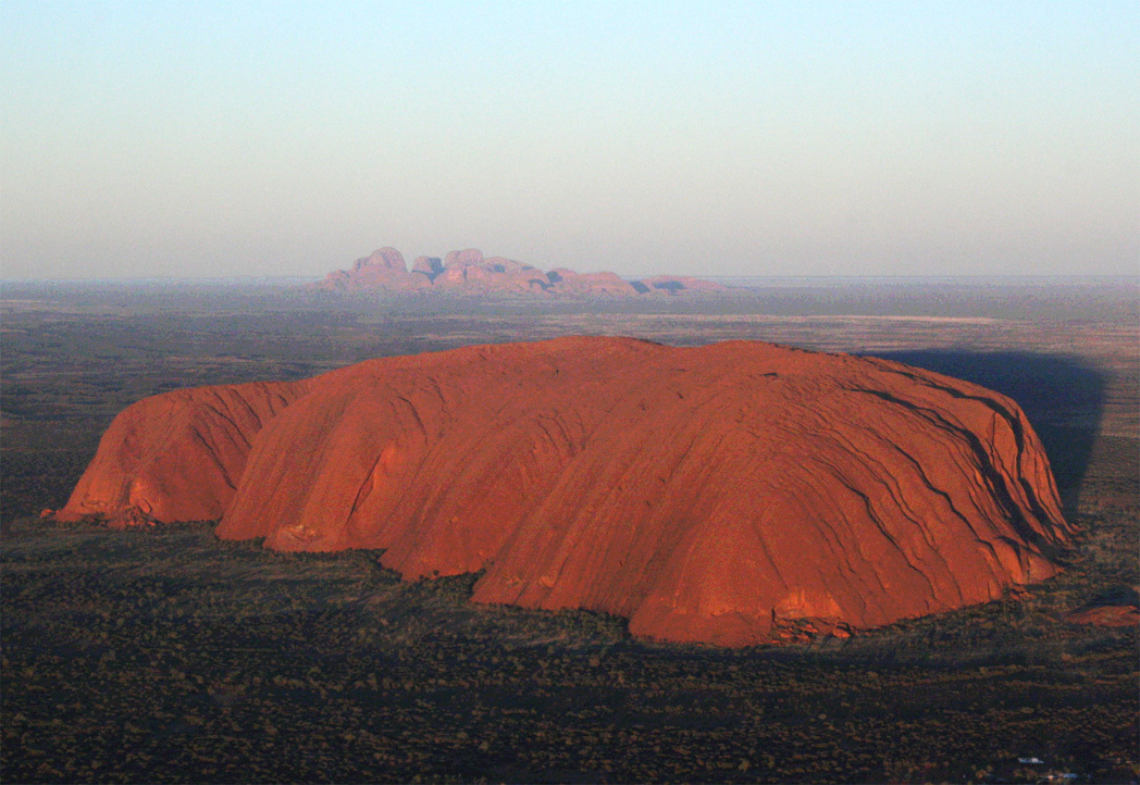
The park's most iconic feature is Uluru, an immense monolith rising majestically from the desert floor. With a height of 348 meters (1,142 feet) above ground level and a base circumference of around 9.4 kilometers (5.8 miles), Uluru is one of the most recognizable Australian landmarks and one of the world's largest monoliths. Uluru continues below the surface as part of a larger rock formation, though the exact extent of its underground portion is not known.
Located about 32 kilometers west of Uluru lies Kata Tjuta, a group of 36 weathered domes that stand as a striking contrast to the solitary grandeur of Uluru. Kata Tjuta means "many heads" in the language of the traditional Anangu people. These sacred rock formations, formerly known as the Olgas, are composed of conglomerate, a sedimentary rock made up of pebbles and larger fragments of other rocks cemented together.
Beyond their physical beauty, these geological wonders hold deep spiritual significance for the Anangu Aboriginal people, who have been the traditional owners of the region for tens of thousands of years. The Anangu believe that Uluru and Kata Tjuta are sacred sites, containing the ancestral spirits of their ancestors. Their stories, passed down through generations, explain the formation of these landmarks and provide guidance for living harmoniously with the land.
In 1987, Uluṟu–Kata Tjuta National Park was inscribed on the UNESCO World Heritage List for its outstanding natural values. In 1994, its cultural significance was also recognized, making it one of the rare UNESCO sites listed for both natural and cultural values. The site's natural values include its geological features, unique vegetation communities, and the diverse wildlife that thrive within its boundaries. The park supports a variety of flora, including spinifex grasslands, mulga woodlands, and acacia shrublands, which provide habitat for a range of fauna, such as kangaroos, wallabies, dingoes, and various bird species.
Visitors to Uluṟu-Kata Tjuta National Park can embark on guided walks led by Anangu guides, offering insights into the park's cultural and natural history. Walking trails lead to the bases of Uluru and Kata Tjuta, allowing visitors to appreciate the sheer scale and beauty of these ancient landforms. Sunrise and sunset tours offer unparalleled opportunities to witness the dramatic changes in light and color that transform these landscapes throughout the day.
Ultimately, Uluṟu-Kata Tjuta National Park stands as a testament to the enduring connection between the Anangu people and their ancestral lands. Its geological wonders, rich cultural heritage, and unique ecosystem make it a must-visit destination for anyone seeking to experience the essence of Australia's Red Centre.
UNESCO Description of the World Heritage Site
This park, formerly called Uluru (Ayers Rock – Mount Olga) National Park, features spectacular geological formations that dominate the vast red sandy plain of central Australia. Uluru, an immense monolith, and Kata Tjuta, the rock domes located west of Uluru, form part of the traditional belief system of one of the oldest human societies in the world. The traditional owners of Uluru-Kata Tjuta are the Anangu Aboriginal people.
UNESCO Justification of the World Heritage Site
Criterion (v): The cultural landscape of Uluru-Kata Tjuta National Park is an outstanding living reflection of indigenous Anangu traditional hunting, gathering and other practices of great antiquity that have created an intimate relationship between people and their environment.
Criterion (vi): The cultural landscape is of outstanding significance for the way it is perceived as the creation of Mala, Lungkata, Itjaritjari, Liru and Kuniya - these are heroic ancestral beings of the Tjukurpa. The landscape isread as a text specifying the relationship between the land and its Indigenous inhabitants, as laid down by the Tjukurpa. The monoliths of Uluru and Kata Tjuta are seen as living proof of the heroes' actions and their very being.
Criterion (vii): The huge monolith of Uluru and multiple rock domes of Kata Tjuta (32 kilometres to the west of Uluru) have outstanding scenic grandeur, contrasting with each other and the surrounding flat sand plains. The monolithic nature of Uluru is emphasised by sheer, steep sides rising abruptly from the surrounding plain, with little or no vegetation to obscure the silhouette. The exceptional natural beauty of the Uluru-Kata Tjuta National Park landscape is also of cultural importance to Anangu.
Criterion (viii): The inselbergs (steep-sided isolated hills rising abruptly from the earth) of Uluru and Kata Tjuta are outstanding examples of tectonic, geochemical and geomorphic processes. Uluru and Kata Tjuta reflect the age, and relatively stable nature, of the Australian continent. Uluru and Kata-Tjuta demonstrate ongoing geological processes of remarkable interest. The sides of Uluru are marked by a number of unusual features which can be ascribed to differing processes of erosion. For example, the colossal geological feature described as Ngaltawata, a ceremonial pole associated with Mala Tjukurpa, is ascribed to sheeting of rock parallel to the existing surface. During rain periods, the runoff from Uluru cascades down the fissures forming waterfalls, some up to 100 metres high. Caves at the base of Uluru are formed by a widespread arid zone process of granular disintegration known as cavernous weathering.
Encyclopedia Record: Uluṟu-Kata Tjuṯa National Park
Uluṟu-Kata Tjuṯa National Park is a protected area in the Northern Territory of Australia. The park is home to both Uluru and Kata Tjuta. It is located 1,943 kilometres (1,207 mi) south of Darwin by road and 440 kilometres (270 mi) south-west of Alice Springs along the Stuart and Lasseter Highways. The park covers 1,326 square kilometres (512 sq mi) and includes the features it is named after: Uluru and, 40 kilometres (25 mi) to its west, Kata Tjuta. The location is listed as a UNESCO World Heritage Site for natural and cultural landscape.Additional Site Details
Area: 132,566 hectares
Number of Components: 1
(vi) — Directly associated with events or living traditions
(vii) — Contains superlative natural phenomena or beauty
(viii) — Outstanding example representing major earth stages
Coordinates: -25.33333333 , 131
IUCN World Heritage Outlook
The 2025 Conservation Outlook on Uluṟu-Kata Tjuṯa National Park reports the following assessment:
Source: International Union for Conservation of Nature (IUCN) · View assessment