World Heritage Identification Number: 181
World Heritage since: 1982
Category: Mixed Cultural Heritage and Natural Heritage
WHE Type: Protected Areas & National Parks
Transboundary Heritage: No
Endangered Heritage: No
Country: 🇦🇺 Australia
Continent: Oceania
UNESCO World Region: Asia and the Pacific
Map
Tasmanian Wilderness: A Unique Expansive Temperate Rainforest
The Tasmanian Wilderness World Heritage Area (TWWHA) is a remarkable testament to the natural beauty and biodiversity of Tasmania, Australia. This vast conservation area, spanning over 15,800 square kilometers or approximately 25 percent of Tasmania's total area, was inscribed as a UNESCO World Heritage Site in 1982.
The TWWHA is situated within a region that has undergone significant glacial activity, resulting in the formation of steep gorges and valleys. This geographical diversity, coupled with the mild temperate climate, creates an ideal habitat for various flora and fauna species. The area is particularly renowned for its extensive temperate rainforests, which are among the last remaining expanses of this unique ecosystem worldwide.
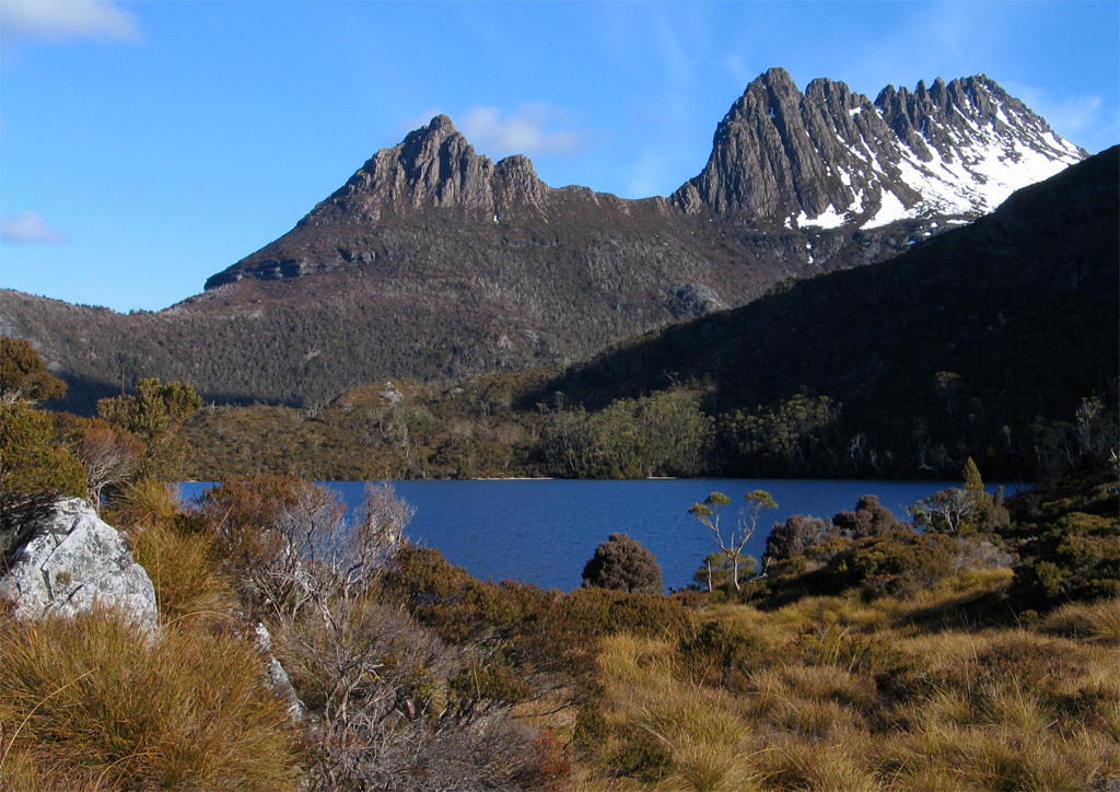
The TWWHA encompasses several national parks and reserves, including the Cradle Mountain-Lake St Clair National Park, the Franklin-Gordon Wild Rivers National Park, the Southwest National Park, Mount Field National Park, Hartz Mountains National Park, Mole Creek Karst National Park, and the Walls of Jerusalem National Park. These protected areas offer visitors a chance to experience the pristine wilderness, with opportunities for hiking, camping, and wildlife spotting.
One of the most notable features of the TWWHA is the abundance of ancient limestone caves. These caves serve as a time capsule, providing evidence of human habitation dating back over 20,000 years. Archaeological findings in these caves, such as tools and artifacts, offer valuable insights into the history and culture of the indigenous peoples who once inhabited this region. Some recent research findings hint to occupation in Tasmania as far back as 35,000 to 40,000 years ago, highlighting an even deeper history.
The Tasmanian Wilderness World Heritage Area is home to a diverse array of plant and animal species, many of which are endemic to Tasmania. Notable inhabitants include the Tasmanian devil, the forester kangaroo, and the swift parrot. The area's rich biodiversity is further enhanced by its varied habitats, ranging from dense rainforests to alpine moorlands.
A mammal you will not find in the TWWHA today is the Tasmanian tiger (thylacine). It was once found across the island, and survived in the remote forests of Tasmania until the early 1900s. The Tasmanian tiger's population declined rapidly because of intensive hunting, habitat destruction, and the introduction of competing species and diseases. The thylacine was officially declared extinct in 1936, the year the last known individual died in the Hobart Zoo.
In addition to its natural wonders, the TWWHA holds significant cultural value for the indigenous Aboriginal communities of Tasmania. The area has been a site of continuous human occupation for thousands of years, with the indigenous people relying on the land for food, shelter, and spiritual guidance.
The Aboriginal owners were forcibly removed from Tasmania during the 1830s. Although Indigenous people no longer live permanently in the TWWHA, some places are of great significance to the present-day Aboriginal Tasmanian community (Palawa), and they continue to play a vital role in the management and preservation of the Tasmanian Wilderness.
The Tasmanian Wilderness World Heritage Area stands as a beacon of conservation efforts, offering a glimpse into the past while safeguarding the future of this unique and irreplaceable ecosystem. Its designation as a UNESCO World Heritage Site underscores the global significance of this pristine wilderness, ensuring its protection for generations to come.
UNESCO Description of the World Heritage Site
In a region that has been subjected to severe glaciation, these parks and reserves, with their steep gorges, covering an area of over 1 million ha, constitute one of the last expanses of temperate rainforest in the world. Remains found in limestone caves attest to the human occupation of the area for more than 20,000 years.
UNESCO Justification of the World Heritage Site
Criterion (iii): The Tasmanian Wilderness bears an exceptional testimony to the southernmost occupation by people during the Pleistocene period. Cave sites contain extremely rich, exceptionally well-preserved occupation deposits of bone and stone artefacts. Well preserved, diverse rock marking sites and rock shelter sites provide evidence of Aboriginal occupation, dating back approximately 40,000 years.
Criterion (iv): The Tasmanian Wilderness is a diverse cultural landscape where Aboriginal people have managed and modified the landscape for approximately 40,000 years. Significant stages in human history, from the Pleistocene period to the arrival of Europeans, are illustrated through extensive and diverse Holocene shell middens, rock shelters and artefact scatters, as well as Aboriginal cultural heritage sites. Targeted Aboriginal burning regimes are evidenced in the modified vegetation types within this landscape.
Criterion (vi): Rock marking sites provide a tangible reflection of the beliefs and ideas of the southernmost people in the world during the Pleistocene, and of their descendants in later periods. Red ochre hand stencils, ochre smears, and other amorphous marks have been found in caves throughout the property. Amongst these sites is Wargata Mina which is the southernmost known Pleistocene marking site in Tasmania, and the first site in the world where mammal blood was identified as being mixed with ochre, possibly as a fixative. The vast majority of rock markings in the caves are individual motifs, spatially separated from one another. This suggests a spiritual or artistic intent, highlighting a considered, organised and arranged approach to the creation of markings, which is supported by the absence of cultural materials or occupation deposits. The rock markings and cave hand stencils together represent a close connection to ideas and beliefs and living traditions of Tasmanian Aboriginal people and their ancestors.
Criterion (vii): Geological and glacial events, climatic variation at the geological and landscape scales, and Aboriginal occupation and use have combined to produce extensive and varied wilderness landscapes of exceptional aesthetic importance abound. Important landscape features exemplifying the variety and beauty of the property include the rugged, tarn-embedded quartzite ranges, such as the Eastern Arthurs. The dramatic rampart of the Great Western Tiers, marks the northern and eastern bounds of the undulating alpine Central Plateau, where sand dunes with ancient pencil pines abut shallow lakes. Dark-watered estuaries, such as New River Lagoon, nestle below precipitous peaks. The wild and windy coast with its emerald marsupial lawns, and the bizarrely beautiful submarine ecosystems of Port Davey and Bathurst Harbour add to the aesthetic appeal of the property. The golds and greens of wind-moulded alpine and subalpine flora, extensive blankets of buttongrass moorlands and patches of dark green mossy rainforests cloaking southern slopes, contribute to its scenic diversity. Cave systems are ornamented by glow worms, wild rivers cut dramatically through quartzite ranges to calmer water below, and forests dominated by Mountain Ash, at 70-100 metres, dwarf the rainforest understorey below.
Criterion (viii): Extensive outcrops of Jurassic dolerite attest to the breakup of Gondwana more than 40 million years ago. Large areas of terrace systems, stabilized by a peat coating, provide evidence of tectonic and sea level change. Vast areas of wilderness and wild coasts, free of exotic plants, allow fluvial, aeolian and wave-driven processes to continue. Periglacial processes, globally unusual because of the absence of permafrost, actively create stone stripes, polygons and steps. Globally distinct wind-controlled striped mires are the product of ongoing bio-geomorphological processes, as are the peat pond systems. The accumulation of organic matter continues at a landscape scale in nutrient-poor quartzite country, where globally distinct, reddish fibric moor peats occur at depth under rainforest. The property contains globally outstanding exemplars of ongoing temperate maritime karst processes, unusually within dolomite. Palaeokarst, much resulting from the unusual interaction of glacial and karst processes in a maritime climate, provides one of the best available global records of southern temperate glacial processes, with deposits from three eras: the late Cenozoic, late Paleozoic and late Proterozoic.
Criterion (ix): The property’s great size and wilderness character enable significant natural, biological and geomorphological processes to continue in terrestrial, coastal, riverine and mountain ecosystems. The property is exceptional in its representation of ongoing terrestrial ecological processes involving fire and wind. Mosaic landscapes of fire-susceptible and fire-dependent plant communities have formed. These include large, remote, undisturbed areas of Mountain Ash, one of the tallest flowering plants in the world. At alpine altitudes, where wind redistributes sporadic snowfalls, cushion plants, exposed to wind and ice abrasion, thrive. Distinct plant communities, including the only Australian winter deciduous tree, the Deciduous Beech (also known as Tanglefoot), form on fire and weather protected north-eastern slopes. Wind-controlled cyclic succession in lineated Sphagnum mires appears to be globally unique. Unusual assemblages of deep marine species are found within the large estuaries, where communities are moderated by dark tannic freshwater, overlaying salt.
Criterion (x): Extensive areas of high wilderness quality ensure habitats of sufficient size to allow the survival of endemic and rare or threatened species such as the Tasmanian wedge-tailed eagle, and many ancient taxa with links to Gondwana. The orange-bellied parrot and an assemblage of marsupial carnivores are found nowhere else. Some of the longest-lived trees in the world are present, with Huon pines reaching ages in excess of 2000 years. Secure habitats, including hundreds of island refuges, contain very few pathogens, weeds, or pests. Spectacular cave systems are inhabited by endemic invertebrate species, resulting from relict populations separated during periods of glaciation. The world’s most southerly and isolated temperate seagrass beds and giant kelp forests occur in Port Davey and Bathurst Harbour and remote islands support significant breeding populations of seabirds.
Encyclopedia Record: Tasmanian Wilderness World Heritage Area
The Tasmanian Wilderness World Heritage Area, abbreviated to TWWHA, is a World Heritage Site in Tasmania, Australia. It is one of the largest conservation areas in Australia, covering 15,800 km2 (6,100 sq mi), or almost 25 per cent of Tasmania. It is also one of the last expanses of temperate wilderness in the world, and includes the South West Wilderness.Additional Site Details
Area: 1,584,233 hectares
Number of Components: 1
(iv) — Outstanding example of a type of building or landscape
(vi) — Directly associated with events or living traditions
(vii) — Contains superlative natural phenomena or beauty
(viii) — Outstanding example representing major earth stages
(ix) — Outstanding example representing ecological and biological processes
(x) — Contains most important habitats for biodiversity
Coordinates: -43.1184722222 , 146.2305555556
IUCN World Heritage Outlook
The 2025 Conservation Outlook on Tasmanian Wilderness reports the following assessment:
Source: International Union for Conservation of Nature (IUCN) · View assessment