World Heritage Identification Number: 1577
World Heritage since: 2019
Category: Cultural Heritage
WHE Type: Cultural Landscapes
Transboundary Heritage: No
Endangered Heritage: No
Country: 🇦🇺 Australia
Continent: Oceania
UNESCO World Region: Asia and the Pacific
Map
Budj Bim Cultural Landscape: An Ancient Aquaculture System in South-Eastern Australia
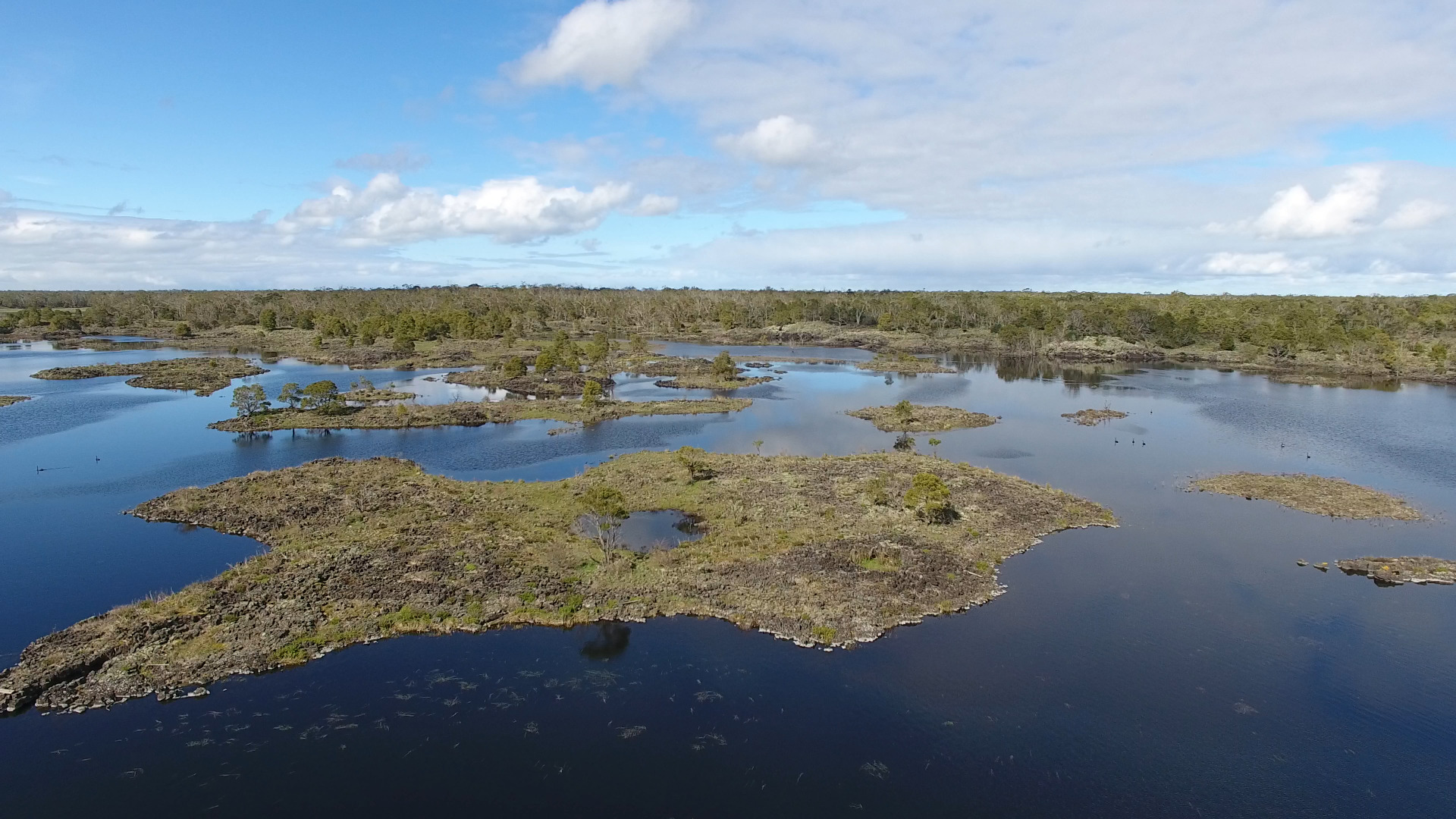
The Budj Bim Cultural Landscape, inscribed as a UNESCO World Heritage Site in 2019, offers a unique glimpse into the rich history and innovative practices of the Gunditjmara people, an Aboriginal Australian group residing in south-eastern Australia. This remarkable site encompasses three distinct components—Kurtonitj, Tyrendarra, and the Budj Bim (Lake Condah) area—which together form what is recognized as the earliest known large-scale and permanent aquaculture system in the world.
Located within the traditional Country of the Gunditjmara people, the Budj Bim Cultural Landscape is situated around the dormant volcano, Budj Bim, or Mount Eccles, in the Newer Volcanics Province of south-western Victoria. The volcanic landscape provides the foundation for the intricate network of channels, weirs, and dams engineered by the Gunditjmara over at least 6,600 years. These structures were designed to trap, store, and harvest kooyang, the short-finned eel (Anguilla australis), creating a highly productive aquaculture system that served as the economic and social backbone for Gunditjmara society.
Significantly, this system supported a semi-permanent settlement pattern, evidenced by the remains of over 150 circular stone dwellings found throughout the landscape. These findings challenge long-standing colonial assumptions that Aboriginal societies were exclusively nomadic, highlighting instead the diversity, complexity, and stability of Indigenous lifeways.
The Budj Bim Cultural Landscape is not merely a physical manifestation of human ingenuity; it is deeply rooted in the Gunditjmara creation narrative. According to their oral tradition, the Gunditjmara have inhabited this region since the dawn of time. This concept, often described as “deep time,” aligns with broader archaeological evidence indicating tens of thousands of years of Aboriginal presence in Australia. This close connection between the Gunditjmara and their land is maintained through the preservation of traditional knowledge systems passed down through generations and the continuation of cultural practices.
One of the key features of the Budj Bim Cultural Landscape is its ability to adapt to changing environmental conditions. Over thousands of years, the Gunditjmara have continually modified their aquaculture system to accommodate shifts in eel populations, water levels, and climate patterns. This dynamic relationship between the Gunditjmara and their environment underscores the resilience and adaptability of Indigenous cultures in the face of environmental challenges.
Beyond its historical significance, Budj Bim holds immense scientific value. Archaeological excavations have uncovered evidence of the Gunditjmara's sophisticated understanding of hydrology, engineering, and ecology, providing valuable insights into prehistoric societies and their interactions with their environments. Furthermore, the site serves as a testament to the potential for Indigenous knowledge systems to inform modern conservation efforts and sustainable development practices.
Today, the landscape is actively managed by the Gunditj Mirring Traditional Owners Aboriginal Corporation, who are leading efforts to restore and maintain the ancient aquaculture system, including the revival of traditional eel harvesting practices. This ongoing stewardship highlights that Budj Bim is not only an archaeological site but also a living cultural landscape.
The inscription of the Budj Bim Cultural Landscape as a UNESCO World Heritage Site marks a significant step towards acknowledging and preserving the rich heritage of the Gunditjmara people. By recognizing the importance of this site, we not only celebrate the achievements of the past but also affirm our commitment to fostering a more inclusive and culturally diverse understanding of humanity's shared history.
UNESCO Description of the World Heritage Site
The Budj Bim Cultural Landscape, located in the traditional Country of the Gunditjmara people in south-eastern Australia, consists of three serial components containing one of the world’s most extensive and oldest aquaculture systems. The Budj Bim lava flows provide the basis for the complex system of channels, weirs and dams developed by the Gunditjmara in order to trap, store and harvest kooyang (short-finned eel – Anguilla australis). The highly productive aquaculture system provided an economic and social base for Gunditjmara society for six millennia. The Budj Bim Cultural Landscape is the result of a creational process narrated by the Gunditjmara as a deep time story, referring to the idea that they have always lived there. From an archaeological perspective, deep time represents a period of at least 32,000 years. The ongoing dynamic relationship of Gunditjmara and their land is nowadays carried by knowledge systems retained through oral transmission and continuity of cultural practice.
UNESCO Justification of the World Heritage Site
Criterion (iii): The Budj Bim Cultural Landscape bears an exceptional testimony to the cultural traditions, knowledge, practices and ingenuity of the Gunditjmara. The extensive networks and antiquity of the constructed and modified aquaculture system of the Budj Bim Cultural Landscape bears testimony to the Gunditjmara as engineers and kooyang fishers. Gunditjmara knowledge and practices have endured and continue to be passed down through their Elders and are recognisable across the wetlands of the Budj Bim Cultural Landscape in the form of ancient and elaborate systems of stone-walled kooyang husbandry (or aquaculture) facilities. Gunditjmara cultural traditions, including associated storytelling, dance and basket weaving, continue to be maintained by their collective multigenerational knowledge.
Criterion (v): The continuing cultural landscape of the Budj Bim Cultural Landscape is an outstanding representative example of human interaction with the environment and testimony to the lives of the Gunditjmara. The Budj Bim Cultural Landscape was created by the Gunditjmara who purposefully harnessed the productive potential of the patchwork of wetlands on the Budj Bim lava flow. They achieved this by creating, modifying and maintaining an extensive hydrological engineering system that manipulated water flow in order to trap, store and harvest kooyang that migrate seasonally through the system. The key elements of this system are the interconnected clusters of constructed and modified water channels, weirs, dams, ponds and sinkholes in combination with the lava flow, water flow and ecology and life-cycle of kooyang. The Budj Bim Cultural Landscape exemplifies the dynamic ecological-cultural relationships evidenced in the Gunditjmara’s deliberate manipulation and management of the environment.
Encyclopedia Record: Budj Bim
Budj Bim, also known as Mount Eccles, is a dormant volcano near Macarthur in southwestern Victoria, Australia. It lies within the geologically defined area known as the Newer Volcanics Province, which is the youngest volcanic area in Australia and stretches from western Victoria to south-eastern South Australia.Additional Site Details
Area: 9,935 hectares
Number of Components: 3
(v) — Outstanding example of traditional human settlement
Coordinates: -38.0811111111 , 141.8852777778
Image
© Gunditj Mirring Traditional Owners Aboriginal Corporation. Used with permission.
