World Heritage Identification Number: 494
World Heritage since: 1990
Category: Natural Heritage
WHE Type: Protected Areas & National Parks
Transboundary Heritage: No
Endangered Heritage: No
Country: 🇲🇬 Madagascar
Continent: Africa
UNESCO World Region: Africa
Map
Andrefana Dry Forests: A Unique Ecosystem in Western Madagascar
The Andrefana Dry Forests, situated in the westernmost region of Madagascar, constitute a significant part of the UNESCO World Heritage Site known as Tsingy de Bemaraha Strict Nature Reserve. Inscribed in 1990, this site showcases a remarkable blend of geographical diversity, exceptional biodiversity, and unique evolutionary lineages that make it a must-visit destination for nature enthusiasts worldwide.
More to come…UNESCO Description of the World Heritage Site
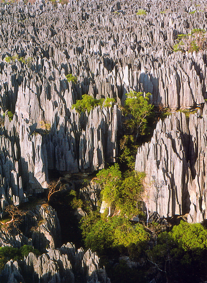
This serial property in western Madagascar comprises karstic landscapes and limestone uplands cut into impressive 'tsingy' peaks and a 'forest' of limestone needles, the spectacular canyon of the Manambolo river, rolling hills and high peaks. Undisturbed forests, lakes and mangrove swamps are the habitat for rare and endangered lemurs and birds. The component parts of the property cover almost the full range of ecological and evolutionary variation within the western forests of Madagascar, including western dry forests and southwestern spiny forest-thicket. These sites contain a spectacular array of endemic and threatened biodiversity, including baobabs, flame trees (Delonix), as well as unique evolutionary lineages such as the Mesitornithiformes, an order of birds which is 54 million years old.
UNESCO Justification of the World Heritage Site
Criterion (vii): The Tsingy de Bemaraha Strict Nature Reserve, which has since become a National Park, represents rare or highly remarkable geological phenomena of exceptional beauty. It presents impressive geological elements including karstic scenery with a highly dissected limestone massif, crossed by a deep river gorge, which is the spectacular expression of a stage of evolution of the earth in the form of a “forest of sharp stones” with high limestone pinnacles rising up to 100 metres, forming veritable cathedrals, offering a grandiose, spectacular natural landscape. Further, “the Tsingy” of the limestone plateau forms an unusual feature of outstanding beauty, unique in the world, universally recognized by the effect created by the shades of forest green on metallic reflections of the grey karst “bristles”. While not adding additional attributes, the other five component parts of this serial property contribute to the overall natural beauty of the property.
Criterion (ix): The palaeoclimatic oscillations of the last few million years have had a profound effect on the landscapes and the evolution of the fauna and flora of Madagascar. The Andrefana Dry Forests are a complex product of this process. They have retreated during dry periods; they have expanded during wet periods but with variations deeply linked to the relief with its hydrological network. The centres of endemism that are home to many endemic species and higher taxa are the “interfluves” of the great rivers that have their sources on the highest peaks of Madagascar. The centres of endemism on the western slopes were refugia that captured parts of the hydrological system, allowing animal and plant populations to survive in isolation during dry periods. The Andrefana Dry Forests are distributed over all but one of the western endemic centres. Namely from south to north in the serial property, the endemism centres of Karimbola (Tsimanampesotse National Park), Mikea (Mikea National Park), Melaky (Bemaraha National Park), Sofia (Ankarafantsika National Park), Ankarana (Ankarana Special Reserve) and Vohimarina (Analamerana Special Reserve).
Criterion (x): Madagascar’s different forest types are home to 80% of its endemic species, and the dry forests make a major contribution to this richness. The dry forests are clearly distinct from the humid forests of Madagascar with flagship groups entirely restricted to dry formations such as baobabs, most members of the family Didiereaceae, flamboyant trees, mammals, birds, reptiles, amphibians, tortoises and more than half of the scorpions. Important species also include the Perrier’s Sifaka, and the Mongoose Lemur, the Madagascar Fish Eagle and the Western Woolly Lemur. Within the orders and families endemic to Madagascar, many genera and species are found only in dry forests or thorny thickets. Even more notable are the ancient orders of fauna that are endemic to the island, such as the two endemic birds of Mikea, named after a centre of endemism and a cultural group. The presence of endemic genera, and even families of vertebrates, many of them containing species that are highly threatened, in the component parts added in 2023 is unique among dry forests of the world. The additions also include almost one thousand endemic species and sub-species of plants, 156 endemic reptiles, 57 endemic mammals and 34 endemic amphibians.
Encyclopedia Record: Tsingy de Bemaraha Strict Nature Reserve
Tsingy de Bemaraha Strict Nature Reserve is a nature reserve located near the western coast of Madagascar in Melaky Region. The area was listed as a UNESCO World Heritage Site in 1990 due to the unique geography, preserved mangrove forests, and wild bird and lemur populations.Additional Site Details
Area: 734,298 hectares
Number of Components: 6
(ix) — Outstanding example representing ecological and biological processes
(x) — Contains most important habitats for biodiversity
Coordinates: -18.6615777778 , 44.7673861111
IUCN World Heritage Outlook
The 2025 Conservation Outlook on Andrefana Dry Forests reports the following assessment:
Source: International Union for Conservation of Nature (IUCN) · View assessment
Image
© My father (who approves of its use), CC BY-SA 3.0 Resized from original. (This derivative is under the same CC BY-SA license.)
