World Heritage Identification Number: 1257
World Heritage since: 2007
Category: Natural Heritage
WHE Type: Natural Landscapes & Geographic Features
Transboundary Heritage: No
Endangered Heritage: No
Country: 🇲🇬 Madagascar
Continent: Africa
UNESCO World Region: Africa
Map
The Rainforests of the Atsinanana: A Unique Biodiversity Haven in Eastern Madagascar
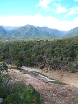
The Rainforests of the Atsinanana, inscribed as a UNESCO World Heritage Site in 2007, represent a significant portion of the eastern part of Madagascar. This designation encompasses 13 distinct areas within six national parks, each playing a crucial role in preserving the island's unique biodiversity.
These rainforests are a testament to Madagascar's long geological and evolutionary isolation. The island separated from the African continent about 160-165 million years ago and the Indian subcontinent approximately 88-90 million years ago, leading to the development of an extraordinary range of flora and fauna found nowhere else on Earth. The site is recognized for its importance in ongoing ecological and evolutionary processes, as well as for its exceptional biodiversity and the numerous threatened species it harbors.
The Rainforests of the Atsinanana are of outstanding importance for the study of ongoing ecological and evolutionary processes. Isolated for millions of years, Madagascar’s eastern rainforests function as a living laboratory of evolution, where species diversification continues to occur in response to highly varied microclimates and habitats. This makes the site globally significant for understanding how life evolves in long-isolated tropical ecosystems.
Rather than forming a single continuous forest, the rainforests consist of a series of fragmented protected areas distributed along Madagascar’s eastern escarpment. This fragmented structure reflects both natural variation in topography and the long history of human land use in the region. Despite their separation, these forest blocks collectively preserve key ecological processes and serve as critical refuges for Madagascar’s remaining rainforest species.
The site includes six national parks: Marojejy National Park, Masoala National Park, Zahamena National Park, Ranomafana National Park, Andringitra National Park, and Andohahela National Park.
Marojejy National Park is known for its steep rainforest-covered mountains and exceptional levels of endemism. Among its most notable species is the silky sifaka (Propithecus candidus), one of the world’s rarest primates. Masoala National Park, another key component of the site, supports an exceptionally rich array of wildlife, including the red ruffed lemur (Varecia rubra) and other highly threatened endemic species.
Zahamena National Park, Ranomafana National Park, Andringitra National Park, and Andohahela National Park each contribute distinct ecological characteristics to the Rainforests of the Atsinanana. Zahamena National Park is notable for its dense lowland rainforest and rich biodiversity, including the fossa (Cryptoprocta ferox), Madagascar’s largest native predator.
Ranomafana National Park is renowned for its hot springs and diverse lemur populations, including several species discovered relatively recently. Andringitra National Park is characterized by its dramatic granite massifs, high-altitude ecosystems, and montane grasslands, while Andohahela National Park is especially important for containing a sharp ecological transition between humid rainforest and dry spiny forest.
The forests support exceptional plant diversity, with Madagascar as a whole hosting roughly 11,000–13,000 plant species—the vast majority of which are endemic. A large proportion of this botanical diversity is represented within the eastern rainforest ecosystems. The combination of steep altitudinal gradients, high rainfall, and varied microhabitats has produced a wide range of plant communities, from lowland rainforest to montane forest ecosystems. This botanical diversity plays a fundamental role in maintaining the ecological stability and resilience of the region’s rainforest systems.
However, the forests face significant threats, including deforestation, habitat fragmentation, mining, and climate change. In 2025, the Rainforests of the Atsinanana were removed from the List of World Heritage in Danger following improvements in conservation measures and a significant reduction in some of the threats that had led to their 2010 listing. Despite this milestone, conservation efforts involving local communities, government authorities, and international organizations remain critical to combatting long-term threats such as illegal logging and slash-and-burn agriculture (tavy).
Altogether, the Rainforests of the Atsinanana stand as one of the world’s most important centers of biodiversity and endemism. As a UNESCO World Heritage Site recognized for its natural values, these forests are protected for their ecological and evolutionary significance. By supporting conservation efforts and promoting sustainable tourism, we can help ensure the long-term survival of this unique and irreplaceable treasure.
UNESCO Description of the World Heritage Site
The Rainforests of the Atsinanana comprise six national parks distributed along the eastern part of the island. These relict forests are critically important for maintaining ongoing ecological processes necessary for the survival of Madagascar’s unique biodiversity, which reflects the island’s geological history. Having completed its separation from all other land masses more than 60 million years ago, Madagascar’s plant and animal life evolved in isolation. The rainforests are inscribed for their importance to both ecological and biological processes as well as their biodiversity and the threatened species they support. Many species are rare and threatened especially primates and lemurs.
UNESCO Justification of the World Heritage Site
Criterion (ix): The Rainforests of the Atsinanana are relict forests, largely associated with steeper terrain along the eastern escarpment and mountains of Madagascar. The protected areas included in this serial property have become critically important for maintaining ongoing ecological processes necessary for the survival of Madagascar's unique biodiversity. This biodiversity reflects Madagascar's geological history and geographic placement. It is the world's fourth largest island and has been separated from all other land masses for at least 60-80 million years and thus most of its plant and animal life has evolved in isolation. These forests have also offered important refuge for species during past periods of climate change and will be essential for the adaptation and survival of species in the light of future climate change.
Criterion (x): The level of endemism within the property is approximately 80 to 90 percent for all groups, and endemic families and genera are common. Madagascar is among the top countries known for their megadiversity and features an extraordinarily high number (circa 12,000) of endemic plant species. The property is also globally significant for fauna, especially primates, with all five families of Malagasy primates, all endemic lemur families, seven endemic genera of Rodentia, six endemic genera of Carnivora, as well as several species of Chiroptera represented. Of the 123 species of non-flying mammals in Madagascar (72 of which are on the IUCN Red List of Threatened Species), 78 occur within the property. The critical importance of the property is underlined by the fact that deforestation has left eastern Madagascar with only 8.5 percent of its original forests and the property protects key areas of this remaining habitat.
Encyclopedia Record: Rainforests of the Atsinanana
The Rainforests of the Atsinanana is a World Heritage Site that was inscribed in 2007 and consists of 13 specific areas in six national parks in the eastern part of Madagascar:Marojejy National Park Masoala National Park Zahamena National Park Ranomafana National Park Andringitra National Park Andohahela National ParkAdditional Site Details
Area: 479,660.7 hectares
Number of Components: 13
(x) — Contains most important habitats for biodiversity
Coordinates: -14.4597222222 , 49.7025
IUCN World Heritage Outlook
The 2025 Conservation Outlook on Rainforests of the Atsinanana reports the following assessment:
Source: International Union for Conservation of Nature (IUCN) · View assessment
Image
© No machine-readable author provided. Masindrano~commonswiki assumed (based on copyright claims)., CC BY-SA 3.0 Resized from original. (This derivative is under the same CC BY-SA license.)
