World Heritage Identification Number: 668
World Heritage since: 1992
Category: Cultural Heritage
WHE Type: Buildings & Architectural Ensembles
Transboundary Heritage: No
Endangered Heritage: No
Country: 🇰🇭 Cambodia
Continent: Asia
UNESCO World Region: Asia and the Pacific
Map
Angkor: A Glimpse into the Ancient Khmer Empire
The ancient city of Angkor, officially known as Yasodharapura, serves as a testament to the grandeur and cultural prowess of the Khmer Empire, which thrived in Southeast Asia between the 9th and 15th centuries. This sprawling archaeological site, spanning over 400 square kilometers, including forested areas, is inscribed as a UNESCO World Heritage Site and stands as one of the most significant historical landmarks in the region.
Located in present-day Cambodia, Angkor boasts the impressive Temple of Angkor Wat, a monumental structure that exemplifies the architectural brilliance of the Khmer civilization. Constructed during the reign of King Suryavarman II in the early 12th century, Angkor Wat is dedicated to the Hindu deity Vishnu and is adorned with intricate carvings depicting scenes from Hindu mythology. The temple complex, with its five towers symbolizing the five peaks of Mount Meru, is a marvel of symmetry and engineering, showcasing the advanced skills of the Khmer builders.
Another notable attraction within the Angkor Archaeological Park is the Bayon Temple, situated within the walls of Angkor Thom, the last and most enduring capital city of the Khmer Empire. The Bayon Temple, built during the reign of King Jayavarman VII, is renowned for its extensive sculptural decorations often interpreted as representing the enigmatic faces of Avalokiteshvara, the Buddhist deity of compassion, though some scholars also suggest they could represent Jayavarman VII himself. The temple complex, with its central tower rising above the surrounding structures, offers a unique insight into the religious syncretism that characterized the Khmer Empire, blending elements of Hinduism and Buddhism.
The Angkor Archaeological Park is not limited to these two iconic temples; it encompasses numerous other sites, each offering a glimpse into the rich history and culture of the Khmer Empire. These include Baphuon, Ta Prohm, Preah Khan, and Srah Srang, among others. Each site tells a story of the Khmer civilization, revealing their artistic, architectural, and religious achievements.
The preservation and protection of Angkor have been a priority for UNESCO since its inscription as a World Heritage Site in 1992. The organization has implemented various conservation measures aimed at safeguarding this symbolic site and its surroundings. These efforts include the restoration of damaged structures, the implementation of sustainable tourism practices, and the establishment of educational programs to promote awareness and understanding of the site's significance.
In summary, Angkor stands as a remarkable reminder of the once powerful Khmer Empire. Its intricate temples, carved with stories of gods and kings, serve as a window into the past, offering insights into the beliefs, values, and artistic abilities of the Khmer people. As a UNESCO World Heritage Site, Angkor continues to captivate visitors from around the world, inviting them to explore the mysteries of this ancient civilization and appreciate the enduring legacy it has left behind.
UNESCO Description of the World Heritage Site
Angkor is one of the most important archaeological sites in South-East Asia. Stretching over some 400 km2, including forested area, Angkor Archaeological Park contains the magnificent remains of the different capitals of the Khmer Empire, from the 9th to the 15th century. They include the famous Temple of Angkor Wat and, at Angkor Thom, the Bayon Temple with its countless sculptural decorations. UNESCO has set up a wide-ranging programme to safeguard this symbolic site and its surroundings.
UNESCO Justification of the World Heritage Site
Criterion (i): The Angkor complex represents the entire range of Khmer art from the 9th to the 14th centuries, and includes a number of indisputable artistic masterpieces (e.g. Angkor Wat, the Bayon, Banteay Srei).
Criterion (ii): The influence of Khmer art as developed at Angkor was a profound one over much of South-east Asia and played a fundamental role in its distinctive evolution.
Criterion (iii): The Khmer Empire of the 9th-14th centuries encompassed much of South-east Asia and played a formative role in the political and cultural development of the region. All that remains of that civilization is its rich heritage of cult structures in brick and stone.
Criterion (iv): Khmer architecture evolved largely from that of the Indian sub-continent, from which it soon became clearly distinct as it developed its own special characteristics, some independently evolved and others acquired from neighboring cultural traditions. The result was a new artistic horizon in oriental art and architecture.
Encyclopedia Record: Angkor
Angkor, also known as Yasodharapura, was the capital city of the Khmer Empire, located in present-day Cambodia. The empire flourished from approximately the 9th to the 15th centuries. The site of Angkor has a variety of religious temples, libraries, moats, and other buildings. These other buildings could have been used by officials to the grand palace housing the Khmer king. Those constructed outside the main complex were not made of stone. One of the more visited places in Angkor is Angkor Wat, a temple complex that is one of Cambodia's tourist attractions.Additional Site Details
Area: 40,100 hectares
Number of Components: 3
(ii) — Significant interchange of human values
(iii) — Unique or exceptional testimony to a cultural tradition
(iv) — Outstanding example of a type of building or landscape
Coordinates: 13.43333333 , 103.8333333
Image
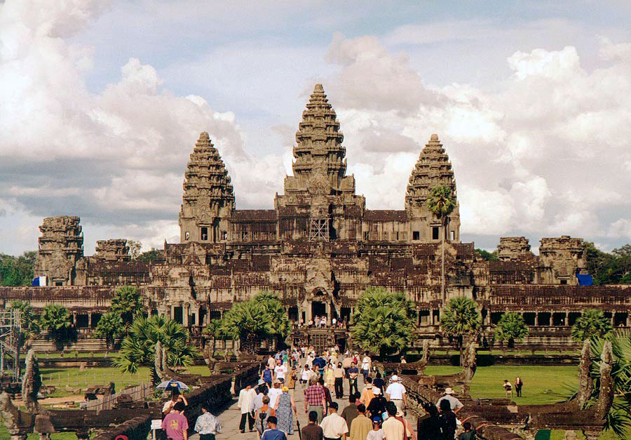
© Manfred Werner (talk · contribs), CC BY-SA 3.0 Resized from original. (This derivative is under the same CC BY-SA license.)
World Heritage Research
Discover scientific research and academic studies that deepen our understanding of Angkor from its history and significance to its conservation, management, and contemporary challenges.
-
Angkor
Severe climate change in the fourteenth century led to catastrophic flooding and drought at Angkor, disrupting its water management system and contributing to the site's decline. This study reveals that mega-monsoons eroded central canals and deposited sand, reducing Greater Angkor's resilience to subsequent droughts—a critical factor in its transformation from a thriving urban complex to an early modern settlement form by the sixteenth century. The research traces Angkor's evolution from two low-density towns (Bhavapura and Hariharalaya) into a multicentric city, with development expanding westward, southward, and northward before stabilizing in the thirteenth century.
Fletcher, R., & Pottier, C. (2022). Angkor. The Oxford Handbook of Early Southeast Asia, 703–731. https://doi.org/10.1093/oxfordhb/9780199355358.013.33
View Publication Record | Read Publication -
Angkor Heritage Tourism and Tourist Perceptions
Tourist perceptions of Angkor are overwhelmingly positive, with visitors reporting experiences that exceed expectations due to cultural enrichment and the friendliness of local people. The study categorizes tourists primarily as cultural visitors, whose motives and experiences are deeply intertwined. While overall satisfaction is high, concerns about environmental pollution, sanitation, local poverty, and language barriers were identified, highlighting gaps in communication and infrastructure. This research, based on a survey using standard questionnaires, provides valuable insights into the factors influencing tourist satisfaction at Angkor, underscoring both its appeal as a cultural destination and the challenges that need addressing to enhance visitor experiences.
Chheang, V. (2011). ANGKOR HERITAGE TOURISM AND TOURIST PERCEPTIONS. Tourismos, Vol. 6 No. 2 (2011). https://doi.org/10.26215/TOURISMOS.V6I2.228
View Publication Record | Read Publication -
Three-dimensional deformation monitoring and simulations for the preventive conservation of architectural heritage: a case study of the Angkor Wat Temple, Cambodia
Researchers detected subtle structural instabilities at Angkor Wat, with deformation rates up to 3 mm/year, despite the temple's overall stability. These findings highlight the vulnerability of architectural heritage to thermal-induced bending and potential defects from solar radiation. The study introduced an innovative methodology combining differential SAR tomography (D-TomoSAR) and finite element method (FEM) simulations, addressing limitations in traditional geodetic approaches like GNSS and InSAR. By analyzing 46 TerraSAR-X images from 2011–2013, the team demonstrated how integrating InSAR measurements improved deformation simulation accuracy, providing a robust framework for preventive conservation of global heritage sites.
Chen, F., Xu, H., Zhou, W., Zheng, W., Deng, Y., & Parcharidis, I. (2021). Three-dimensional deformation monitoring and simulations for the preventive conservation of architectural heritage: a case study of the Angkor Wat Temple, Cambodia. GIScience & Remote Sensing, 58(2), 217–234. https://doi.org/10.1080/15481603.2020.1871188
View Publication Record | Read Publication -
Diachronic modeling of the population within the medieval Greater Angkor Region settlement complex
A groundbreaking study estimates that the medieval Greater Angkor Region, one of the world's largest premodern settlement complexes (9th to 15th centuries CE), housed approximately 700,000 to 900,000 inhabitants at its peak in the 13th century. This finding, derived from a novel integration of lidar data, archaeological excavations, radiocarbon dating, and machine learning algorithms, provides the first comprehensive demographic model for Angkor. The research offers a granular, diachronic perspective on population growth within this ancient civilization, with potential applications for studying other historical urban centers.
Klassen, S., Carter, A. K., Evans, D. H., Ortman, S., Stark, M. T., Loyless, A. A., Polkinghorne, M., Heng, P., Hill, M., Wijker, P., Niles-Weed, J., Marriner, G. P., Pottier, C., & Fletcher, R. J. (2021). Diachronic modeling of the population within the medieval Greater Angkor Region settlement complex. Science Advances, 7(19). https://doi.org/10.1126/sciadv.abf8441
View Publication Record | Read Publication -
The evolution of agro-urbanism: A case study from Angkor, Cambodia
Angkor, Cambodia, stands as the world's most extensive pre-industrial settlement complex, with its low-density metropolitan area and higher-density civic-ceremonial center growing independently at different rates. This study reveals that both state-level policies and infrastructure, alongside bottom-up local organization, drove Angkor's expansion. By employing a unique fine-grained diachronic analysis of the landscape, researchers identified how these factors contributed to the site's evolution over time. The findings suggest that similar patterns may emerge in comparative studies of other agro-urban settlements in Mesoamerica and Asia.
Carter, A. K., Klassen, S., Stark, M. T., Polkinghorne, M., Heng, P., Evans, D., & Chhay, R. (2021). The evolution of agro-urbanism: A case study from Angkor, Cambodia. Journal of Anthropological Archaeology, 63, 101323. https://doi.org/10.1016/j.jaa.2021.101323
View Publication Record | Read Publication -
Provisioning an Early City: Spatial Equilibrium in the Agricultural Economy at Angkor, Cambodia
Agricultural production at Angkor, one of the most extensive preindustrial cities, was organized to support urban growth efficiently. The study reveals that farming labor generated increasing returns through supra-household-level organization, challenging traditional economic anthropology views on decreasing marginal returns. Spatial patterns indicate land-use choices considered transportation costs to the urban core, suggesting a system more akin to modern urban production than smallholder farming. The research leverages extensive documentation of the Greater Angkor Region to analyze these spatial and social dynamics.
Klassen, S., Ortman, S. G., Lobo, J., & Evans, D. (2021). Provisioning an Early City: Spatial Equilibrium in the Agricultural Economy at Angkor, Cambodia. Journal of Archaeological Method and Theory, 29(3), 763–794. https://doi.org/10.1007/s10816-021-09535-5
View Publication Record | Read Publication -
Top-down and bottom-up water management: A diachronic model of changing water management strategies at Angkor, Cambodia
Research at Angkor, Cambodia, reveals that the Khmer Empire's water management strategies evolved from decentralized community-led efforts to centralized state-controlled systems. By integrating diverse archaeological datasets and creating diachronic models, scientists traced the emergence of temple communities alongside large-scale hydraulic infrastructure over 1000 km². The findings indicate a shift in power dynamics, with autonomous temple communities being gradually replaced by state-sponsored agricultural units, reflecting the empire's attempt to centralize production during its peak (9th to 15th centuries CE). This transformation underscores the complex interplay between top-down and bottom-up water management in shaping one of history's most sophisticated engineered landscapes.
Klassen, S., & Evans, D. (2020). Top-down and bottom-up water management: A diachronic model of changing water management strategies at Angkor, Cambodia. Journal of Anthropological Archaeology, 58, 101166. https://doi.org/10.1016/j.jaa.2020.101166
View Publication Record | Read Publication