World Heritage Identification Number: 1667
World Heritage since: 2023
Category: Cultural Heritage
WHE Type: Archaeological Sites
Transboundary Heritage: No
Endangered Heritage: No
Country: 🇰🇭 Cambodia
Continent: Asia
UNESCO World Region: Asia and the Pacific
Map
Koh Ker: A Forgotten Capital of the Khmer Empire
The archaeological site of Koh Ker, also known as Ancient Lingapura or Chok Gargyar, is a captivating testament to the rich history and cultural prowess of the Khmer Empire. Inscribed as a UNESCO World Heritage Site in 2023, this remote location in northern Cambodia offers a unique glimpse into the architectural, artistic, and religious practices of a civilization that thrived more than a millennium ago.
Established as the capital by King Jayavarman IV between 928 and 944 CE, Koh Ker served as the seat of power when the capital was temporarily moved from the famous Angkor region. The city's unusual layout and innovative design elements set it apart from its contemporaries, demonstrating the kingdom's unconventional approach to city planning, artistic expression, and construction technology.
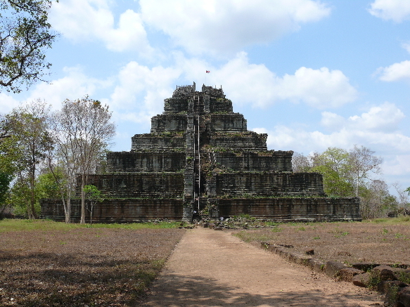
One of the most striking features of Koh Ker is its extensive use of large monolithic stone blocks. This technique, which required significant engineering expertise, can be seen throughout the site, particularly in the construction of temples and sanctuaries. Among these structures, Prasat Thom, a seven-tiered pyramid temple dedicated to Shiva, stands as the tallest monument at Koh Ker, reaching a height of approximately 36 meters (118 feet).
The sacred urban ensemble of Koh Ker encompasses more than 180 sanctuaries within a protected area of 81 square kilometers (31 square miles). However, due to its remote location and the presence of unexploded ordnance, only around two dozen monuments are accessible to tourists. These include Prasat Bak, Prasat Kraom, and Prasat Damrei (the Elephant Temple), each showcasing intricate carvings and inscriptions that offer insights into the religious beliefs and the distinct style of sculpture.
A defining aspect of the site’s heritage is the "Koh Ker Style," which marked a radical departure from earlier Khmer art. Unlike the static, serene figures of the Angkorian period, Koh Ker’s sculptures are characterized by their immense scale and dynamic movement.
Artisans during the reign of Jayavarman IV began depicting deities in action—such as the famous wrestling monkeys or dancing Shivas—capturing a sense of vitality and drama previously unseen. These masterpieces, often carved from single blocks of sandstone, are considered some of the finest examples of Southeast Asian art.
The city plan of Koh Ker was believed to be based on ancient Indian religious concepts of the universe. This cosmological influence can be observed in the arrangement of temples, roads, and barays (reservoirs), creating a harmonious balance that reflects the divine order of the universe.
Despite its historical significance, Koh Ker remains relatively unknown and tranquil compared to its more popular counterpart, Angkor. Its remote location and dense jungle environment have contributed to its preservation but also pose challenges for archaeologists and visitors alike. As efforts continue to clear the landmines and restore the site, Koh Ker promises to reveal even more of its secrets, offering a fascinating glimpse into the lost city of the Khmer Empire.
Altogether, Koh Ker stands as a vital key to unlocking the complex history and cultural achievements of the Khmer Empire. Its daring architecture, visionary city planning, and remarkable artistic heritage make it a jewel among UNESCO World Heritage Sites. Exploring and preserving this forgotten capital offers a rare window into the lives, beliefs, and creativity of its people, deepening our appreciation for the enduring richness of human history.
UNESCO Description of the World Heritage Site
The archaeological site of Koh Ker is a sacred urban ensemble of numerous temples and sanctuaries including sculptures, inscriptions, wall paintings, and archaeological remains. Constructed over a twenty-three-year period, it was one of two rival Khmer Empire capitals – the other being Angkor – and was the sole capital from 928 to 944 CE. Established by King Jayavarman IV, his sacred city was believed to be laid out on the basis of ancient Indian religious concepts of the universe. The new city demonstrated unconventional city planning, artistic expression and construction technology, especially the use of very large monolithic stone blocks.UNESCO Justification of the World Heritage Site
Criterion (ii): The archaeological site of Koh Ker exhibits in an exceptional way the interchange of human values that resulted in the Koh Ker Style, a sculptural expression featuring bold, expressive imagery and a dynamic sense of movement that resulted from the fusion of Indian religious and artistic symbolism with local design concepts and artistic craftsmanship. The Koh Ker Style, though formed within a short period of twenty-three years in the 10th century, had an enduring influence on the artistic expression of the subsequent period of the Khmer Empire and other Southeast Asian countries.
Criterion (iv): The archaeological site of Koh Ker is a prototype of a new urban landscape featured by grand-scale buildings, thanks to the use of colossal monolithic stone blocks for construction and sculptures. It had inaugurated a centuries-long phase of stone temple construction across the Khmer Empire and became a source of inspiration for the great monuments of Angkor and Southeast Asia in later centuries.
Encyclopedia Record: Koh Ker
Koh Ker is a remote archaeological site in northern Cambodia about 120 kilometres (75 mi) away from Siem Reap and the ancient site of Angkor. It is a jungle filled region that is sparsely populated. More than 180 sanctuaries were found in a protected area of 81 square kilometres (31 sq mi). Only about two dozen monuments can be visited by tourists because most of the sanctuaries are hidden in the forest and the whole area is not fully demined.Additional Site Details
Area: 1,187.61 hectares
Number of Components: 1
(iv) — Outstanding example of a type of building or landscape
Coordinates: 13.7830555556 , 104.5372222222
World Heritage Research
Discover scientific research and academic studies that deepen our understanding of Koh Ker: Archaeological Site of Ancient Lingapura or Chok Gargyar from its history and significance to its conservation, management, and contemporary challenges.
-
Using ground penetrating radar to understand the failure of the Koh Ker Reservoir, Northern Cambodia.
A flawed design in the Koh Ker Reservoir's spillway, revealed through ground penetrating radar and topographic mapping, likely contributed to its failure during the first rainy season after construction. This inadequacy exacerbated water flow issues, potentially accelerating the collapse of the reservoir's dike and thereby shortening Koh Ker's tenure as a political center of the Khmer Empire. The study employed advanced geophysical techniques to reconstruct the buried laterite pavement, providing new insights into ancient hydraulic engineering failures.
Moffat, I., klassen, s., Attorre, T., Evans, D., Lustig, T., & Kong, L. (2021). Using ground penetrating radar to understand the failure of the Koh Ker Reservoir, Northern Cambodia. https://doi.org/10.31219/osf.io/6xcvu
View Publication Record | Read Publication -
Using ground penetrating radar to understand the failure of the Koh Ker Reservoir, Northern Cambodia
New evidence from ground penetrating radar and excavation reveals that the Koh Ker Reservoir, built during the Angkorian period in Cambodia, suffered from a critical design flaw. The spillway's laterite pavement was even less effective at managing water flow than previously estimated, likely contributing to the reservoir's dike failure during its first rainy season after construction. This structural failure may have played a pivotal role in Koh Ker's brief tenure as the political center of the Khmer Empire, highlighting the vulnerability of ancient hydraulic engineering to environmental stresses.
Moffat, I., Klassen, S., Attorre, T., Evans, D., Lustig, T., & Kong, L. (2019). Using ground penetrating radar to understand the failure of the Koh Ker Reservoir, Northern Cambodia. Geoarchaeology, 35(1), 63–71. Portico. https://doi.org/10.1002/gea.21757
View Publication Record | Read Publication -
Re-evaluating the occupation history of Koh Ker, Cambodia, during the Angkor period: A palaeo-ecological approach
Palaeoecological and geoarchaeological evidence reveals that Koh Ker, Cambodia, remained occupied by its domestic population for several centuries after the royal court relocated to Angkor in the 10th century. This challenges the long-held assumption that the city's abandonment by the elite marked the end of its occupation. The study employed multi-proxy environmental reconstructions—including sediment analysis and plant remains—to trace human activity and land use patterns, demonstrating their persistence well beyond the documented political shifts. These findings underscore the value of integrating palaeoecological data to refine our understanding of Khmer urban dynamics during the Angkor period.
Hall, T., Penny, D., & Hamilton, R. (2018). Re-evaluating the occupation history of Koh Ker, Cambodia, during the Angkor period: A palaeo-ecological approach. Plos One, 13(10), e0203962. https://doi.org/10.1371/journal.pone.0203962
View Publication Record | Read Publication -
Új irányok a khmer településtörténeti hálózatok kutatásában (Koh Ker, Kambodzsa)
New LIDAR surveys of Koh Ker, Cambodia, reveal the site as a complex network of habitation, significantly altering our understanding of its settlement history. Previous research focused on isolated temples and visible structures, but these findings highlight the importance of exploring communication channels like streets and hydraulic systems, as well as surrounding settlements and industries. This approach provides critical insights into human environmental intervention and the development of Koh Ker, a former royal center, offering a more comprehensive framework for interpreting its past occupation.
Belényesy, K. (2018). Új irányok a khmer településtörténeti hálózatok kutatásában (Koh Ker, Kambodzsa). Távol-Keleti Tanulmányok, 9(2017/1). https://doi.org/10.38144/tkt.2017.1.8
View Publication Record | Read Publication -
The Ancient Khmer's Dimensional Planning at the Prasat Pram in Koh Ker
A new analysis of the Prasat Pram temple at Koh Ker, Cambodia, reveals that its architectural planning follows a consistent dimensional system also used across other temples in the site. This study confirms a previously proposed construction measure and provides insights into the scale and layout features unique to Khmer temples in Koh Ker. By focusing on this small but representative structure, researchers have uncovered patterns that likely apply to the broader archaeological landscape of the ancient city.
MIZOGUCHI, A., NAKAGAWA, T., SATO, K., & SHIMODA, I. (2010). THE ANCIENT KHMER’S DIMENSIONAL PLANNING AT THE PRASAT PRAM IN KOH KER. Journal of Architecture and Planning (Transactions of AIJ), 75(651), 1273–1278. https://doi.org/10.3130/aija.75.1273
View Publication Record | Read Publication -
The Ancient Khmer's Dimensional Planning at the Prasat Thom in Koh Ker
Research at the Prasat Thom temple in Koh Ker reveals intricate dimensional planning and expansion phases of the ancient Khmer structure. The study deciphers the original plan and subsequent modifications, excluding the pyramid-temple (Prang), by analyzing measured dimensions and comparing them with previous findings from Prasat Pram. This approach allows for the reconstruction of the temple's evolution, highlighting its complex design and multiple expansion stages. The findings contribute to understanding the sophisticated architectural strategies employed by ancient Khmer civilizations.
MIZOGUCHI, A., NAKAGAWA, T., SATO, K., & SHIMODA, I. (2010). THE ANCIENT KHMER’S DIMENSIONAL PLANNING AT THE PRASAT THOM IN KOH KER. Journal of Architecture and Planning (Transactions of AIJ), 75(653), 1751–1759. https://doi.org/10.3130/aija.75.1751
View Publication Record | Read Publication -
The Archaeological Landscape of Koh Ker, Northwest Cambodia
Recent archaeological research at Koh Ker, Cambodia, has uncovered a sophisticated hydraulic engineering system dating back to the 10th century, drawing parallels with the more extensive network at Angkor. Aerial and ground-based surveys revealed evidence of intensive agriculture during the Angkorian period, challenged previous interpretations of 'roadways' and 'city enclosures,' and identified domestic habitation and stone-working sites. The study also found indications of continuous occupation from early historic to post-Angkorian periods, along with signs of a collapsed water management system and significant environmental changes affecting river flows. This research sheds new light on the complexity and resilience of Koh Ker's archaeological landscape.
Evans, D. (2010). The Archaeological Landscape of Koh Ker, Northwest Cambodia. Bulletin de l’Ecole Française d’Extrême-Orient, 97(1), 91–150. https://doi.org/10.3406/befeo.2010.6130
View Publication Record | Read Publication