World Heritage Identification Number: 1475
World Heritage since: 2016
Category: Mixed Cultural Heritage and Natural Heritage
WHE Type: Natural Landscapes & Geographic Features
Transboundary Heritage: No
Endangered Heritage: No
Country: 🇹🇩 Chad
Continent: Africa
UNESCO World Region: Africa
Map
The Ennedi Massif: A Unique Blend of Nature and Culture in Northeastern Chad
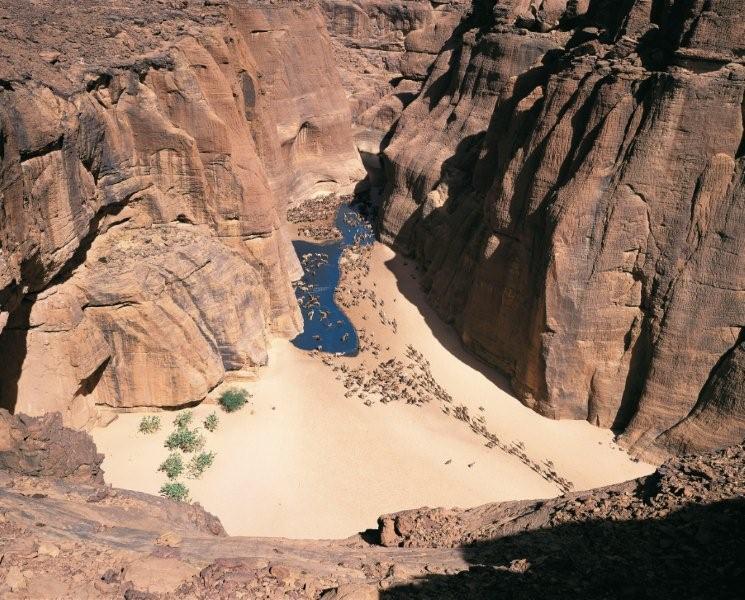
The Ennedi Massif, a natural and cultural landscape, is a remarkable geological formation situated in the northeastern regions of Chad. This vast sandstone plateau, a testament to the power of wind and water erosion, offers an extraordinary landscape characterized by deep canyons, towering cliffs, natural arches, and distinctive pitons.
More to come…UNESCO Description of the World Heritage Site
In the northeast of the country, the sandstone Ennedi Massif has been sculpted over time by water and wind erosion into a plateau featuring canyons and valleys that present a spectacular landscape marked by cliffs, natural arches and pitons. In the largest canyons, the permanent presence of water plays an essential role in the Massif’s ecosystem, sustaining flora and fauna as well as human life. Thousands of images have been painted and carved into the rock surface of caves, canyons and shelters, presenting one of the largest ensembles of rock art in the Sahara.
Encyclopedia Record: Ennedi Plateau
The Ennedi Plateau is located in the northeast of Chad, in the regions of Ennedi-Ouest and Ennedi-Est. It is considered a part of the group of mountains known as the Ennedi Massif found in Chad, which is one of the nine countries that make up the Sahelian belt that spans the Atlantic Ocean to Sudan. The Ennedi is a sandstone bulwark in the middle of the Sahara, which was formed by erosion from wind and temperature. Many people occupied this area, such as hunters-gatherers and pastoralists. The Ennedi area is also known for its large collection of rock art depicting mainly cattle, as these animals had the greatest financial, environmental, and cultural impact. This art dates back nearly 7,000 years ago. Today, two semi-nomadic groups, mainly Muslim, live in the Ennedi during the rainy months and pass through the area during the dry season. They rely on their herds of camels, donkeys, sheep, and goats to survive.Additional Site Details
Area: 2,441,200 hectares
Number of Components: 1
(vii) — Contains superlative natural phenomena or beauty
(ix) — Outstanding example representing ecological and biological processes
Coordinates: 17.0416666667 , 21.8627777778
IUCN World Heritage Outlook
The 2025 Conservation Outlook on Ennedi Massif: Natural and Cultural Landscape reports the following assessment:
Source: International Union for Conservation of Nature (IUCN) · View assessment
Image
© Desertman, CC BY-SA 3.0 Resized from original. (This derivative is under the same CC BY-SA license.)
