World Heritage Identification Number: 189
World Heritage since: 1982
Category: Cultural Heritage
WHE Type: Historic Cities & Urban Areas
Transboundary Heritage: No
Endangered Heritage: No
Country: 🇧🇷 Brazil
Continent: Americas
UNESCO World Region: Latin America and the Caribbean
Map
The Historic Centre of the Town of Olinda: A Colonial Gem in Brazil
The Historic Centre of the Town of Olinda, located in the state of Pernambuco, Brazil, stands as a testament to the rich cultural heritage of the country. Established in the 16th century by the Portuguese, this charming town boasts a history deeply intertwined with the sugar-cane industry.
More to come…UNESCO Description of the World Heritage Site
Founded in the 16th century by the Portuguese, the town’s history is linked to the sugar-cane industry. Rebuilt after being looted by the Dutch, its basic urban fabric dates from the 18th century. The harmonious balance between the buildings, gardens, 20 Baroque churches, convents and numerous small passos (chapels) all contribute to Olinda’s particular charm.
UNESCO Justification of the World Heritage Site
Criterion (ii): The historic centre of Olinda contains a number of buildings that are outstanding from the point of view of both their architecture and decoration, including the Catedral Alto da Sé, the church of Nossa Senhora da Graça and examples of civil architecture ranging from the 17th to 19th centuries. The lush vegetation of the roadsides, gardens, hedgerows and convent precincts all form a landscape in which the salient feature is the town nestling in a mass of greenery, bathed in tropical light, with the sandy shore and ocean below.
Criterion (iv): From the last years of the 16th century onward, Olinda served as one of the most important centres of the sugarcane industry, which for almost two centuries was the mainstay of the Brazilian economy, and became the symbol of sugar and of the wealth it procured. The exceptional ensemble of landscape, urbanism and architecture in Olinda’s historic centre is an eloquent reflection of the prosperity nourished by the sugar economy.
Encyclopedia Record: Olinda
Olinda is a historic city in Pernambuco, Brazil, in the Northeast Region. It is located on the country's northeastern Atlantic Ocean coast, in the Metropolitan Region of Recife, the state capital. It has a population of 349,976 people, covers 41.681 square kilometres (16.093 mi2), and has a population density of 9,437 inhabitants per square kilometre (24,440/sq mi). It is noted as one of the best-preserved colonial cities in Brazil and has been inhabited since 1535.Additional Site Details
Area: 190.9 hectares
Number of Components: 1
(iv) — Outstanding example of a type of building or landscape
Coordinates: -8.013333333 , -34.845
Image
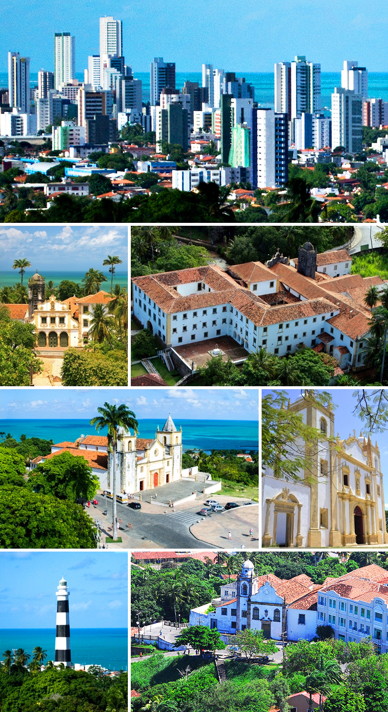
© Allice Hunter, CC BY-SA 4.0 Resized from original. (This derivative is under the same CC BY-SA license.)
World Heritage Research
Discover scientific research and academic studies that deepen our understanding of Historic Centre of the Town of Olinda from its history and significance to its conservation, management, and contemporary challenges.
-
Mobilidade da população de origem europeia na América Portuguesa no século XVII: povoamento, negócios e conflitos armados
Portuguese mobility in 17th-century America was driven by strategic movements for land acquisition, trade, and conflict, with key hubs like Salvador da Bahia, Olinda, Recife, and Belém serving as both arrival points and launchpads for inland expansion. Using inquisitorial trials, the study reveals how the sugar industry, religion, and armed conflicts shaped population displacement between captaincies, illustrating the complex interplay of economic and social factors during this period.
Cardoso, D. A. (2026). Mobilidade da população de origem europeia na América Portuguesa no século XVII: povoamento, negócios e conflitos armados. História: Revista Da Faculdade de Letras Da Universidade Do Porto, 15(2), 117–141. https://doi.org/10.21747/0871164x/hist15_2o2
View Publication Record | Read Publication -
The Importance of the Damage’s Map in Identifying Pathologies on Historical Buildings: A Study of the Carmo’s Church – Olinda – PE
A damage map emerges as a critical tool for assessing the conservation state of historical buildings, particularly those with significant preservation interest. This study highlights its importance through a case analysis of Carmo's Church in Olinda, Brazil—a 16th-century Carmelite church and part of UNESCO’s World Heritage-listed Historic Centre. The research demonstrates that understanding construction techniques, materials, maintenance routines, and historical interventions is essential for diagnosing facade pathologies accurately. Despite recent restoration (2012), the study identifies new pathological manifestations appearing within four years, underscoring the need for long-term monitoring and comprehensive documentation to inform conservation strategies.
Eudes de Arimatéa Rocha. (2025). The Importance of the Damage’s Map in Identifying Pathologies on Historical Buildings: A Study of the Carmo’s Church – Olinda – PE. Journal of Civil Engineering and Architecture, 19(7). https://doi.org/10.17265/1934-7359/2025.07.003
View Publication Record | Read Publication -
X‐ray spectrometry applied for characterization of bricks of Brazilian historical sites
Researchers used X-ray fluorescence (XRF) spectrometry to analyze bricks from historical sites in Olinda, Brazil, revealing distinct chemical signatures that correlate with age and manufacturing origins. The study identified five clusters of bricks based on their elemental composition, distinguishing between Dutch-made bricks from the 17th century—likely used as ship ballast—and locally produced bricks dating from the 18th to 20th centuries. Quartz dominated the mineral content, while trace elements like iron (Fe), potassium (K), and titanium (Ti) varied slightly among samples. Principal component analysis of XRF data further confirmed these groupings, offering new insights into the provenance and historical context of Olinda's architectural heritage.
Asfora, V. K., Bueno, C. C., de Barros, V. M., Khoury, H., & Van Grieken, R. (2020). X‐ray spectrometry applied for characterization of bricks of Brazilian historical sites. X-Ray Spectrometry, 50(1), 45–52. Portico. https://doi.org/10.1002/xrs.3194
View Publication Record | Read Publication -
High Versus Low: Portuguese And Dutch Fortification Traditions Meet In Colonial Brazil (1500–1654)
Portuguese and Dutch fortification traditions clashed in colonial Brazil, revealing distinct strategic approaches to defense. While the Portuguese favored elevated sites like hills for their forts—evident in towns such as São Salvador and Olinda—the Dutch, during their 1630 occupation of Olinda, deliberately avoided this tactic. Their strategy involved leveling the landscape to deny the Portuguese future advantages, resulting in significant destruction. This study highlights how European military traditions shaped colonial urban development and left lasting societal impacts in Brazil.
Hefting, O. F. (2010). High Versus Low: Portuguese And Dutch Fortification Traditions Meet In Colonial Brazil (1500–1654). First Forts, 189–208. https://doi.org/10.1163/ej.9789004187542.i-278.76
View Publication Record | Read Publication