World Heritage Identification Number: 629
World Heritage since: 1997
Category: Natural Heritage
WHE Type: Natural Landscapes & Geographic Features
Transboundary Heritage: No
Endangered Heritage: No
Country: 🇦🇺 Australia
Continent: Oceania
UNESCO World Region: Asia and the Pacific
Map
Macquarie Island: An Island Shaped by Tectonic Forces
Situated in the South Pacific Ocean, approximately midway between New Zealand and Antarctica, lies the remote and captivating Macquarie Island. This subantarctic island, administered as part of Tasmania, Australia, is a unique blend of geological marvels and thriving biodiversity, earning recognition as a UNESCO World Heritage Site in 1997.
Although relatively small, Macquarie Island stretches approximately 34 kilometers (21 miles) from north to south and reaches a maximum width of about 5 kilometers (3 miles), covering an area of roughly 128 square kilometers (49 square miles). The island was discovered in 1810 by the British sealing captain Frederick Hasselborough, who named it in honor of Lachlan Macquarie, then Governor of New South Wales.
Macquarie Island experiences a cold, oceanic subantarctic climate characterized by cool temperatures, frequent rainfall, persistent cloud cover, and strong westerly winds throughout the year. Snow may fall during any season, although it rarely settles for long at sea level. These harsh conditions prevent the growth of trees, giving the island its distinctive landscape of windswept grasslands, herbfields, bogs, and low-growing heath vegetation.
The island's origins can be traced to the boundary between the Australian and Pacific tectonic plates. Macquarie Island is the exposed crest of the underwater Macquarie Ridge, which has been uplifted above sea level through tectonic activity. This remarkable location makes it one of the few places on Earth where rocks from the Earth's mantle and deep oceanic crust, which normally lie beneath the ocean floor, are naturally exposed above sea level.
These unique rock formations offer a treasure trove for geologists, particularly those interested in studying pillow basalts and other volcanic rocks formed on the ocean floor. Pillow basalts are created when lava erupts underwater and cools rapidly, producing rounded, pillow-shaped structures. The island's exceptional exposures provide valuable insights into seafloor spreading, plate tectonics, and the processes involved in the formation of the Earth's oceanic crust.
The island's exceptional geological features have made it an invaluable natural laboratory for scientists. Researchers from around the world study its unique rock formations to better understand the processes of plate tectonics, seafloor spreading, and the formation of oceanic crust. Australia's Macquarie Island Research Station also supports long-term investigations into climate, ecology, meteorology, and the Southern Ocean, contributing valuable data to global environmental research.
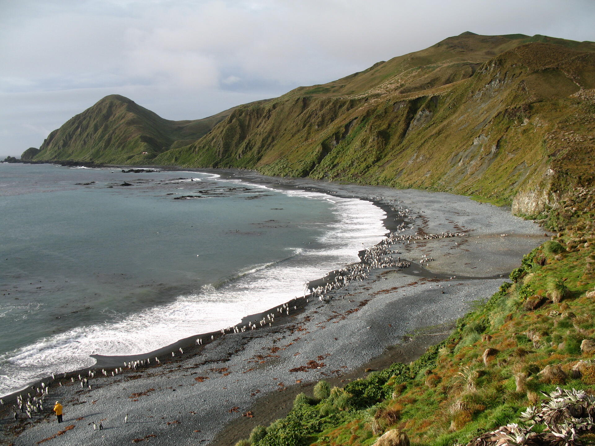
Beyond its geological significance, Macquarie Island is also a sanctuary for an extraordinary array of wildlife. It supports one of the world's largest populations of royal penguins, with the island and its surrounding islets hosting virtually the entire breeding population of the species. King, gentoo, and southern rockhopper penguins also breed on the island. Additionally, it serves as an important breeding ground for numerous seabirds, including southern giant petrels, Antarctic terns, and light-mantled albatrosses.
Marine life is equally abundant, with southern elephant seals and several species of fur seals breeding on the island's shores, while whales, including southern right whales and orcas, are occasionally seen in the surrounding waters. The island's vegetation consists primarily of tussock grasslands, herbfields, heath, bogs, and feldmark, providing habitats for a variety of native plant species, including the large-leaved Macquarie Island cabbage (Stilbocarpa polaris).
Conservation efforts on Macquarie Island are extensive. The island has been protected as a Tasmanian State Reserve since 1978, and one of the world's most ambitious island restoration projects successfully eradicated invasive rabbits, rats, mice, and other introduced animals that had caused severe ecological damage. These measures have enabled native vegetation and wildlife populations to recover while helping to preserve the island's unique ecosystems for future generations.
Today, Macquarie Island stands as a testament to the wonders of nature and science, offering a rare glimpse into the Earth's geological history while nurturing a vibrant and diverse ecosystem. Its designation as a UNESCO World Heritage Site underscores the global importance of preserving this remarkable island and its outstanding natural heritage for future generations.
UNESCO Description of the World Heritage Site
Macquarie Island (34 km long x 5 km wide) is an oceanic island in the Southern Ocean, lying 1,500 km south-east of Tasmania and approximately halfway between Australia and the Antarctic continent. The island is the exposed crest of the undersea Macquarie Ridge, raised to its present position where the Indo-Australian tectonic plate meets the Pacific plate. It is a site of major geoconservation significance, being the only place on earth where rocks from the earth’s mantle (6 km below the ocean floor) are being actively exposed above sea-level. These unique exposures include excellent examples of pillow basalts and other extrusive rocks.
UNESCO Justification of the World Heritage Site
Criterion (vii): Macquarie Island provides an outstanding spectacle of wild, natural beauty with huge congregations of penguins and seals populating what has been described as a small speck thrust up into the vast Southern Ocean. The island lies in latitudes known as the ‘Furious Fifties’ because of the frequency of very strong winds and stormy seas, which have sculpted the island. A coastal terrace supports vast waterlogged and heavily vegetated areas, forming a mire based on deep peat beds known as ‘featherbed’. This is framed by steep escarpments which rise spectacularly to a plateau surface dotted with innumerable lakes, tarns and pools. The continual westerly winds, which increase in force as they rise over the barrier of the island, and changes in topography result in dramatic changes in the vegetation cover which can vary from lush grassland to sparse feldmark within the space of a few metres. Among the most aesthetically appealing features of the island are the vast congregations of wildlife, particularly penguins, during the breeding season. The breeding population of Royal Penguins (Eudyptes schlegeli), a species endemic to Macquarie Island and nearby Bishop and Clerk Islets, is estimated at over 850,000 pairs, one of the greatest congregations of seabirds in the world. The breeding population of King Penguins (Aptenodytes patagonicus), estimated at around 150,000–170,000 breeding pairs in 2000, is still expanding. As the King Penguin chicks do not leave the vicinity of the nest for a year, they survive the rigours of winter by huddling together on the windy and snow-swept beaches. Four species of albatross nest on steep and rugged cliffs and are easily viewed when nesting. Elephant Seals (Mirounga leonina) also form impressive colonies during the breeding season.
Criterion (viii): Macquarie Island and its outlying islets are geologically unique in being the only place on earth where rocks from the earth’s mantle are being actively exposed above sea level. The island is the exposed crest of the undersea Macquarie Ridge, raised to its present position where the Indo-Australian tectonic plate meets the Pacific plate. These unique exposures provide an exceptionally complete section of the structure and composition of both the oceanic crust and the upper mantle, and provide evidence of ‘sea-floor spreading’ and tectonic processes that have operated for hundreds of millions of years. The geological evolution of Macquarie Island began 10 million years ago and continues today with the island experiencing earthquakes and a rapid rate of uplift, all of which are related to active geological processes along the boundary between the two plates. Sequences from all crustal levels, down to 6 kilometres below the ocean floor, are exposed as a result of tilting and differential uplift on Macquarie Island. This provides rare evidence for sequences that are common from the bottom of the oceans to the upper mantle, but not seen elsewhere in surface outcrops. The lack of deformation of this exposed crust is highly significant as it exhibits key interrelated and interdependent oceanic crustal elements in their natural relationship. Macquarie Island is the only ophiolite (a well-developed and studied geological complex) recognised to have been formed within a major ocean basin. The geology of the island is therefore considered to be the connecting link between the ophiolites of continental environments and those located within the oceanic crust.
Encyclopedia Record: Macquarie Island
Macquarie Island is a subantarctic island in the south-western Pacific Ocean, about halfway between New Zealand and Antarctica. It has been governed as a part of Tasmania, Australia, since 1880. It became a Tasmanian State Reserve in 1978 and was inscribed as a UNESCO World Heritage Site in 1997.Additional Site Details
Area: 557,280 hectares
Number of Components: 1
(viii) — Outstanding example representing major earth stages
Coordinates: -54.59472222 , 158.8955556
IUCN World Heritage Outlook
The 2025 Conservation Outlook on Macquarie Island reports the following assessment:
Source: International Union for Conservation of Nature (IUCN) · View assessment
Image
M. Murphy, Public domain
