World Heritage Identification Number: 1386
World Heritage since: 2012
Category: Mixed Cultural Heritage and Natural Heritage
WHE Type: Natural Landscapes & Geographic Features
Transboundary Heritage: No
Endangered Heritage: No
Country: 🇵🇼 Palau
Continent: Oceania
UNESCO World Region: Asia and the Pacific
Map
A Journey Through the Enchanting Rock Islands Southern Lagoon
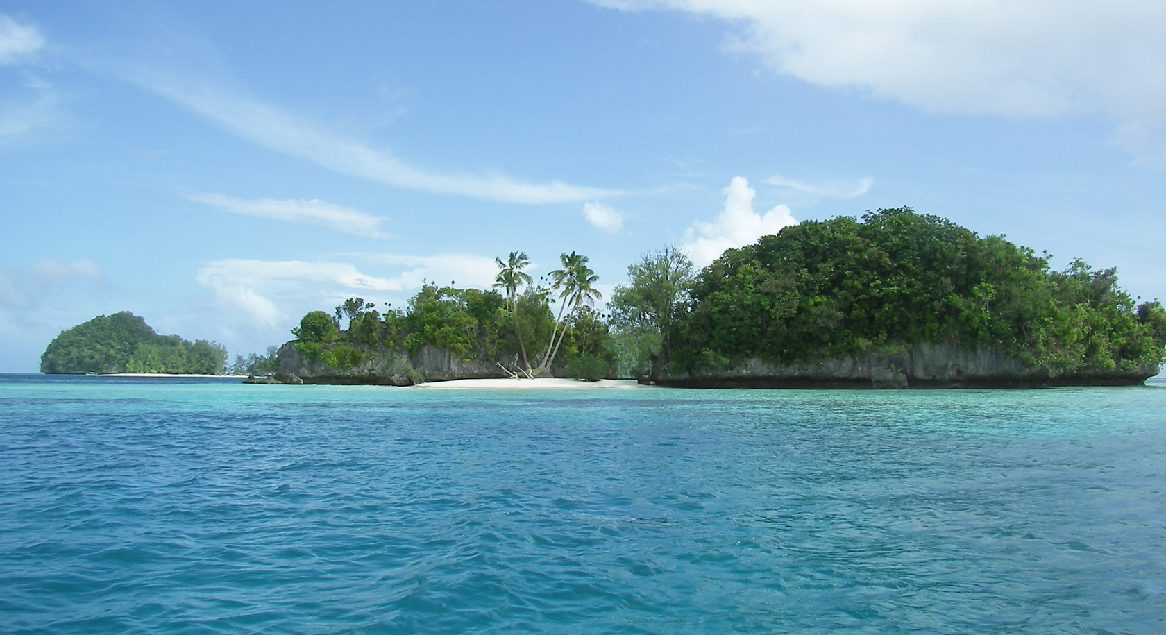
The Rock Islands Southern Lagoon, a mesmerizing expanse of crystal-clear waters teeming with vibrant marine life, lies nestled within the heart of Palau's archipelago. This captivating UNESCO World Heritage Site, covering an impressive 100,200 hectares, is home to 445 uninhabited limestone islands of volcanic origin, each boasting a unique, mushroom-like shape that stands tall amidst the turquoise lagoons surrounded by coral reefs.
More to come…UNESCO Description of the World Heritage Site
Rock Islands Southern Lagoon covers 100,200 ha and includes 445 uninhabited limestone islands of volcanic origin. Many of them display unique mushroom-like shapes in turquoise lagoons surrounded by coral reefs. The aesthetic beauty of the site is heightened by a complex reef system featuring over 385 coral species and different types of habitat. They sustain a large diversity of plants, birds and marine life including dugong and at least thirteen shark species. The site harbours the highest concentration of marine lakes anywhere, isolated bodies of seawater separated from the ocean by land barriers. They are among the islands’ distinctive features and sustain high endemism of populations which continue to yield new species discoveries. The remains of stonework villages, as well as burial sites and rock art, bear testimony to the organization of small island communities over some three millennia. The abandonment of the villages in the 17th and 18th centuries illustrates the consequences of climate change, population growth and subsistence behaviour on a society living in a marginal marine environment.
UNESCO Justification of the World Heritage Site
Criterion (iii): The Rock Islands cave deposits, burials, rock art, abandoned remains of stonework villages and middens bear exceptional testimony to the organisation of small island communities and their harvesting of marine resources over some three millennia.
Criterion (v): The abandonment of Rock Island villages in the 17th and 18th centuries demonstrated by the remains of human settlement and evidence of marine harvesting activity in the Rock Islands Southern Lagoon is an exceptional illustration of the intersection and consequences of climate change, population growth, and subsistence behaviour on a society living in a marginal marine environment.
Criterion (vii): The Rock Islands Southern Lagoon contains an exceptional variety of habitats within a relatively limited area. Barrier and fringing reefs, channels, tunnels, caves, arches, and coves, as well as the highest number and density of marine lakes in the world, are home to diverse and abundant marine life. The maze of dome-shaped and green Rock Islands seemingly floating in the turquoise lagoon surrounded by coral reef is of exceptional aesthetic beauty.
Criterion (ix): The Rock Islands Southern Lagoon contains 52 marine lakes, more than at any other site in the world. Furthermore, the marine lakes of the property are at different stages of geological and ecological development, ranging from lakes with high connectivity to the sea to highly isolated lakes with notably different species composition, including unique and endemic species. These features represent an outstanding example of how marine ecosystems and communities develop, and make the lakes valuable as “natural laboratories” for scientific study of evolution and speciation. Five new subspecies of the Mastigias papua jellyfish have been described from these marine lakes, and new species discoveries continue to be made both in the marine lakes as well as in the complex reef habitats of the property.
Criterion (x): The Rock Islands Southern Lagoon has exceptionally high biological and marine habitat diversity. The marine lakes are unique in terms of number, the density at which they occur, and their varying physical conditions. With low fishing pressure, limited pollution and human impact, as well as an exceptional variety of reef habitat, the resilience of reefs of the property makes it a critical area for protection, including as an area important for climate change adaptation of reef biota, and potentially as a source of larvae for reefs in the region. All the endangered megafauna of Palau, 746 species of fish, over 385 species of corals, at least 13 species of sharks and manta rays, 7 species of giant clams, and the endemic nautilus are found in the property, and the forests of the islands include all of Palau’s endemic birds, mammals, herpetofauna and nearly half of Palau’s endemic plants. This makes the area of exceptional conservation value.
Encyclopedia Record: Rock Islands
The Rock Islands of Palau, also called Chelbacheb, are a collection of several hundred small limestone or coral uprises in the Southern Lagoon of Palau between Koror and Peleliu, now an incorporated part of Koror State. There are between 250 and 300 islands in the group according to different sources, with an aggregate area of 42 square kilometers (16 sq mi) and a maximum height of 207 meters (679 ft). The islands were declared a UNESCO World Heritage Site in 2012.Additional Site Details
Area: 100,200 hectares
Number of Components: 1
(v) — Outstanding example of traditional human settlement
(vii) — Contains superlative natural phenomena or beauty
(ix) — Outstanding example representing ecological and biological processes
(x) — Contains most important habitats for biodiversity
Coordinates: 7.246925 , 134.3525
IUCN World Heritage Outlook
The 2025 Conservation Outlook on Rock Islands Southern Lagoon reports the following assessment:
Source: International Union for Conservation of Nature (IUCN) · View assessment
Image
Peter R. Binter (=Binter); The original uploader was Binter at German Wikipedia. (Original text: Peter Binter), Public domain
