World Heritage Identification Number: 968
World Heritage since: 2000
Category: Cultural Heritage
WHE Type: Agriculture Landscapes, Parks & Gardens
Transboundary Heritage: No
Endangered Heritage: No
Country: 🇸🇪 Sweden
Continent: Europe
UNESCO World Region: Europe and North America
Map
The Agricultural Landscape of Southern Öland: A Unique Cultural and Natural Landscape in Sweden
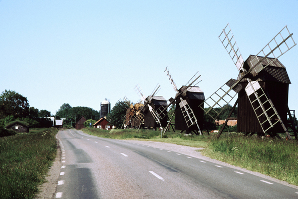
The Agricultural Landscape of Southern Öland, inscribed as a UNESCO World Heritage Site in 2000, is a remarkable testament to human adaptation and resilience in one of the most challenging environments in Europe. Located on the island of Öland, off the southeastern coast of Sweden, this expansive region spans over 56,000 hectares, making it a significant cultural and natural landmark.
More to come…UNESCO Description of the World Heritage Site
The southern part of the island of Öland in the Baltic Sea is dominated by a vast limestone plateau. Human beings have lived here for some five thousand years and adapted their way of life to the physical constraints of the island. As a consequence, the landscape is unique, with abundant evidence of continuous human settlement from prehistoric times to the present day.
UNESCO Justification of the World Heritage Site
Criterion (iv): The landscape of Southern Öland takes its contemporary form from its long cultural history, adapting to the physical constraints of the geology and topography.
Criterion (v): Southern Öland is an outstanding example of human settlement, making the optimum use of diverse landscape types on a single island.
Encyclopedia Record: Agricultural landscape of southern Öland
The agricultural landscape of southern Öland is an area of more than 56,000 hectares located on the island of Öland, Sweden. It includes Stora alvaret, a limestone plateau of around half that surface. Stora alvaret is a dagger-shaped area almost 40 km (25 mi) long and about 10 km (6.2 mi) at its widest north end. This limestone plain, around a quarter of the surface of the island, is the most extended of its kind in Europe. As a result of the thin layer of soil and high pH levels, it presents a wide range of plants, including many rare species.Additional Site Details
Area: 56,323 hectares
Number of Components: 1
(v) — Outstanding example of traditional human settlement
Coordinates: 56.325 , 16.48333
Image
© No machine-readable author provided. Wigulf~commonswiki assumed (based on copyright claims)., CC BY-SA 3.0 Resized from original. (This derivative is under the same CC BY-SA license.)
