
Gros Morne National Park


World Heritage Identification Number: 419

World Heritage since: 1987

Category: Natural Heritage

WHE Type: Protected Areas & National Parks

Transboundary Heritage: No

Endangered Heritage: No

Country: 🇨🇦 Canada

Continent: Americas

UNESCO World Region: Europe and North America

Map

Exploring the Geological Marvel: Gros Morne National Park

Gros Morne National Park, a 1,805 km² expanse situated on the west coast of Newfoundland, Canada, stands as a testament to the intriguing process of continental drift. Established in 1977 and designated as a UNESCO World Heritage Site in 1987, this park offers a unique opportunity to witness the exposure of deep ocean crust and the rocks from the Earth's mantle.

More to come…

UNESCO Description of the World Heritage Site

Situated on the west coast of the island of Newfoundland, the park provides a rare example of the process of continental drift, where deep ocean crust and the rocks of the earth's mantle lie exposed. More recent glacial action has resulted in some spectacular scenery, with coastal lowland, alpine plateau, fjords, glacial valleys, sheer cliffs, waterfalls and many pristine lakes.

UNESCO Justification of the World Heritage Site

Criterion (vii): Gros Morne National Park, an outstanding wilderness environment of spectacular landlocked, freshwater fjords and glacier-scoured headlands in an ocean setting, is an area of exceptional natural beauty.

Criterion (viii): The rocks of Gros Morne National Park collectively present an internationally significant illustration of the process of continental drift along the eastern coast of North America and contribute greatly to the body of knowledge and understanding of plate tectonics and the geological evolution of ancient mountain belts. In glacier-scoured highlands and spectacular fjords, glaciation has made visible the park’s many geological features.

Encyclopedia Record: Gros Morne National Park

Gros Morne National Park is a Canadian national park and World Heritage Site located on the west coast of Newfoundland. At 1,805 km2 (697 sq mi), it is the second largest national park in Atlantic Canada after Torngat Mountains National Park, which has an area of 9,700 km2 (3,700 sq mi).

Read more on Wikipedia

Additional Site Details

Area: 180,500 hectares

Number of Components: 1

UNESCO Criteria: (vii) — Contains superlative natural phenomena or beauty
(viii) — Outstanding example representing major earth stages

Coordinates: 49.6125 , -57.53138889

IUCN World Heritage Outlook

The 2025 Conservation Outlook on Gros Morne National Park reports the following assessment:

Good with some concerns

Source: International Union for Conservation of Nature (IUCN) · View assessment

Image
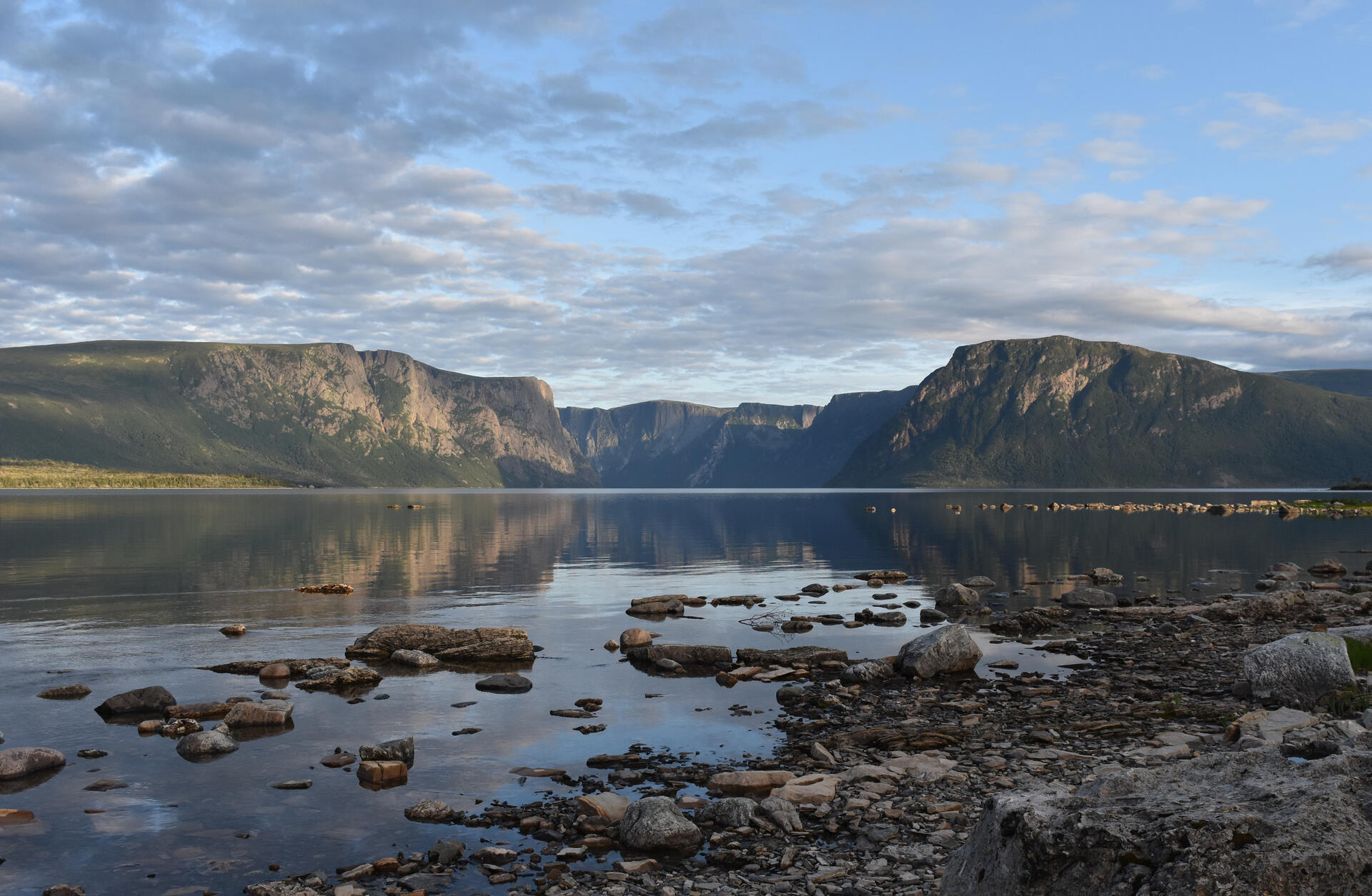
Image of Gros Morne National Park

© Adavyd, CC BY-SA 4.0 Resized from original. (This derivative is under the same CC BY-SA license.)

World Heritage Research

Discover scientific research and academic studies that deepen our understanding of Gros Morne National Park from its history and significance to its conservation, management, and contemporary challenges.

  • Tracking rapid landscape change with repeated photography, Gros Morne National Park, Canada

    A long-term photographic study of Gros Morne National Park, Canada, reveals that most high-risk landslide sites along Western Brook Pond remain stable, while thin-skinned landslides near Winter House Brook have persisted for over a century. The research used repeated imagery to document landscape changes—such as stone rings, coastal dynamics, and river modifications—driven primarily by natural forces like gravity, precipitation, and frost heaving rather than human activity. This non-invasive method offers valuable insights into ecological integrity, public safety, and landscape processes, with minimal cost or environmental impact.

    Berger, A. (2017). Tracking rapid landscape change with repeated photography, Gros Morne National Park, Canada. Atlantic Geology, 53, 115–126. https://doi.org/10.4138/atlgeol.2017.005

    View Publication Record | Read Publication
  • Leisure and the Net Opportunity Cost of Travel Time in Recreation Demand Analysis: An Application to Gros Morne National Park

    Research reveals that visitors to Gros Morne National Park, a remote UNESCO World Heritage Site, value recreational access with a lower opportunity cost of travel time relative to their wage rate compared to previous studies. This finding challenges conventional assumptions by endogenously estimating the fraction of hourly earnings that best represents this cost, rather than imposing it exogenously. The study employs advanced count data models accounting for zero-truncation and overdispersion, providing a nuanced understanding of consumer surplus in park visitation. By linking visitor characteristics to opportunity costs, the research offers new insights into recreational demand analysis, particularly for remote sites.

    Amoako-Tuffour, J., & Martínez-Espiñeira, R. (2012). Leisure and the Net Opportunity Cost of Travel Time in Recreation Demand Analysis: An Application to Gros Morne National Park. Journal of Applied Economics, 15(1), 25–49. https://doi.org/10.1016/s1514-0326(12)60002-6

    View Publication Record | Read Publication
  • Trichomycetes from Newfoundland, including Gros Morne National Park

    Research in Gros Morne National Park, Newfoundland, has uncovered three new species of Trichomycetes fungi—Smittium colboi, Smittium georgense, and Stachylina forantipes—alongside six additional species representing new geographic records for the region. Notably, Spartiella barbata is reported in North America for the first time. The study analyzed aquatic insects from coastal sites across Newfoundland, revealing diverse fungal taxa with taxonomic significance, including detailed observations of Pennella hovassi. This work expands the known biodiversity of Trichomycetes in Atlantic Canada and provides critical insights into their ecological distribution.

    Strongman, D. B. (2010). Trichomycetes from Newfoundland, including Gros Morne National Park. Botany, 88(12), 1011–1022. https://doi.org/10.1139/b10-073

    View Publication Record | Read Publication

About World Heritage Explorer

World Heritage Explorer is an independent educational project designed to uncover and share the richness of our world’s cultural and natural heritage. Dive into detailed site profiles, immersive imagery, interactive maps, and tools that help you explore UNESCO World Heritage Sites across the globe. Drawing extensively on open data sources, the project delivers authoritative, well-structured information for learners, educators, travelers, and younger explorers alike.

Learn more about the project

Nearby World Heritage Sites

Red Bay Basque Whaling Station
248 km — Canada
L’Anse aux Meadows National Historic Site
260 km — Canada
Anticosti
412 km — Canada
Mistaken Point
461 km — Canada
Miguasha National Park
666 km — Canada
Flag of Canada

Canada and the World Heritage Convention

State Party since: July 23, 1976

Status: Acceptance

Mandates to the World Heritage Committee: 1976-1978, 1985-1991, 1995-2001, 2005-2009

Total of Mandate Years: 18

Total of Mandates: 4

WHC Electoral Group: I (Western Europe/North America)

Learn more about Canada

Weather at the World Heritage Site

Last updated: September 8, 2026

Portions of the page Gros Morne National Park are based on data from UNESCO — World Heritage List Dataset and on text from the Wikipedia article Gros Morne National Park, licensed under CC BY-SA 4.0. Changes made. Additional original content by World Heritage Explorer (WHE), licensed under CC BY-SA 4.0. WHE is not affiliated with UNESCO or the World Heritage Committee. Legal Notice. Privacy Policy.

Open Data for an Open World