World Heritage Identification Number: 543
World Heritage since: 1990
Category: Cultural Heritage
WHE Type: Historic Cities & Urban Areas
Transboundary Heritage: No
Endangered Heritage: No
Country: 🇺🇿 Uzbekistan
Continent: Asia
UNESCO World Region: Asia and the Pacific
Map
Exploring the Ancient Walls of Itchan Kala: A Journey Through the Heart of Khiva, Uzbekistan
Itchan Kala, meaning 'inner town' in Uzbek, is the heart of the ancient city of Khiva, located in modern-day Uzbekistan. This fortified citadel, enclosed within towering brick walls up to 10 meters high, serves as a testament to the rich history and architectural prowess of Central Asia. In 1990, UNESCO recognized Itchan Kala as a World Heritage Site, acknowledging its significance as a well-preserved example of Islamic architecture in the region.
The origins of Itchan Kala date back more than 2,500 years, when nomadic tribes settled in the Khiva oasis. However, the city as it appears today took shape during the reign of the Khanate of Khiva, which flourished from the 16th to the 20th centuries. The city's strategic location along the Silk Road made it a crucial stopover for traders traveling between China, India, Persia, and Europe.
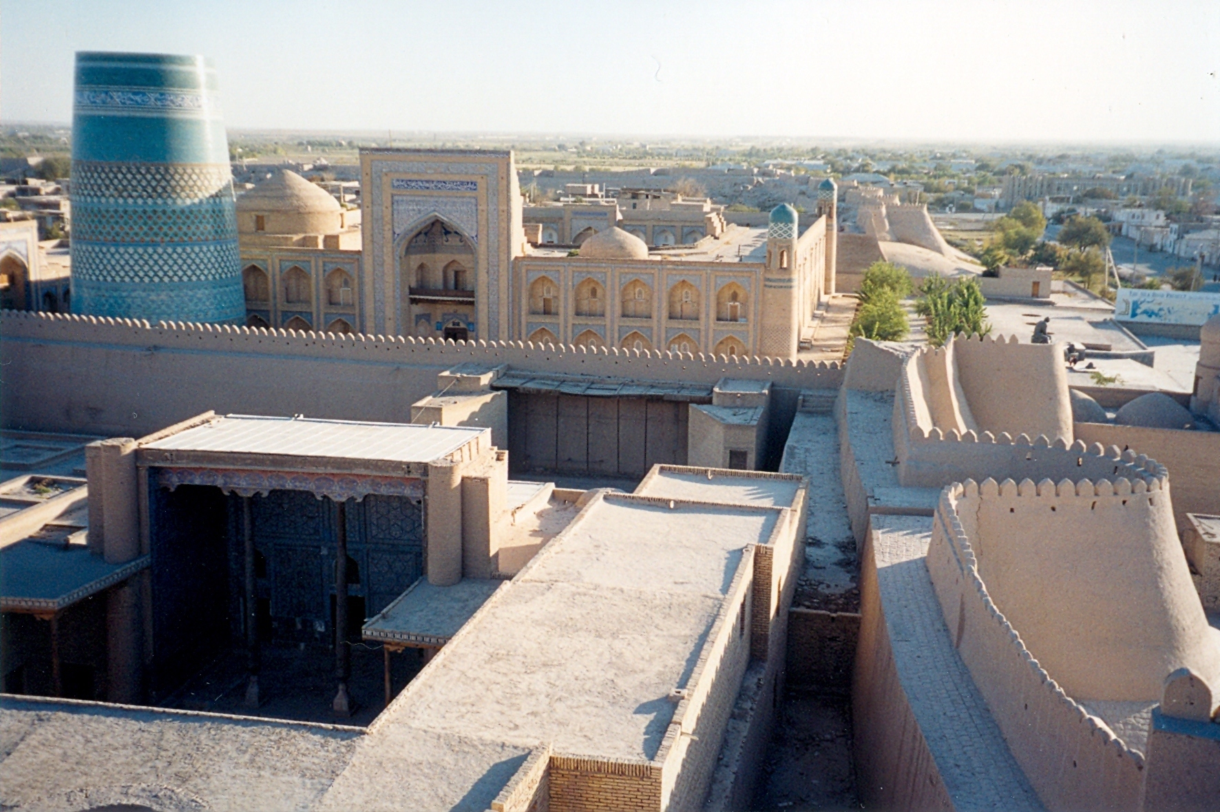
One of the most striking features of Itchan Kala is its imposing defensive walls. These walls, constructed from mud bricks and gypsum, were designed to protect the city from invaders. They encircle the entire old town, creating a labyrinthine network of narrow streets and courtyards that reveal a wealth of historical and cultural treasures. Within these fortifications lies a collection of over 50 historic monuments and 250 old houses.
Within these walls lies a collection of remarkable buildings, including the Djuma Mosque, one of the oldest and most significant religious sites in the city. Originally founded in the 10th century and largely reconstructed in the late 18th century, this mosque is famous for its flat roof supported by 213 carved wooden columns. Standing over 56 meters, the Islam Khodja Minaret, the tallest minaret in Khiva offers breathtaking panoramic views of the citadel upon climbing its spiral staircase. Its alternating bands of dark green and blue tiles make it the most recognizable landmark in the city.
Itchan Kala is also home to numerous mausoleums, madrasas, and palaces. Among them, the mausoleums of Pahlavan Mahmud and Muhammad Amin Khan stand out. The former houses the remains of Pahlavan Mahmud, a legendary hero known for his extraordinary strength and bravery, while the latter is the final resting place of Muhammad Amin Khan, who ruled Khiva from 1845 to 1855. His reign was cut short in battle, leaving the iconic, turquoise-tiled Kalta Minor Minaret famously unfinished.
Among the palaces, Tash-Khauli (the Stone House), built in the 1830s by Alla-Kulli-Khan, showcases the peak of Khivan decorative art. Its courtyards are adorned with elaborate blue-and-white majolica tiles, intricate wood carvings, and delicate stucco.
Overall, Itchan Kala provides visitors a captivating glimpse into the past and unparalleled insight into the culture, history, and architecture of Central Asia. Its designation as a UNESCO World Heritage Site is well-deserved, ensuring the preservation of this unique and enchanting destination for generations to come.
UNESCO Description of the World Heritage Site
Itchan Kala is the inner town (protected by brick walls some 10 m high) of the old Khiva oasis, which was the last resting-place of caravans before crossing the desert to Iran. Although few very old monuments still remain, it is a coherent and well-preserved example of the Muslim architecture of Central Asia. There are several outstanding structures such as the Djuma Mosque, the mausoleums and the madrasas and the two magnificent palaces built at the beginning of the 19th century by Alla-Kulli-Khan.
UNESCO Justification of the World Heritage Site
Criterion (iii) : Withthe coherent and well preserved urban ensemble of the inner town of Khiva, Itchan Kala bears exceptional testimony to the lost civilizations of Khorezm.
Criterion (iv) : Several monuments of Itchan Kala constitute remarkable and unique types of architectural ensembles, built according to the ancient traditions of Central Asia, which illustrate the development of Islamic architecture between the 14th to the 19th century.
Criterion (v) : The domestic architecture of Khiva, with traditional architectural style, represents an important example of human settlements in Central Asia by virtue of its design and construction.
Encyclopedia Record: Itchan Kala
Itchan Kala is the walled inner town of the city of Khiva, Uzbekistan. Since 1990, it has been protected as a World Heritage Site.Additional Site Details
Area: 37.5 hectares
Number of Components: 1
(iv) — Outstanding example of a type of building or landscape
(v) — Outstanding example of traditional human settlement
Coordinates: 41.378088 , 60.360253
Image
© Doron, CC BY-SA 3.0 Resized from original. (This derivative is under the same CC BY-SA license.)
