World Heritage Identification Number: 1404
World Heritage since: 2012
Category: Cultural Heritage
WHE Type: Cultural Landscapes
Transboundary Heritage: No
Endangered Heritage: No
Country: 🇨🇦 Canada
Continent: Americas
UNESCO World Region: Europe and North America
Map
The Landscape of Grand Pré: A Cultural Testimony of Adaptation and Resilience
The Landscape of Grand Pré, located in the southern Minas Basin of Nova Scotia, Canada, stands as a remarkable testament to human resilience, innovation, and cultural preservation. Inscribed as a UNESCO World Heritage Site in 2012, this expansive marshland and archaeological site offers a unique glimpse into the history of the Acadians, their descendants, and the subsequent Planters who adapted to the challenging environmental conditions of the North American Atlantic coast.
More to come…UNESCO Description of the World Heritage Site
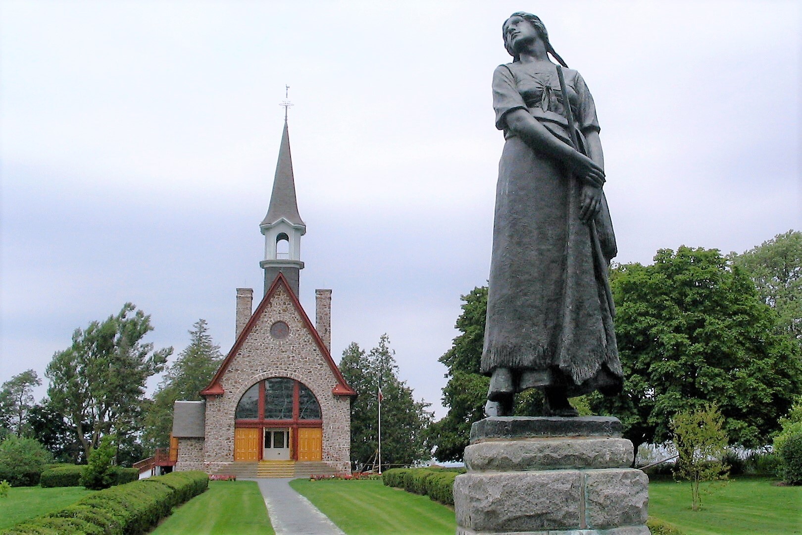
Situated in the southern Minas Basin of Nova Scotia, the Grand Pré marshland and archaeological sites constitute a cultural landscape bearing testimony to the development of agricultural farmland using dykes and the aboiteau wooden sluice system, started by the Acadians in the 17th century and further developed and maintained by the Planters and present-day inhabitants. Over 1,300 ha, the cultural landscape encompasses a large expanse of polder farmland and archaeological elements of the towns of Grand Pré and Hortonville, which were built by the Acadians and their successors. The landscape is an exceptional example of the adaptation of the first European settlers to the conditions of the North American Atlantic coast. The site – marked by one of the most extreme tidal ranges in the world, averaging 11.6 m – is also inscribed as a memorial to Acadian way of life and deportation, which started in 1755, known as the Grand Dérangement.
UNESCO Justification of the World Heritage Site
Criterion (v): The cultural landscape of Grand Pré bears exceptional testimony to a traditional farming settlement created in the 17th century by the Acadians in a coastal zone with tides that are among the highest in the world. The polderisation used traditional techniques of dykes, aboiteaux and a drainage network, as well as a community-based management system still in use today. The resultant rich alluvial soil enabled continuous and sustainable agricultural development.
Criterion (vi): Grand Pré is the iconic place of remembrance of the Acadian diaspora, dispersed by the Grand Dérangement, in the second half of the 18th century. Its polder landscape and archaeological remains are testimony to the values of a culture of pioneers able to create their own territory, whilst living in harmony with the native Mi’kmaq people. Its memorial constructions form the centre of the symbolic re-appropriation of the land of their origins by the Acadians, in the 20th century, in a spirit of peace and cultural sharing with the English-speaking community.
Encyclopedia Record: Grand-Pré, Nova Scotia
Grand-Pré is a rural community in Kings County, Nova Scotia, Canada. Its French name translates to "Great/Large Meadow" and the community lies at the eastern edge of the Annapolis Valley several kilometres east of the town of Wolfville on a peninsula jutting into the Minas Basin surrounded by extensive dyked farm fields, framed by the Gaspereau and Cornwallis Rivers. The community was made famous by Henry Wadsworth Longfellow's poem Evangeline and is today home to the Grand-Pré National Historic Site. On June 30, 2012, the Landscape of Grand-Pré was named a World Heritage Site by UNESCO.Additional Site Details
Area: 1,323.24 hectares
Number of Components: 1
(vi) — Directly associated with events or living traditions
Coordinates: 45.1183333333 , -64.3072222222