World Heritage Identification Number: 145
World Heritage since: 1981
Category: Natural Heritage
WHE Type: Protected Areas & National Parks
Transboundary Heritage: No
Endangered Heritage: No
Country: 🇦🇷 Argentina
Continent: Americas
UNESCO World Region: Latin America and the Caribbean
Map
Los Glaciares National Park: A Landscape of Ice and Stone in Patagonia
Los Glaciares National Park, located in the southwestern region of Santa Cruz Province, Argentina, is a breathtaking expanse of ice, stone, and water that offers visitors a glimpse into one of the most pristine and remote landscapes on Earth. Established in 1937, this national park was designated a UNESCO World Heritage Site in 1981 due to its exceptional natural beauty and outstanding geological significance.
Covering an area of approximately 7,269 square kilometers, Los Glaciares National Park is home to some of the world's most impressive glaciers, including Perito Moreno, Upsala, and Spegazzini. These massive ice formations originate from the Southern Patagonian Ice Field, one of the largest ice masses outside Antarctica and Greenland and the largest in the Southern Hemisphere beyond Antarctica.
One of the most iconic sights within the park is the Perito Moreno Glacier, which covers approximately 250 square kilometers and terminates in Lago Argentino. Rising up to about 70 meters above the surface of the lake, this spectacular glacier is renowned for its dynamic nature and frequent calving events, during which enormous blocks of ice break away and crash into the water below. Visitors can observe this remarkable phenomenon from an extensive network of viewing platforms and walkways.
The park also contains numerous glacial lakes that contribute to its dramatic scenery. The largest of these is Lago Argentino, Argentina's largest freshwater lake, whose turquoise waters are fed by glaciers descending from the Patagonian Ice Field. Several major glaciers, including Perito Moreno, Upsala, and Spegazzini, flow into the lake, creating a constantly changing landscape of floating icebergs and glacial vistas.
The park’s glaciers and high mountain snowfields generate a network of rivers and meltwater streams that shape much of the surrounding landscape. During the warmer months, increased melting gives rise to seasonal waterfalls that cascade down rocky valleys and cliffs, especially in areas near the Andean foothills. These waterways carry fine glacial sediments into lakes such as Lago Argentino, contributing to their distinctive turquoise color and constantly changing appearance.
Beyond its glaciers and lakes, Los Glaciares National Park is renowned for its rugged mountain scenery. In the northern section of the park rise the granite peaks of Cerro Fitz Roy and Cerro Torre, which attract climbers and hikers from around the world. These dramatic mountains, shaped by millions of years of geological processes, are among the most recognizable landmarks in Patagonia.
The park also supports a rich variety of plant and animal life. Its ecosystems range from Andean forests dominated by lenga and ñire trees to Patagonian steppe grasslands. Wildlife found within the park includes guanacos, pumas, Andean condors, foxes, and numerous bird species. Although many of these animals are elusive, patient visitors may be fortunate enough to observe them in their natural habitats.
Long before the establishment of the national park, the region was inhabited by Indigenous peoples, including the Aonikenk (Tehuelche), who adapted to the harsh Patagonian environment for thousands of years. Their presence is still reflected in archaeological sites, rock art, and place names throughout the wider region of Patagonia. Although the landscape is often viewed today as remote and untouched, it has a deep human history tied to traditional hunting routes and seasonal movement across the steppe and mountain valleys.
Los Glaciares National Park is accessible through several gateways, the most popular being the towns of El Calafate and El Chaltén. Visitors can reach the park via Argentina's road network, including the famous Ruta Nacional 40. A wide range of accommodations, from luxury hotels to campsites, is available in nearby communities, making the park accessible to travelers with varying interests and budgets.
The park is also an important site for scientific research, particularly in the study of climate change and glacial dynamics. The park’s glaciers are closely monitored because they respond sensitively to variations in temperature and precipitation. While some glaciers, such as Perito Moreno, have shown unusual periods of relative stability compared to others in the region, the majority of glaciers in the Southern Patagonian Ice Field are currently retreating, providing valuable data on the long-term impacts of global warming on Southern Hemisphere ice systems.
Today, Los Glaciares National Park remains one of South America's most celebrated natural destinations. Its towering glaciers, pristine lakes, dramatic mountain peaks, and diverse wildlife combine to create an unforgettable experience. As one of the world's most remarkable protected landscapes, the park serves as a powerful reminder of the beauty, scale, and fragility of the natural world.
UNESCO Description of the World Heritage Site
The Los Glaciares National Park is an area of exceptional natural beauty, with rugged, towering mountains and numerous glacial lakes, including Lake Argentino, which is 160 km long. At its farthest end, three glaciers meet to dump their effluvia into the milky grey glacial water, launching massive igloo icebergs into the lake with thunderous splashes.
UNESCO Justification of the World Heritage Site
Criterion (vii) : Los Glaciares National Park is embedded into the enchanted and remote mountain landscape of the Patagonian Andes shared by Argentina and Chile. Dominated by rugged granite peaks exceeding 3000 m.a.s.l. the landscape is modelled by massive, ongoing glaciations. About half of the large property is covered by numerous glaciers, many of which belong to South America's largest ice field. Despite the name's focus on the impressive glaciers there is a remarkable landscape diversity encompassing a large altitudinal gradient of more than 3000 metres and very diverse ecosystems. The glaciers feed the huge mountain lakes of Viedma and Argentino. The overwhelming beauty of the landscape is epitomized where the Perito Moreno Glacier meets Lake Argentino. The vast front of the slowly and constantly moving glacier, up to 60 metres high, regularly calves bluish icebergs into the waters of Lake Argentino, an audiovisual spectacle attracting visitors from all over the world.
Criterion (viii) : Los Glaciares National Park is an excellent example of the significant process of glaciation, as well as of geological, geomorphic and physiographic phenomena caused by the ongoing advance and retreat of the glaciations that took place during the Pleistocene epoch in the Quaternary period, and the neoglaciations corresponding to the current epoch or Holocene. These events have modelled – and continue to model the landscape of the area and may be recognised by the lacustrine basins of glacial origin, the moraine systems deposited on the plateaux, or by more recent systems pertaining to the current valleys, and, the many large glacier tongues fed by the Ice Fields of the Andes. The property also provides fertile ground for scientific research on climate change.
Encyclopedia Record: Los Glaciares National Park
Los Glaciares National Park is a federal protected area in Santa Cruz Province, Argentina.Additional Site Details
Area: 726,927 hectares
Number of Components: 1
(viii) — Outstanding example representing major earth stages
Coordinates: -50 , -73.24944
IUCN World Heritage Outlook
The 2025 Conservation Outlook on Los Glaciares National Park reports the following assessment:
Source: International Union for Conservation of Nature (IUCN) · View assessment
Image
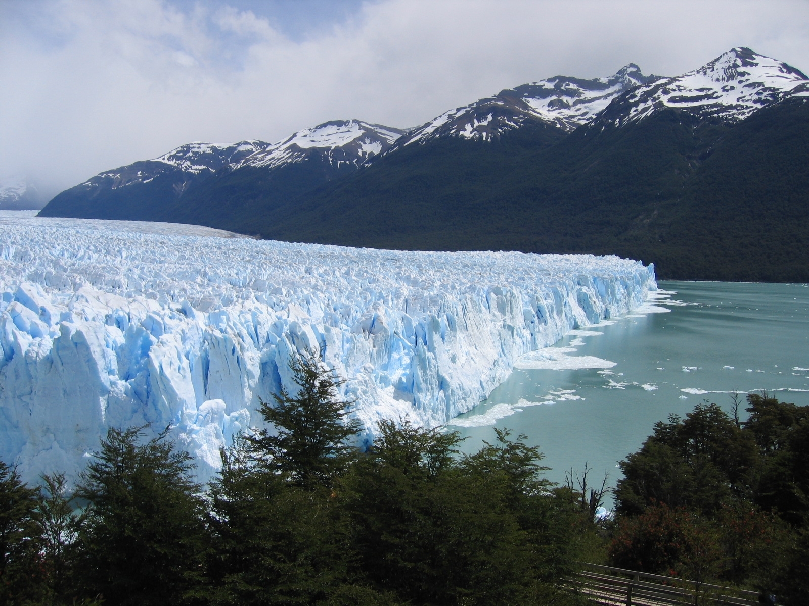
© Emesbe at Dutch Wikipedia, CC BY-SA 3.0 Resized from original. (This derivative is under the same CC BY-SA license.)
World Heritage Research
Discover scientific research and academic studies that deepen our understanding of Los Glaciares National Park from its history and significance to its conservation, management, and contemporary challenges.
-
Landslide susceptibility mapping in the Northern part of Los Glaciares National Park, Southern Patagonia, Argentina using remote sensing, GIS and frequency ratio model
A high-accuracy Landslide Susceptibility Map (LSM) for the northern part of Los Glaciares National Park reveals that geomorphology, land cover, lithology, and elevation are the most critical factors influencing slope instability in deglaciated environments. The study, using remote sensing, GIS analysis, and a Frequency Ratio Model (FRM), identified Quaternary deposits, ice-contact topography, and innermost lateral moraines as particularly prone to landslides, including moraine collapses, debris flows, and rockfalls. With an AUC accuracy of 0.804, the LSM provides actionable insights for hazard management in this glacier-shrinking region, aiding infrastructure protection for residents and tourists.
Moragues, S., Lenzano, M. G., Jeanneret, P., Gil, V., & Lannutti, E. (2024). Landslide susceptibility mapping in the Northern part of Los Glaciares National Park, Southern Patagonia, Argentina using remote sensing, GIS and frequency ratio model. Quaternary Science Advances, 13, 100146. https://doi.org/10.1016/j.qsa.2023.100146
View Publication Record | Read Publication -
“Andás con tu límite por fuera” . Conflictos jurisdiccionales y descontrol territorial en los Parques Nacionales Los Glaciares y Perito Moreno (Argentina)
Territorial ambiguity within Los Glaciares and Perito Moreno National Parks has weakened institutional control, enabling neoliberal conservation practices to expand. This study reveals that conflicting laws and jurisdictional disputes between national parks and Santa Cruz provincial authorities have led to a lack of regulatory oversight, facilitating commercial encroachment in these protected areas. Researchers analyzed legal documents, conducted interviews, and observed park activities to demonstrate how normative ambiguity has diminished institutional power and allowed the advancement of neoliberal conservation frontiers, particularly in Los Glaciares National Park.
Ponzi, B. S.,. (2023). “Andás con tu límite por fuera” . Conflictos jurisdiccionales y descontrol territorial en los Parques Nacionales Los Glaciares y Perito Moreno (Argentina). Huellas, 27(2), 79–99. https://doi.org/10.19137/huellas-2023-2717
View Publication Record | Read Publication -
Structure, seismostratigraphy, and tectonic evolution of Lago Roca (southern Patagonia, Argentina)
A comprehensive seismic survey of Lago Roca, located within the UNESCO World Heritage Site Los Glaciares National Park, reveals the lake's structural asymmetry and tectonic activity. The study identifies two sub-basins separated by a central basement high with a pop-up structure, bounded by NE–SW trending strike-slip faults linked to the regional 'Lago Argentino transfer fault.' This active fault segment, confirmed by shallow seismicity, has deformed the lake's sedimentary infill and created subsidiary normal faults. The findings suggest Lago Roca is a pull-apart basin typical of transform margins, with its evolution modeled based on seismic data and regional tectonics.
Lozano, J. G., Gutierrez, Y. S., Bran, D. M., Lodolo, E., Cerredo, M. E., Tassone, A., & Vilas, J. F. (2022). Structure, seismostratigraphy, and tectonic evolution of Lago Roca (southern Patagonia, Argentina). Geological Journal, 57(8), 3101–3113. Portico. https://doi.org/10.1002/gj.4454
View Publication Record | Read Publication -
Caracterización y reconstrucción del deslizamiento Agassiz mediante el uso de datos geoespaciales. Patagonia Austral, Argentina
A large rotational landslide, involving soil and moraine material, occurred on February 10, 2013, on the western slope of Upsala Channel in Los Glaciares National Park, Argentina. This event was linked to the retreat of the Upsala Glacier, which induced slope relaxation and instability. The study reconstructed the landslide using geo-spatial data, including satellite imagery, digital elevation models, historical photographs, bathymetric data, and park ranger accounts. Conditioning factors included unconsolidated moraine material, steep east-facing slopes prone to solar heating, and soil creep processes. Potential triggers were sediment saturation from runoff or rainfall, glacial erosion, and seismic activity. The slope exhibited instability for over 20 years prior to the landslide, suggesting ongoing risk.
Moragues, S. N., Lenzano, M. G., Rivera, S. A., Oberreuter, J. G., & Vich, A. (2021). Caracterización y reconstrucción del deslizamiento Agassiz mediante el uso de datos geoespaciales. Patagonia Austral, Argentina. Andean Geology, 48(3), 557. https://doi.org/10.5027/andgeov48n3-3350
View Publication Record | Read Publication -
The Patagonian Sublime: The Green Economy and Post-Neoliberal Politics by Marcos Mendoza
Marcos Mendoza's book, 'The Patagonian Sublime: The Green Economy and Post-Neoliberal Politics,' reveals that Argentina's Kirchnerismo movement integrates conservation and economic development through a strategy termed 'green productivism.' This approach, rooted in public-private alliances, leverages rent capture, place branding, and land monopolization to drive tourism growth while undermining long-term sustainability. Mendoza's 18-month ethnographic study in El Chaltén, near Los Glaciares National Park, exposes contradictions in post-neoliberal development by analyzing interactions among diverse stakeholders—tourists, entrepreneurs, park rangers, and activists—to demonstrate how conservation and extraction coexist under a 'semiotic estate.' The research highlights Patagonia as a case study for broader tensions between economic nationalism, environmental governance, and sustainable development.
Beer, C. (2020). The Patagonian Sublime: The Green Economy and Post-Neoliberal Politics by Marcos Mendoza. Journal of Latin American Geography, 19(3), 368–370. https://doi.org/10.1353/lag.2020.0067
View Publication Record | Read Publication