World Heritage Identification Number: 936
World Heritage since: 1999
Category: Cultural Heritage
WHE Type: Archaeological Sites
Transboundary Heritage: No
Endangered Heritage: No
Country: 🇦🇷 Argentina
Continent: Americas
UNESCO World Region: Latin America and the Caribbean
Map
Cueva de las Manos, Río Pinturas: A Unique Testimony of Prehistoric Art
The Cueva de las Manos, Río Pinturas, located in the Santa Cruz Province of Argentina, stands as a remarkable testament to the artistic prowess of ancient human societies. Inscribed as a UNESCO World Heritage Site in 1999, this cave complex offers a captivating glimpse into the lives of the prehistoric inhabitants of Patagonia.
More to come…UNESCO Description of the World Heritage Site
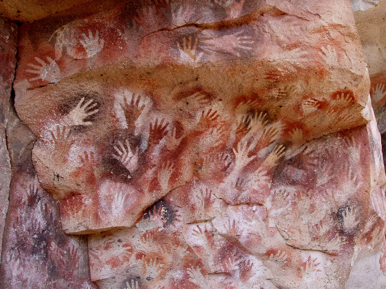
The Cueva de las Manos, Río Pinturas, contains an exceptional assemblage of cave art, executed between 13,000 and 9,500 years ago. It takes its name (Cave of the Hands) from the stencilled outlines of human hands in the cave, but there are also many depictions of animals, such as guanacos (Lama guanicoe ), still commonly found in the region, as well as hunting scenes. The people responsible for the paintings may have been the ancestors of the historic hunter-gatherer communities of Patagonia found by European settlers in the 19th century.
UNESCO Justification of the World Heritage Site
Criterion (iii): The Cueva de las Manos contains an outstanding collection of prehistoric rock art which bears witness to the culture of the earliest human societies in South America.
Encyclopedia Record: Cueva de las Manos
Cueva de las Manos is a cave and complex of rock art sites in the province of Santa Cruz, Argentina, 163 km (101 mi) south of the town of Perito Moreno. It is named for the hundreds of paintings of hands stenciled, in multiple collages, on the rock walls. The art was created in several waves between 7,300 BC and 700 AD, during the Archaic period of pre-Columbian South America. The age of the paintings was calculated from the remains of bone pipes used for spraying the paint on the wall of the cave to create the artwork, radiocarbon dating of the artwork, and stratigraphic dating.Additional Site Details
Area: 600 hectares
Number of Components: 1
Coordinates: -47.15 , -70.66666667