World Heritage Identification Number: 1430
World Heritage since: 2013
Category: Natural Heritage
WHE Type: Natural Landscapes & Geographic Features
Transboundary Heritage: No
Endangered Heritage: No
Country: 🇳🇦 Namibia
Continent: Africa
UNESCO World Region: Africa
Map
The Namib Sand Sea: A Unique Coastal Desert in Southern Africa
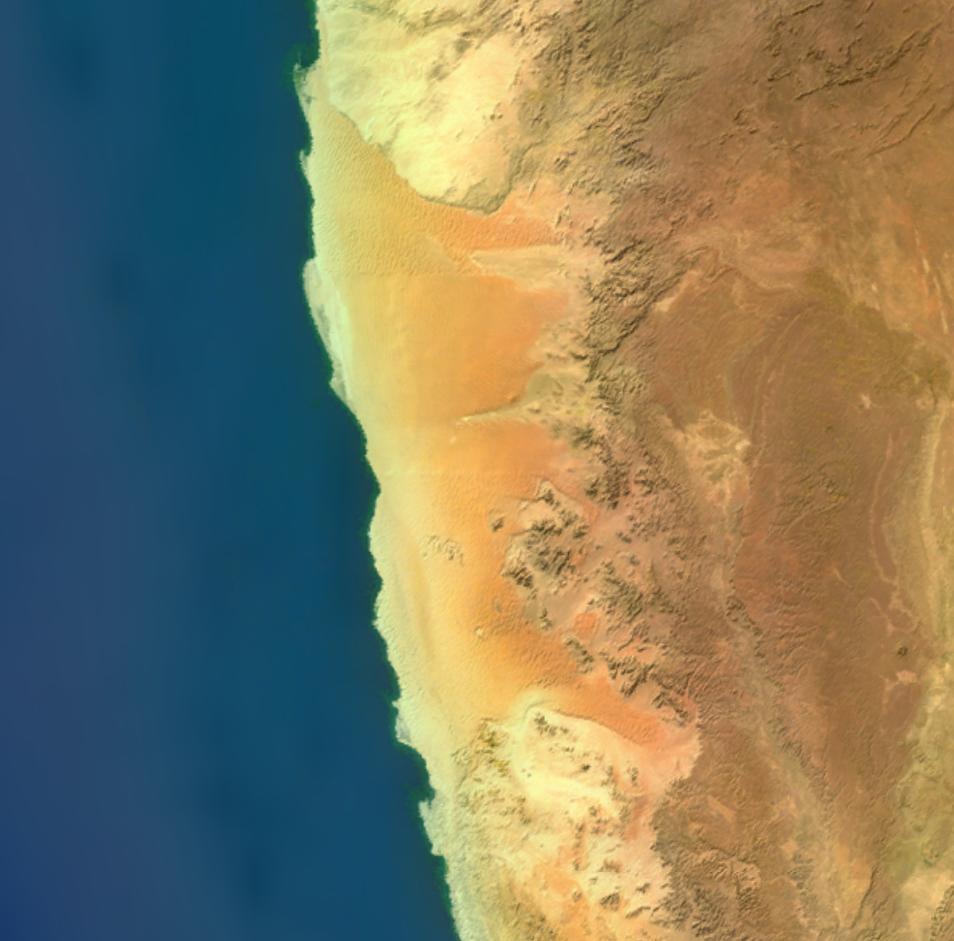
The Namib Sand Sea, located along the Atlantic coast of Namibia, is a remarkable example of a coastal desert and forms part of the wider Namib Desert, which extends into Angola and South Africa. Inscribed as a UNESCO World Heritage Site in 2013, the Namib Sand Sea is characterized by extensive fog-influenced dune fields covering an area of more than three million hectares.
The Namib Sand Sea consists of two distinct dune systems. The older, semi-consolidated system lies beneath the younger, active one. These dunes are formed by the transportation of materials thousands of kilometers from the interior, carried by rivers, ocean currents, and winds. The result is a landscape of exceptional beauty, featuring gravel plains, coastal flats, rocky hills, inselbergs within the sand sea, a coastal lagoon, and ephemeral rivers.
One of the most striking aspects of the Namib Sand Sea is its reliance on fog as its primary source of water. This unique environment supports a diverse array of endemic invertebrates, reptiles, and mammals that have adapted to an ever-changing variety of microhabitats and ecological niches. The desert is estimated to be 55–80 million years old, making it the oldest desert globally, surpassing South America's Atacama Desert in age, though the Atacama is often considered the driest.
Annual precipitation in the Namib Sand Sea varies significantly, ranging from just 2 millimeters in the aridest regions to 200 millimeters at the escarpment. Despite these challenging conditions, much of the Namib Sand Sea is protected within Namibia’s Namib-Naukluft National Park, and environmental protection is further reinforced by Namibia’s constitution, which emphasizes sustainable natural resource management.
Geographically, the Namib Sand Sea occupies the central portion of the Namib Desert, extending inland from the Atlantic coast toward the Great Escarpment, where elevation gradually increases. To the north, the Namib Desert continues into Angola’s Moçâmedes Desert, while to the east it transitions into semi-arid landscapes.
Overall, the Namib Sand Sea is a testament to the resilience of life in extreme environments. Its unique combination of geography, climate, and biodiversity make it a vital component of Southern Africa's natural heritage. As a UNESCO World Heritage Site, it serves as a reminder of the importance of preserving these unique ecosystems for future generations.
UNESCO Description of the World Heritage Site
Namib Sand Sea is the only coastal desert in the world that includes extensive dune fields influenced by fog. Covering an area of over three million hectares and a buffer zone of 899,500 hectares, the site is composed of two dune systems, an ancient semi-consolidated one overlain by a younger active one. The desert dunes are formed by the transportation of materials thousands of kilometres from the hinterland, that are carried by river, ocean current and wind. It features gravel plains, coastal flats, rocky hills, inselbergs within the sand sea, a coastal lagoon and ephemeral rivers, resulting in a landscape of exceptional beauty. Fog is the primary source of water in the site, accounting for a unique environment in which endemic invertebrates, reptiles and mammals adapt to an ever-changing variety of microhabitats and ecological niches.
UNESCO Justification of the World Heritage Site
Criterion (vii): The property is the world’s only coastal desert that includes extensive dune fields influenced by fog. This alone makes it exceptional at a global scale, but it also represents a superlative natural phenomenon on account of the three-part ‘conveyor system’ which has produced the massive dune field from material transported over thousands of kilometres from the interior of the African continent by river erosion, ocean currents and wind. Most dune fields elsewhere in the world are derived from bedrock eroded in situ. The age, extent and height of the dunes are outstanding and the property also exhibits a range of features that give it exceptional aesthetic qualities. The diversity of dune formations, their ever-changing form and the range of colour and texture create landscapes of outstanding natural beauty.
Criterion (viii): The property represents an exceptional example of ongoing geological processes involving the formation of the world’s only extensive dune system in a coastal fog desert through transport of material over thousands of kilometres by river, ocean current and wind. Although the nominated area encompasses only the Aeolian elements of this ongoing geological process the other elements of the ‘conveyor system’ are assured. The diversity of the ever-changing dune formations, sculpted by pronounced daily and seasonal changes in dominant wind directions is also exceptional at a global scale within such a relatively small area.
Criterion (ix): The property is an exceptional example of ongoing ecological process in a coastal fog desert where plant and animal communities are continuously adapting to life in a hyper arid environment. Fog serves as the primary source of water and this is harvested in extraordinary ways while the ever-mobile wind-blown dunes provide an unusual substrate in which well-oxygenated subsurface sand offers respite and escape for ‘swimming’ and ‘diving’ invertebrates, reptiles and mammals. The outstanding combination and characteristics of the physical environment – loose sand, variable winds and fog gradients across the property – creates an ever-changing variety of micro-habitats and ecological niches that is globally unique on such a scale.
Criterion (x): The property is of outstanding importance for the in-situ conservation of an unusual and exceptional array of endemic species uniquely adapted to life in a hyper-arid desert environment in which fog serves as the primary source of water. These are mostly invertebrate animals and display a range of very rare behavioural and physiological adaptations to the desert environment where they live that contributes significantly to the property’s OUV.
Encyclopedia Record: Namib
The Namib is a coastal desert in Southern Africa. According to the broadest definition, the Namib stretches for more than 2,000 kilometres (1,200 mi) along the Atlantic coasts of Angola, Namibia, and northwest South Africa, extending southward from the Carunjamba River in Angola, through Namibia and to the Olifants River in Western Cape, South Africa. The Namib's northernmost portion, which extends 450 kilometres (280 mi) from the Angola-Namibia border, is known as Moçâmedes Desert, while its southern portion approaches the neighboring Kalahari Desert. From the Atlantic coast eastward, the Namib gradually ascends in elevation, reaching up to 200 kilometres (120 mi) inland to the foot of the Great Escarpment. Annual precipitation ranges from 2 millimetres (0.079 in) in the aridest regions to 200 millimetres (7.9 in) at the escarpment, making the Namib the only true desert in southern Africa. Having endured arid or semi-arid conditions for roughly 55–80 million years, the Namib may be the oldest desert in the world and contains some of the world's driest regions, with only western South America's Atacama Desert to challenge it for age and aridity benchmarks. Most of Namibia's share of the Namib Desert is protected under the environmental protection included in the constitution of the country.Additional Site Details
Area: 3,077,700 hectares
Number of Components: 1
(viii) — Outstanding example representing major earth stages
(ix) — Outstanding example representing ecological and biological processes
(x) — Contains most important habitats for biodiversity
Coordinates: -24.8852777778 , 15.4077777778
IUCN World Heritage Outlook
The 2025 Conservation Outlook on Namib Sand Sea reports the following assessment:
Source: International Union for Conservation of Nature (IUCN) · View assessment