World Heritage Identification Number: 1221
World Heritage since: 2007
Category: Cultural Heritage
WHE Type: Infrastructure & Industry
Transboundary Heritage: No
Endangered Heritage: No
Country: 🇨🇦 Canada
Continent: Americas
UNESCO World Region: Europe and North America
Map
Navigating History: The Rideau Canal - A Unesco World Heritage Site
The Rideau Canal, a veritable testament to engineering prowess and historical significance, stretches across 202 kilometers, connecting the Ottawa River at Ottawa with the Cataraqui River and Lake Ontario at Kingston, Ontario, Canada. This architectural marvel, inscribed as a UNESCO World Heritage Site in 2007, stands as a remarkable remnant of the early 19th-century canal-building era.
More to come…UNESCO Description of the World Heritage Site
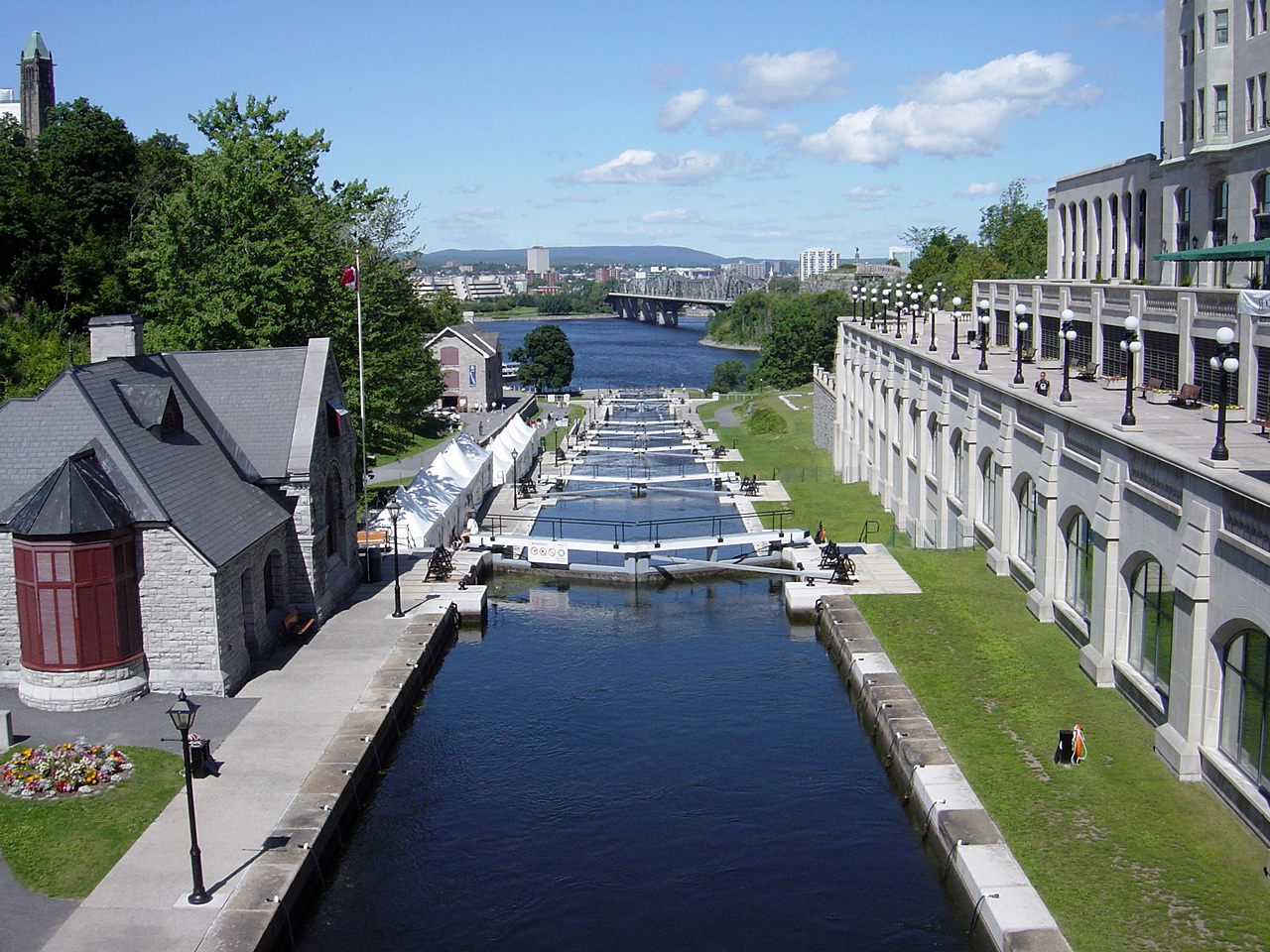
The Rideau Canal, a monumental early 19th-century construction covering 202 km of the Rideau and Cataraqui rivers from Ottawa south to Kingston Harbour on Lake Ontario, was built primarily for strategic military purposes at a time when Great Britain and the United States vied for control of the region. The site, one of the first canals to be designed specifically for steam-powered vessels, also features an ensemble of fortifications. It is the best-preserved example of a slackwater canal in North America, demonstrating the use of this European technology on a large scale. It is the only canal dating from the great North American canal-building era of the early 19th century to remain operational along its original line with most of its structures intact.
UNESCO Justification of the World Heritage Site
Criterion (i): The Rideau Canal remains the best preserved example of a slackwater canal in North America demonstrating the use of European slackwater technology in North America on a large scale. It is the only canal dating from the great North American canal-building era of the early 19th century that remains operational along its original line with most of its original structures intact.
Criterion (iv): The Rideau Canal is an extensive, well preserved and significant example of a canal which was used for a military purpose linked to a significant stage in human history - that of the fight to control the north of the American continent. The nominated property includes all the main elements of the original canal together with relevant later changes in the shape of watercourses, dams, bridges, fortifications, lock stations and related archaeological resources. The original plan of the canal, as well as the form of the channels, has remained intact. The Rideau Canal has fulfilled its original dynamic function as an operating waterway without interruption since its construction. Most of its lock gates and sluice valves are still operated by hand-powered winches. All the elements of the nominated area (canal, associated buildings and forts) are protected as national historic sites under the Historic Sites and Monuments Act 1952-3. A buffer zone has been established. Repairs and conservation of the locks, dams, canal walls and banks are carried out directly under the control of Parks Canada. Each year one third of the canal's assets are thoroughly inspected by engineers. A complete inventory thus exists of the state of conservation of all parts of the property. A Management Plan exists for the canal (completed in 1996 and updated in 2005), and plans are nearing completion for Fort Henry and the Kingston fortifications. The Canal Plan is underpinned by the Historic Canals Regulations which provide an enforcement mechanism for any activities that might impact on the cultural values of the monument.
Encyclopedia Record: Rideau Canal
The Rideau Canal is a 202-kilometre long canal that links the Ottawa River at Ottawa with the Cataraqui River and Lake Ontario at Kingston, Ontario, Canada. Its 46 locks raise boats from the Ottawa River 83 metres upstream along the Rideau River to the Rideau Lakes, and from there drop 50 metres downstream along the Cataraqui River to Kingston.Additional Site Details
Area: 21,454.81 hectares
Number of Components: 6
(iv) — Outstanding example of a type of building or landscape
Coordinates: 44.9943861111 , -75.765125
Image
© Bobak Ha'Eri, CC BY-SA 2.5 Resized from original. (This derivative is under the same CC BY-SA license.)
