World Heritage Identification Number: 1193
World Heritage since: 2005
Category: Natural Heritage
WHE Type: Protected Areas & National Parks
Transboundary Heritage: No
Endangered Heritage: No
Country: 🇯🇵 Japan
Continent: Asia
UNESCO World Region: Asia and the Pacific
Map
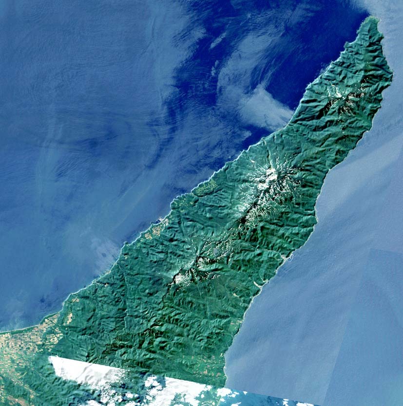
Shiretoko: A Unique Ecosystem at the Edge of the Earth
The Shiretoko Peninsula, situated in the northeastern corner of Hokkaido, Japan's largest island, stands as a testament to the intricate interplay between marine and terrestrial ecosystems. Inscribed as a UNESCO World Heritage Site in 2005, this remote and pristine region offers a unique glimpse into the rich biodiversity that thrives at the edge of the Earth.
More to come…UNESCO Description of the World Heritage Site
Shiretoko Peninsula is located in the north-east of Hokkaido, the northernmost island of Japan. The site includes the land from the central part of the peninsula to its tip (Shiretoko Cape) and the surrounding marine area. It provides an outstanding example of the interaction of marine and terrestrial ecosystems as well as extraordinary ecosystem productivity, largely influenced by the formation of seasonal sea ice at the lowest latitude in the northern hemisphere. It has particular importance for a number of marine and terrestrial species, some of them endangered and endemic, such as Blackiston’s fish owl and the Viola kitamiana plant. The site is globally important for threatened seabirds and migratory birds, a number of salmonid species, and for marine mammals including Steller’s sea lion and some cetacean species.
UNESCO Justification of the World Heritage Site
Criterion (ix): Shiretoko provides an outstanding example of the interaction of marine and terrestrial ecosystems as well as extraordinary ecosystem productivity, largely influenced by the formation of seasonal sea ice at the lowest latitude in the northern hemisphere, occurring earlier here than in other sea ice areas.Illustrating ecological processes, phytoplankton blooms develop on the nutrients supplied by the melting sea ice and from the deep ocean, entering the system through circulation of currents. The food webs starting from the phytoplankton blooms involve fish, birds and mammals, and form dynamic ecosystems over ocean, rivers and forests.
Criterion (x): Shiretoko has particular importance for a number of marine and terrestrial species. Combining northern species from the continent and southern species from Honshu, the property supports a range of animal species. These include a number of endangered and endemic species, such as the Blackiston’s Fish owl and the plant species Viola kitamiana. The property has one of the highest recorded densities of brown bear populations in the world. The property has significance as a habitat for globally threatened sea birds and is a globally important area for migratory birds. Shiretoko is also globally important for a number of salmonid species, encompassing habitat in many small watersheds and supporting several species of Pacific salmonids, including White spotted charr, masu salmon, chum salmon and pink salmon. Those watersheds have specific importance as it is the southernmost habitat in the world for the sea run of the Dolly varden. The property is a seasonal habitat for a number of marine mammals including the Steller’s sea lion, Spotted Seal, Killer Whale, Minke Whale, Sperm Whale, Dall’s Porpoise and the endangered Fin Whale.
Encyclopedia Record: Shiretoko Peninsula
The Shiretoko Peninsula is located on the easternmost portion of the Japanese island of Hokkaido, protruding into the Sea of Okhotsk. It is separated from Kunashiri Island by the Nemuro Strait. The name Shiretoko is derived from the Ainu word sir etok, meaning "the end of the Earth" or "the place where the Earth protrudes". The towns of Rausu and Shari are found on the peninsula.Additional Site Details
Area: 71,100 hectares
Number of Components: 1
(x) — Contains most important habitats for biodiversity
Coordinates: 43.94944 , 144.96583
IUCN World Heritage Outlook
The 2025 Conservation Outlook on Shiretoko reports the following assessment:
Source: International Union for Conservation of Nature (IUCN) · View assessment
Image
っ, Public domain
