World Heritage Identification Number: 387
World Heritage since: 1986
Category: Mixed Cultural Heritage and Natural Heritage
WHE Type: Natural Landscapes & Geographic Features
Transboundary Heritage: No
Endangered Heritage: No
Country: 🇬🇧 United Kingdom of Great Britain and Northern Ireland
Continent: Europe
UNESCO World Region: Europe and North America
Map
St Kilda: A Remote Archipelago of Unparalleled Natural Beauty and Historical Significance
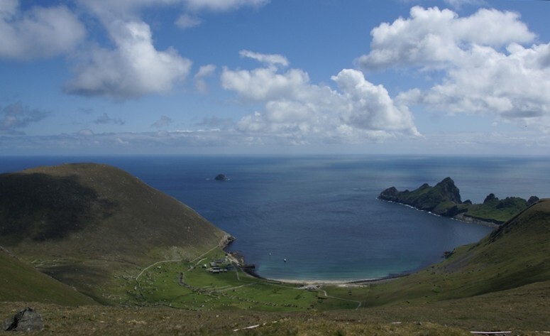
St Kilda, located 35 nautical miles west-northwest of North Uist in the North Atlantic Ocean, constitutes a unique and captivating chapter in the annals of Scottish history and natural heritage. This remote archipelago, administratively a part of the Comhairle nan Eilean Siar local authority area, consists of four main islands—Hirta, Dun, Soay, and Boreray—each offering a distinct blend of breathtaking landscapes, rich biodiversity, and historical remnants that bear testament to over two millennia of human habitation under challenging environmental conditions.
More to come…UNESCO Description of the World Heritage Site
This volcanic archipelago, with its spectacular landscapes, is situated off the coast of the Hebrides and comprises the islands of Hirta, Dun, Soay and Boreray. It has some of the highest cliffs in Europe, which have large colonies of rare and endangered species of birds, especially puffins and gannets. The archipelago, uninhabited since 1930, bears the evidence of more than 2,000 years of human occupation in the extreme conditions prevalent in the Hebrides. Human vestiges include built structures and field systems, the cleits and the traditional Highland stone houses. They feature the vulnerable remains of a subsistence economy based on the products of birds, agriculture and sheep farming.
UNESCO Justification of the World Heritage Site
Criterion (iii): St Kilda bears exceptional testimony to over two millennia of human occupation in extreme conditions.
Criterion (v): The cultural landscape of St Kilda is an outstanding example of land use resulting from a type of subsistence economy based on the products of birds, cultivating land and keeping sheep. The cultural landscape reflects age-old traditions and land uses, which have become vulnerable to change particularly after the departure of the islanders.
Criterion (vii): The scenery of the St Kilda archipelago is particularly superlative and has resulted from its volcanic origin followed by weathering and glaciation to produce a dramatic island landscape. The precipitous cliffs and sea stacks as well as its underwater scenery are concentrated in a compact group that is singularly unique.
Criterion (ix): St Kilda is unique in the very high bird densities that occur in a relatively small area, which is conditioned by the complex and different ecological niches existing in the site. There is also a complex ecological dynamic in the three marine zones present in the site that is essential to the maintenance of both marine and terrestrial biodiversity.
Criterion (x): St Kilda is one of the major sites in the North Atlantic and Europe for seabirds with over 1,000,000 birds using the island. It is particularly important for gannets, puffins and fulmars. The maritime grassland turf and underwater habitats are also significant and an integral element of the total island setting. The feral Soay sheep are also an interesting rare breed of potential genetic resource significance.
Encyclopedia Record: St Kilda, Scotland
St Kilda is a remote archipelago situated 35 nautical miles west-northwest of North Uist in the North Atlantic Ocean. It contains the westernmost islands of the Outer Hebrides of Scotland. The largest island is Hirta, whose sea cliffs are the highest in the United Kingdom; three other islands were also used for grazing and seabird hunting. The islands are administratively a part of the Comhairle nan Eilean Siar local authority area.Additional Site Details
Area: 24,201.4 hectares
Number of Components: 1
(v) — Outstanding example of traditional human settlement
(vii) — Contains superlative natural phenomena or beauty
(ix) — Outstanding example representing ecological and biological processes
(x) — Contains most important habitats for biodiversity
Coordinates: 57.81722222 , -8.576666667
IUCN World Heritage Outlook
The 2025 Conservation Outlook on St Kilda reports the following assessment:
Source: International Union for Conservation of Nature (IUCN) · View assessment
Image
© Otter, CC BY-SA 3.0 Resized from original. (This derivative is under the same CC BY-SA license.)
