World Heritage Identification Number: 1550
World Heritage since: 2017
Category: Cultural Heritage
WHE Type: Historic Cities & Urban Areas
Transboundary Heritage: No
Endangered Heritage: No
Country: 🇪🇷 Eritrea
Continent: Africa
UNESCO World Region: Africa
Map
Asmara: A Testament to Early Modernist Urbanism in Africa
Asmara, the capital city of Eritrea, stands as a unique testament to early modernist urbanism in Africa. Situated at an elevation of 2,325 meters above sea level, Asmara is not only the sixth highest capital globally but also boasts a rich architectural heritage that earned it the prestigious designation of a UNESCO World Heritage Site in 2017.
More to come…UNESCO Description of the World Heritage Site
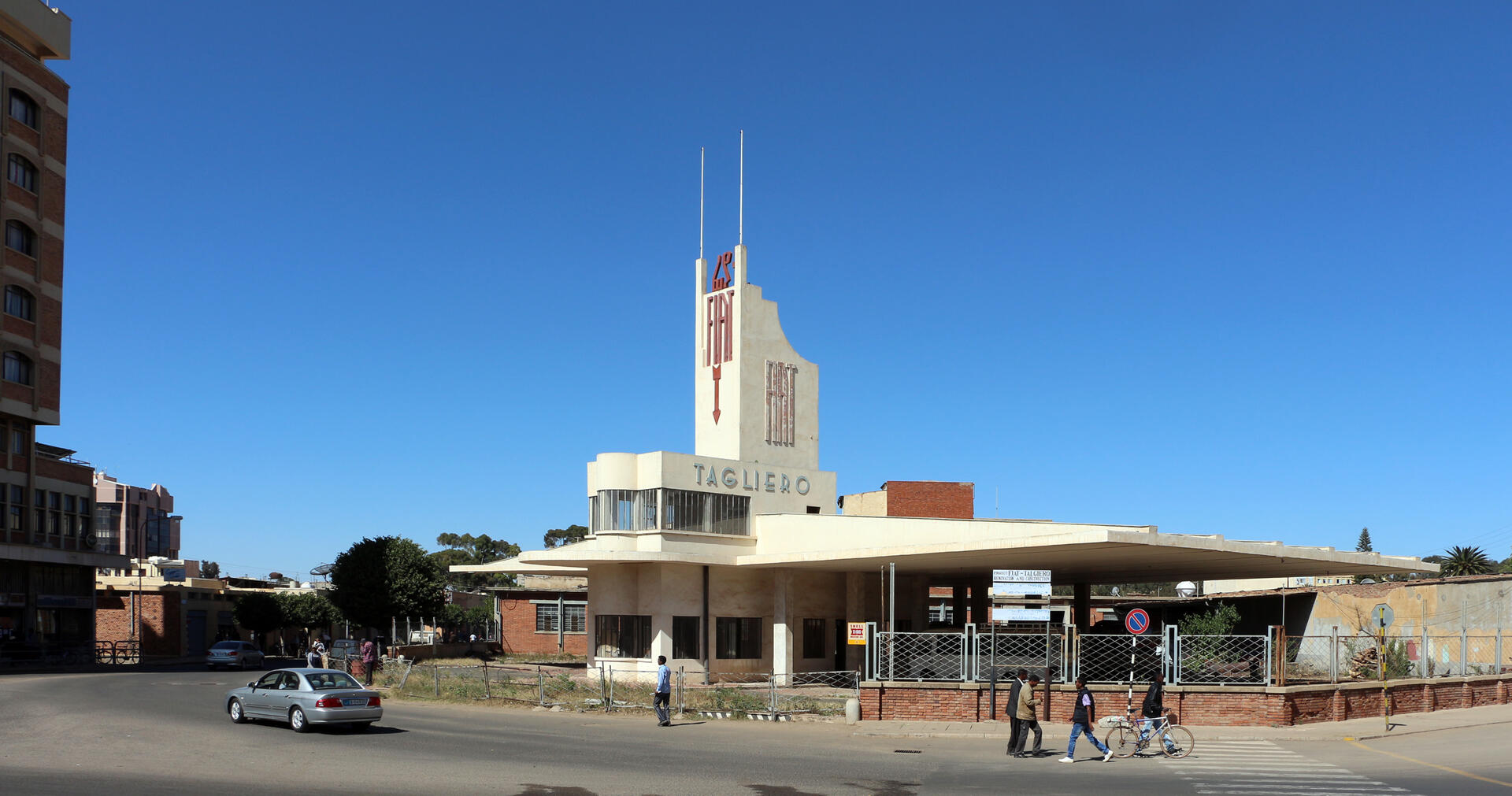
Located at over 2,000 m above sea level, the capital of Eritrea developed from the 1890s onwards as a military outpost for the Italian colonial power. After 1935, Asmara underwent a large scale programme of construction applying the Italian rationalist idiom of the time to governmental edifices, residential and commercial buildings, churches, mosques, synagogues, cinemas, hotels, etc. The property encompasses the area of the city that resulted from various phases of planning between 1893 and 1941, as well as the indigenous unplanned neighbourhoods of Arbate Asmera and Abbashawel. It is an exceptional example of early modernist urbanism at the beginning of the 20th century and its application in an African context.
UNESCO Justification of the World Heritage Site
Criterion (ii): Asmara: A Modernist African City, represents an outstanding example of the transposition and materialization of ideas about planning in an African context and were used for functional and segregation purposes. The adaptation to the local context is reflected in the urban layout and functional zoning, and in the architectural forms, which, although expressing a modernist and rationalist idiom, and exploiting modern materials and techniques, also relied on and borrowed heavily from local morphologies, construction methods, materials, skills and labour. Asmara’s creation and development contributed significantly to Eritrea’s particular response to the tangible legacies of its colonial past. Despite the evidence of its colonial imprint, Asmara has been incorporated into the Eritrean identity, acquiring important meaning during the struggle for self-determination that motivated early efforts for its protection.
Criterion (iv): Asmara’s urban layout and character, in combining the orthogonal grid with radial street patterns, and picturesque elements integrating topographical features, taking into account local cultural conditions created by different ethnic and religious groups, and using the principle of zoning for achieving racial segregation and functional organisation, bears exceptional witness to the development of the new discipline of urban planning at the beginning of the 20th century and its application in an African context, to serve the Italian colonial agenda. This hybrid plan, that combined the functional approach of the grid with the picturesque and the creation of scenic spaces, vistas, civic plaza and monumental places, served the functional, civic and symbolic requirements for a colonial capital. The architecture of Asmara complements the plan and forms a coherent whole, although reflecting eclecticism and Rationalist idioms, and is one of the most complete and intact collections of modernist/rationalist architecture in the world.
Encyclopedia Record: Asmara
Asmara, or Asmera, is the capital and most populous city of Eritrea, in the country's Central Region. It sits at an elevation of 2,325 metres (7,628 ft), making it the sixth highest capital in the world by altitude and the second highest capital in Africa. The city is located at the tip of an escarpment that is both the northwestern edge of the Eritrean Highlands and the Great Rift Valley in neighbouring Ethiopia. In 2017, the city was declared as a UNESCO World Heritage Site for its well-preserved Italian colonial modernist architecture. According to local traditions, the city was founded after four separate villages unified to live together peacefully after long periods of conflict. Asmara existed as a major settlement for over half a millennium and enjoyed some importance as it stood on the trade route to Massawa. Asmara first rose to prominence during the 20th century, when it became capital of Italian Eritrea. Under Italian rule the city of Asmara experienced rapid urbanization and modernization, to the point that was called Piccola Roma.Additional Site Details
Area: 481 hectares
Number of Components: 1
(iv) — Outstanding example of a type of building or landscape
Coordinates: 15.3352777778 , 38.9358333333
Image
© sailko, CC BY-SA 3.0 Resized from original. (This derivative is under the same CC BY-SA license.)
World Heritage Research
Discover scientific research and academic studies that deepen our understanding of Asmara: A Modernist African City from its history and significance to its conservation, management, and contemporary challenges.
-
Transmodern heritage as a space for imagining pluriversal relations : insights from the African 'periphery'
A groundbreaking study challenges the conventional binary narrative of colonial urban development, proposing that African encounters with modernity should be understood through the decolonial pluriversal perspective and the concept of transmodernity. Focusing on N'zima village in Grand-Bassam (Côte d'Ivoire) and Abbashawel area in Asmara (Eritrea), both inscribed as part of UNESCO World Heritage Sites, the research reveals these areas as spaces that contest Western onto-epistemologies. By rejecting the center-periphery dynamic inherent in colonial narratives, the study highlights how these African urban entities enable a pluralistic politics, offering a nuanced visualization of reality beyond the binaries created by Western modernity.
Human Sciences Research Council. (2026). Transmodern heritage as a space for imagining pluriversal relations : insights from the African 'periphery'. HSRC. https://doi.org/10.14749/32362368
View Publication Record | Read Publication -
Mobilizing the Racialized Built Environment in Asmara
The preservation of Asmara, an Italian colonial city in Eritrea, as a UNESCO World Heritage Site reflects a complex intersection of interests that prioritize architectural heritage over democratic and humanitarian concerns. This study reveals how narratives surrounding the 'white city' of Asmara—rooted in Italian modernist architecture—have been mobilized to bolster national identity under the authoritarian Afwerki regime while overlooking severe power asymmetries and current conditions. The research identifies three narrative strategies used by preservationists, which converge with those of international bodies (ICOMOS, World Heritage Committee), European Union states, and the local regime, each with distinct agendas: expanding modernist historiography, increasing African sites on the UNESCO List, gaining political leverage, and consolidating spatial control. The analysis critiques this convergence, highlighting a disconnect where architectural preservation is celebrated without addressing systemic issues, thereby reinforcing institutional positions while ignoring humanitarian realities.
Flahive, R. (2025). Mobilizing the Racialized Built Environment in Asmara. White Supremacy, Settler Colonialism, Modernist Architecture, and Contemporary Preservation, 127–141. https://doi.org/10.4324/9781003566588-6
View Publication Record | Read Publication -
Transmodern heritage as a space for imagining pluriversal relations—Insights from the African “periphery”
This study challenges the conventional binary narrative of colonial urban development by proposing transmodernity as a framework to understand the coexistence and interaction between European-planned cities (Grand-Bassam, Côte d'Ivoire) and African communities (N'zima village, Abbashawel in Asmara). It argues that these areas, inscribed on the UNESCO World Heritage List, represent not opposing sides but interconnected, pluralistic urban entities that resist Western modernity's center-periphery dynamics. The research employs a decolonial pluriversal perspective to reinterpret heritage, emphasizing the agency and ontological diversity of colonized African populations. By focusing on Abbashawel and N'zima, it highlights their role in visualizing alternative realities that contest binary classifications, offering a new lens for pluralistic politics.
Bialostocka, O. (2024). Transmodern heritage as a space for imagining pluriversal relations—Insights from the African “periphery”. Curator: The Museum Journal, 67(1), 269–282. Portico. https://doi.org/10.1111/cura.12595
View Publication Record | Read Publication -
Where Would I Walk to Decolonize Myself?
Asmara, Eritrea's capital, was inscribed as a UNESCO World Heritage Site in 2017, recognizing its unique colonial architecture but also highlighting the painful history of violence and racism. Recent documentaries and contemporary artworks by the Eritrean diaspora challenge Italy's unproblematized (post)colonial discourse, offering tools for decolonization. This study traces a 'filmic path' that serves as a collective memory preservation tool, countering amnesia and providing a framework to rethink Italian 'difficult heritage.' The research approach involves analyzing contemporary media productions, aiming to bridge the gap between colonial narratives and diasporic experiences while offering insights for heritage studies.
Cappelletto, N. (2024). Where Would I Walk to Decolonize Myself? Future Stories in the Global Heritage Industry, 50–69. https://doi.org/10.4324/9781003496861-3
View Publication Record | Read Publication -
Asmara’s cultural integration: bridging the past and the future
Asmara, a UNESCO-listed modernist city in Eritrea, exemplifies how colonial urban heritage can be reappropriated to foster social, economic, and cultural development. The study highlights the successful integration of Italian modernist architecture with local vernacular techniques, such as the 'monkey head' masonry method, which combines rough stonework with wooden beams—a practice rooted in Eritrean tradition. This fusion not only preserves architectural identity but also enriches it with inclusive values, offering a model for heritage conservation. The research emphasizes the need for intergenerational dialogue and community engagement to sustain this process, particularly through participatory workshops that bridge traditional and modern constructive cultures. By doing so, Asmara demonstrates how intangible cultural heritage can be leveraged for sustainable urban regeneration.
De santis, E., & Ciufo, F. (2024). Asmara’s cultural integration: bridging the past and the future. Proceedings Africa24 Conference. https://doi.org/10.4995/africa24.2024.18903
View Publication Record | Read Publication -
Un patrimonio celato fra le architetture moderne di Asmara: avanguardie e sperimentazioni costruttive italiane in terra d’Oltremare
Asmara, the first African city inscribed on UNESCO's World Heritage list since 2017, stands out for its preservation of Italian Rationalist architecture, a key example of Modernism with local stylistic adaptations. Despite decades of political instability and challenging maintenance conditions, these structures retain their originality, showcasing technological and constructive innovations that reflect the experimental spirit of their time. The study employs a 'deconstruction' approach to classify this heritage, aiming to safeguard both its material and immaterial values. This method allows for a comprehensive analysis of the architectural patents and construction solutions, which have been under-researched but are crucial to understanding Asmara's unique urban landscape.
Carbonara, G., & Trausi, P. P. (2023). Un patrimonio celato fra le architetture moderne di Asmara: avanguardie e sperimentazioni costruttive italiane in terra d’Oltremare. Restauro Archeologico, 30(1). https://doi.org/10.36253/rar-14300
View Publication Record | Read Publication -
Prologue: Locating the Modern
This issue of Curator challenges the Eurocentric master narrative of modernism, advocating for a more inclusive and diverse understanding of modernity that acknowledges global contributions. It highlights the colonial matrix of power that has historically marginalized non-Western perspectives in heritage studies. Through case studies from across Africa, the research deconstructs the linear progression of Western modernity, proposing alternative epistemologies such as 'transmodernity' and 'border thinking.' The study also explores how African modernist architecture often drew on precolonial aesthetics, creating unique forms that question colonial power structures. Additionally, it addresses the precarity of modern heritage in Africa, emphasizing the need for sustainable preservation and community engagement to ensure equitable futures.
Vawda, S., & Denison, E. (2022). Prologue: Locating the Modern. Curator: The Museum Journal, 65(3), 479–484. Portico. https://doi.org/10.1111/cura.12518
View Publication Record | Read Publication