World Heritage Identification Number: 1452
World Heritage since: 2014
Category: Cultural Heritage
WHE Type: Buildings & Architectural Ensembles
Transboundary Heritage: No
Endangered Heritage: No
Country: 🇹🇷 Türkiye
Continent: Asia
UNESCO World Region: Europe and North America
Map
Bursa and Cumalıkızık: A Historical Journey into the Birthplace of the Ottoman Empire
The City of Bursa and the nearby village of Cumalıkızık, located in the southwestern Marmara region of Turkey, form a significant historical site known as "Bursa and Cumalıkızık: the Birth of the Ottoman Empire." Inscribed as a UNESCO World Heritage Site in 2014, this serial nomination offers a unique insight into the establishment of the Ottoman Empire in the early 14th century.
More to come…UNESCO Description of the World Heritage Site
This property is a serial nomination of eight component sites in the City of Bursa and the nearby village of Cumalıkızık, in the southern Marmara region. The site illustrates the creation of an urban and rural system establishing the Ottoman Empire in the early 14th century. The property embodies the key functions of the social and economic organization of the new capital which evolved around a civic centre. These include commercial districts of khans, kulliyes (religious institutions) integrating mosques, religious schools, public baths and a kitchen for the poor, as well as the tomb of Orhan Ghazi, founder of the Ottoman dynasty. One component outside the historic centre of Bursa is the village of Cumalıkızık, the only rural village of this system to show the provision of hinterland support for the capital.
UNESCO Justification of the World Heritage Site
Criterion (i): Bursa was created and managed by the first Ottoman sultans, through an innovative and ingenious system, which developed an unprecedented urban planning process. Using the semi-religious Ahi brotherhood organizations to run commercial life, and making the best use of the public endowment system Waqf (relating kulliyes and villages), they established kulliyes as nuclei providing all public infrastructure services prior to the creation of neighbourhoods. These centres allowed for the fast establishment of a vivid, sustainable new capital for one of the most rapidly expanding empires of the world.
Criterion (ii): Bursa, as the first capital of the Ottoman Empire, was of key importance as a reference for the development of later Ottoman cities. The new urban development approach introduced by the early Ottoman Sultans was based on the construction of public infrastructure complexes outside the existing city core surrounded by walls, and created a new town for non-urban population, which became the model Ottoman city, later referenced throughout the expansion of the Ottoman Empire. The new capital, with its social, religious and commercial functions reflects the values of the society and the values it accepted from its neighbours, during long years of migration from central Asia to the West. This is also reflected in the integration of Byzantine, Seljuk, Arab, Persian and other influences in architectural stylistics.
Criterion (iv): Bursa and Cumalıkızık illustrate the first capital of the Ottoman Sultans, rulers of an Empire reaching from Anatolia to Yemen and including parts of Europe and North Africa for hundreds of years, which developed a unique architectural plan called “Bursa style” or “inverted T plan”. In the first stage, the inverted T planned mosques, with guest rooms, were able to meet the functions of independent buildings such as public kitchen and madrasah, which were constructed in the complexes as separate buildings, in later stages. Kulliyes, as social units, meeting the requirements of the society and facilitating life, shaped the city by taking the multifunctional structure of this plan type as an example. In other words, the multifunctional inverted T plan is an exceptional building type which illustrates uniquely the city planning system in Bursa. These kulliyes, with their individual buildings constitute the urban nuclei of this system and characteristically shape the urban landscape of Bursa. While individual architectural components in Bursa can be considered as outstanding examples of architectural type, this criterion is met through the ensembles, created by these components (khans, bedesten, mosques, madrasahs, tombs, hamams, and houses).
Criterion (vi): Bursa is directly associated with important historical events, myths, ideas and traditions from the early Ottoman period. The mystic image of the city, created through the presence of the tombs of early Ottoman sultans and the famous Hacivat and Karagöz characters who were workers in the construction of the Orhan Ghazi Kulliye, retains close associations to early Ottoman life. Many sultans and courtiers, then the leaders of the Muslim World, recognized the importance of Bursa as the spiritual capital of the Ottoman Empire, even after the conquest of İstanbul and demonstrated their loyalty to their ancestors and the city, by choosing Bursa as the location for burial.
Encyclopedia Record: Bursa
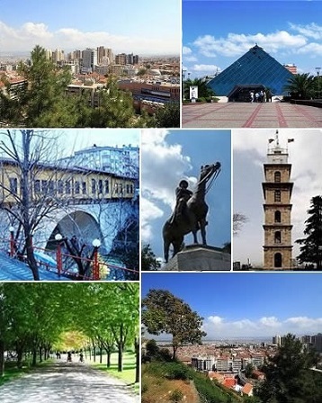
Bursa is a city in northwestern Turkey and the administrative center of Bursa Province. It is the fourth-most populous city in Turkey and second-most populous in the Marmara Region after Istanbul. According to 2025 end of year estimate, the province has a population of 3,263,011 while Bursa city has a population of around 2.5 million. Bursa is one of the centers of Turkey's automotive production, becoming an industrial center of the country. The city provides various places of interest.Additional Site Details
Area: 27.467 hectares
Number of Components: 8
(ii) — Significant interchange of human values
(iv) — Outstanding example of a type of building or landscape
(vi) — Directly associated with events or living traditions
Coordinates: 40.1847305556 , 29.0623361111
Image
© see above, CC BY-SA 3.0 Resized from original. (This derivative is under the same CC BY-SA license.)
