World Heritage Identification Number: 1434
World Heritage since: 2018
Category: Natural Heritage
WHE Type: Natural Landscapes & Geographic Features
Transboundary Heritage: No
Endangered Heritage: No
Country: 🇫🇷 France
Continent: Europe
UNESCO World Region: Europe and North America
Map
The Chaîne des Puys - Limagne Fault Tectonic Arena: An Emblematic Segment of the West European Rift
The Chaîne des Puys - Limagne fault tectonic arena, inscribed as a UNESCO World Heritage Site in 2018, offers a unique insight into the geological processes that have shaped our planet over millions of years. This remarkable region, situated in the heart of France, provides an exceptional illustration of continental break-up, or rifting, one of the five major stages of plate tectonics.
More to come…UNESCO Description of the World Heritage Site
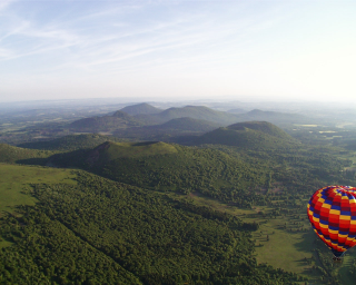
Situated in the centre of France, the property comprises the long Limagne fault, the alignments of the Chaîne des Puys volcanoes and the inverted relief of the Montagne de la Serre. It is an emblematic segment of the West European Rift, created in the aftermath of the formation of the Alps, 35 million years ago. The geological features of the property demonstrate how the continental crust cracks, then collapses, allowing deep magma to rise and cause uplifting at the surface. The property is an exceptional illustration of continental break-up – or rifting – which is one of the five major stages of plate tectonics.
UNESCO Justification of the World Heritage Site
Criterion (viii): Continental drift, manifested through plate tectonics, is an essential paradigm for the history of the Earth as it explains the current make-up of oceans and continents and their past and future movements. The property is an exceptional illustration of the phenomenon of continental break-up, or rifting, which is one of the five major stages of plate tectonics. The Chaîne des Puys - Limagne fault tectonic arena presents a coincident view of all the representative processes of continental break-up and reveals their intrinsic links. The geological formations of the property, and their specific layout, illustrate with clarity this planet-wide process and its effects on a large and small scale on the landscape. This concentration has a demonstrated global significance in terms of its completeness, density and expression and has contributed to the site’s prominence since the 18th century for the study of classical geological processes.
Encyclopedia Record: Chaîne des Puys
The Chaîne des Puys is a north-south oriented chain of cinder cones, lava domes, and maars in the Massif Central of France. The chain is about 40 km (25 mi) long, and the identified volcanic features, which constitute a volcanic field, include 48 cinder cones, eight lava domes, and 15 maars and explosion craters. Its highest point is the lava dome of Puy de Dôme, located near the middle of the chain, which is 1,465 m (4,806 ft) high. The name of the range comes from a French term, puy, which refers to a volcanic mountain with a rounded profile. A date of 4040 BC is usually given for the last eruption of a Chaîne des Puys volcano.Additional Site Details
Area: 24,223 hectares
Number of Components: 1
Coordinates: 45.7793888889 , 2.9651111111
IUCN World Heritage Outlook
The 2025 Conservation Outlook on Chaîne des Puys - Limagne fault tectonic arena reports the following assessment:
Source: International Union for Conservation of Nature (IUCN) · View assessment
Image
© F. THURION Original uploader was Accrochoc at fr.wikipedia, CC BY-SA 3.0 Resized from original. (This derivative is under the same CC BY-SA license.)
