World Heritage Identification Number: 1551
World Heritage since: 2017
Category: Cultural Heritage
WHE Type: Historic Cities & Urban Areas
Transboundary Heritage: No
Endangered Heritage: No
Country: 🇮🇳 India
Continent: Asia
UNESCO World Region: Asia and the Pacific
Map
The Historic City of Ahmadabad: A Unique Blend of Architecture and Culture
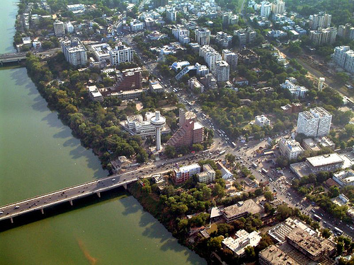
The Historic City of Ahmadabad, located on the eastern bank of the Sabarmati River in the Indian state of Gujarat, stands as a testament to the rich cultural and architectural history of India. Inscribed as a UNESCO World Heritage Site in 2017, this ancient city offers a unique blend of Islamic, Hindu, and Jain architecture that reflects the diverse cultural influences over six centuries.
More to come…UNESCO Description of the World Heritage Site
The walled city of Ahmadabad, founded by Sultan Ahmad Shah in the 15th century, on the eastern bank of the Sabarmati river, presents a rich architectural heritage from the sultanate period, notably the Bhadra citadel, the walls and gates of the Fort city and numerous mosques and tombs as well as important Hindu and Jain temples of later periods. The urban fabric is made up of densely-packed traditional houses (pols) in gated traditional streets (puras) with characteristic features such as bird feeders, public wells and religious institutions. The city continued to flourish as the capital of the State of Gujarat for six centuries, up to the present.
UNESCO Justification of the World Heritage Site
Criterion (ii): The historic architecture of the city of the 15th century Sultanate period exhibited an important interchange of human values over its span of time which truly reflected the culture of the ruling migrant communities. The settlement planning was based on the respective tenets of human values and mutually accepted norms of community living and sharing. Its monumental buildings representative of the religious philosophy exemplified the best of the crafts and technology which saw growth of an important regional Sultanate architectural expression that is unparalleled in India. In order to establish their dominance in the region, the Sultanate rulers recycled the parts and elements of local religious buildings to reassemble those into building of mosques in the city. Many new mosques were also built in the manner of smaller edifices with maximum use of local craftsmen and masons, allowing them the full freedom to employ their indigenous craftsmanship. Therefore, the resultant architecture developed a unique provincial Sultanate idiom unknown in other parts of the subcontinent where local traditions and crafts were accepted in religious buildings of Islam, even if they did not strictly follow the tenets for Islamic religious buildings. The monuments of Sultanate period thus provide a unique phase of development of architecture and technology for monumental arts during the 15th century period of history of western India.
Criterion (v): Ahmadabad city’s settlement planning in a hierarchy of living environment, with streets as also community spaces, is representative of the local wisdom and sense of strong community bondage. The house is a self-sufficient unit with its own provisions for water, sanitation and climatic control (the court yard as the focus). Its image and its conception with religious symbolism expressed through wood carving and canonical bearings is an ingenious example of habitat. This, when adopted by the community as an acceptable agreeable form, generated an entire settlement pattern with community needs expressed in its public spaces at the settlement level and composed the self-sufficient gated street “pol”. Thus Ahmadabad’s settlement patterns of neighbouring close-packed pol provide an outstanding example of human habitation.
Encyclopedia Record: Ahmedabad
Ahmedabad, also spelled Amdavad, is the most populous city in the Indian state of Gujarat. It is the administrative headquarters of the Ahmedabad district and the seat of the Gujarat High Court. Ahmedabad's population of 5,570,585 makes it the fifth-most populous city in India, and the encompassing urban agglomeration population was estimated at 8,854,444 is the seventh-most populous in India. Ahmedabad is located near the banks of the Sabarmati River, 25 km (16 mi) from the capital of Gujarat, Gandhinagar, also known as its twin city.Additional Site Details
Area: 535.7 hectares
Number of Components: 1
(v) — Outstanding example of traditional human settlement
Coordinates: 23.0263888889 , 72.5880555556