World Heritage Identification Number: 482
World Heritage since: 1988
Category: Cultural Heritage
WHE Type: Historic Cities & Urban Areas
Transboundary Heritage: No
Endangered Heritage: No
Country: 🇲🇽 Mexico
Continent: Americas
UNESCO World Region: Latin America and the Caribbean
Map
Exploring the Rich History and Architectural Wonders of the Historic Town of Guanajuato and Adjacent Mines
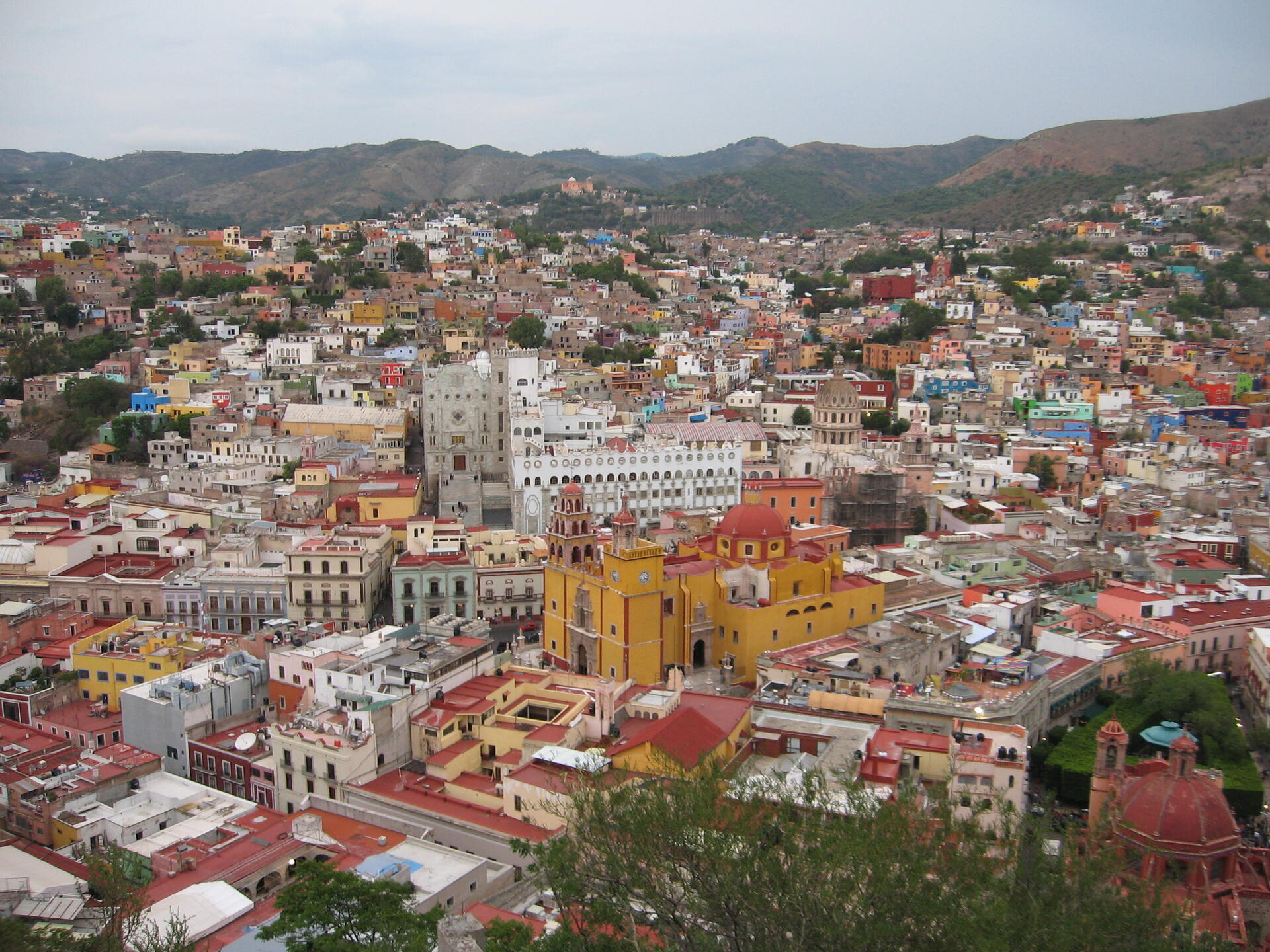
The Historic Town of Guanajuato and Adjacent Mines, a UNESCO World Heritage Site since 1988, offers visitors a unique blend of history, culture, and natural beauty. Situated in central Mexico, this charming city serves as the capital of the State of Guanajuato and is nestled within a narrow valley, giving it a distinctive layout with narrow, winding streets and alleys. Some of these passageways are so tight that they cannot accommodate vehicles, while others consist of long staircases ascending the surrounding hillsides. A significant portion of the city's thoroughfares is either partially or entirely underground, adding to the town's intriguing character.
More to come…UNESCO Description of the World Heritage Site
Founded by the Spanish in the early 16th century, Guanajuato became the world's leading silver-extraction centre in the 18th century. This past can be seen in its 'subterranean streets' and the 'Boca del Inferno', a mineshaft that plunges a breathtaking 600 m. The town's fine Baroque and neoclassical buildings, resulting from the prosperity of the mines, have influenced buildings throughout central Mexico. The churches of La Compañía and La Valenciana are considered to be among the most beautiful examples of Baroque architecture in Central and South America. Guanajuato was also witness to events which changed the history of the country.
UNESCO Justification of the World Heritage Site
Criterion (i): Guanajuato possesses several of the most beautiful examples of Baroque architecture in the New World. The churches of La Compañía (1745-1765) and above all La Valenciana (1765-1788) are masterpieces of the Mexican Churrigueresque style. In the field of the history of technology, Guanajuato may also pride itself on unique artistic achievements such as the ‘Boca del Infierno”’, a 12 metres in diameter that plunges a breathtaking 600 metres.
Criterion (ii): The influence of Guanajuato was felt in the majority of the mining towns of northern Mexico from the 16th to the 18th centuries. Though more modest due to the tardy appearance of the process of industrialisation, Guanajuato’s place in world technological history is nonetheless far from negligible.
Criterion (iv): Guanajuato is an outstanding example of an architectural ensemble that incorporates the industrial and economic aspects of a mining operation. Just as the major 18th century hydraulic works are inextricably linked to an urban topography determined by the confines of the river path and mineral outcrops, so the Baroque buildings are directly linked to the wealth of the mines. The church of La Valenciana and the Casa Rul y Valenciana were financed by the most prosperous mines. The more modest operations of Cata and Mellado also boasted churches, palaces or houses located near the mines or in the town.
Criterion (vi) : Historic Town of Guanajuato and Adjacent Mines is directly and tangibly associated with world economic history, particularly that of the 18th century.
Encyclopedia Record: Guanajuato (city)
Guanajuato is a municipality in central Mexico and the capital of the State of Guanajuato. It is part of the macroregion of the Bajío. It is located in a narrow valley, which makes its streets narrow and winding. Most are alleys that cars cannot pass through, and some are long sets of stairs up the mountainsides. Many of the city's thoroughfares are partially or fully underground. The historic center has numerous small plazas and colonial-era mansions, churches, and civil constructions built using pink or green sandstone. The city historic center and the adjacent mines were proclaimed a World Heritage Site by UNESCO in 1988.Additional Site Details
Area: 2,167.5 hectares
Number of Components: 1
(ii) — Significant interchange of human values
(iv) — Outstanding example of a type of building or landscape
(vi) — Directly associated with events or living traditions
Coordinates: 21.01694 , -101.25556
Image
© Anders Lagerås, CC BY-SA 3.0 Resized from original. (This derivative is under the same CC BY-SA license.)
