World Heritage Identification Number: 1360
World Heritage since: 2012
Category: Cultural Heritage
WHE Type: Infrastructure & Industry
Transboundary Heritage: No
Endangered Heritage: No
Country: 🇫🇷 France
Continent: Europe
UNESCO World Region: Europe and North America
Map
The Nord-Pas de Calais Mining Basin: A Testimony to Industrial Europe's History
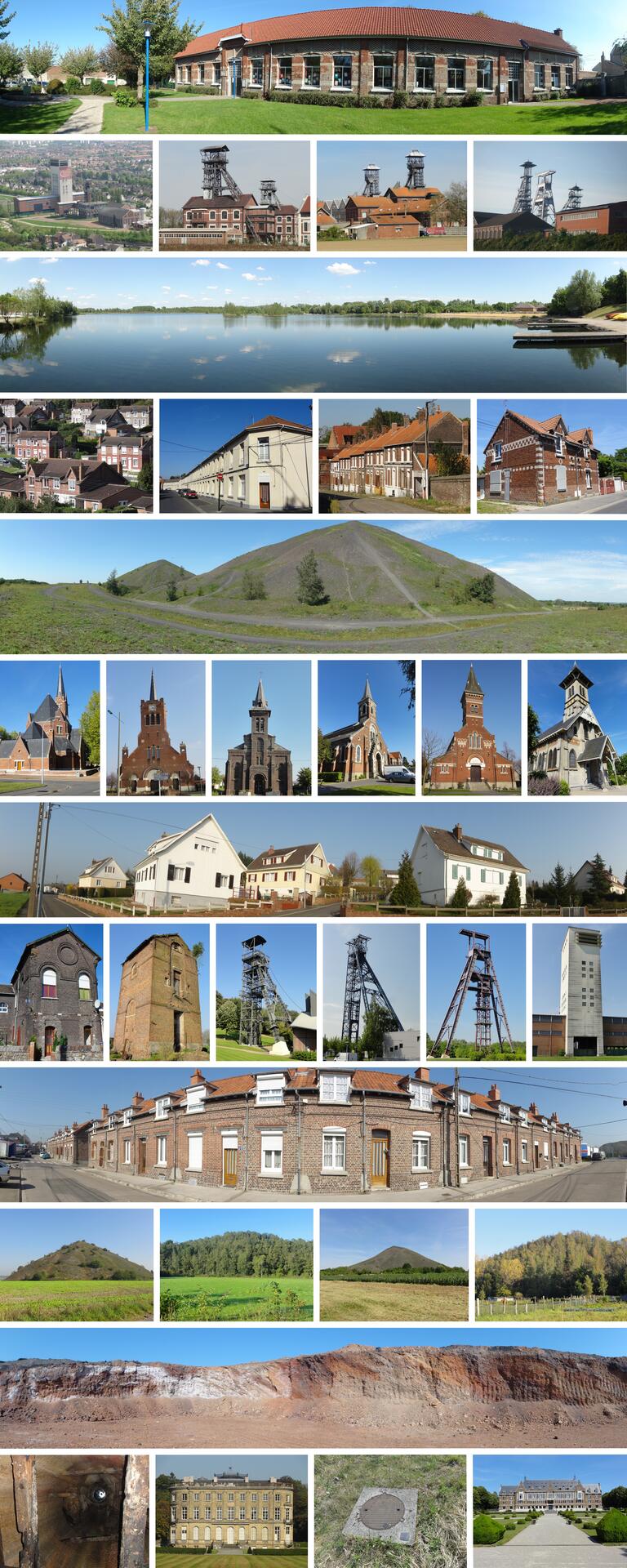
The Nord-Pas de Calais Mining Basin, located in the northern regions of France, stands as a remarkable testament to the industrial revolution and the development of modern Europe. Inscribed as a UNESCO World Heritage Site in 2012, this expansive mining basin spans over 120,000 hectares and comprises 109 distinct components, offering a unique insight into the lives, working conditions, and societal structures that emerged from three centuries of coal extraction, from the late 17th century through the 20th century.
More to come…UNESCO Description of the World Heritage Site
Remarkable as a landscape shaped over three centuries of coal extraction from the 1700s to the 1900s, the site consists of 109 separate components over 120,000 ha. It features mining pits (the oldest of which dates from 1850) and lift infrastructure, slag heaps (some of which cover 90 ha and exceed 140 m in height), coal transport infrastructure, railway stations, workers’ estates and mining villages including social habitat, schools, religious buildings, health and community facilities, company premises, owners and managers’ houses, town halls and more. The site bears testimony to the quest to create model workers’ cities from the mid 19th century to the 1960s and further illustrates a significant period in the history of industrial Europe. It documents the living conditions of workers and the solidarity to which it gave rise.
UNESCO Justification of the World Heritage Site
Criterion (ii): The Nord-Pas de Calais Mining Basin provides exceptional testimony to the exchange of ideas and influences regarding the extraction methods used for underground coal seams, the design of worker housing and urban planning, as well as the international human migration that accompanied the industrialization of Europe.
Criterion (iv): The living and evolving mining landscapes of the Nord-Pas de Calais Basin provide an eminent example of the large-scale development of coal mining in the 19th and 20th centuries, by large industrial companies and their considerable workforce. This is a space structured by urban planning, specific industrial structures and the physical vestiges of coal extraction (slag heaps and subsidence).
Criterion (vi): The social, technical and cultural events associated with the history of the Mining Basin had international repercussions. They are a unique and exceptional illustration of the danger of mine-working and of the history of its major disasters (Courrières). They are testimony to the evolution of the social and technical conditions of coal extraction. They represent a major symbolic place of the workers’ condition and their solidarity, from the 1850s to 1990. They are testimony to the dissemination of the ideals of worker unionism and socialism.
Encyclopedia Record: Nord-Pas de Calais Mining Basin
The Nord-Pas-de-Calais Mining Basin is a mining basin in Northern France that stretches across the Nord and Pas-de-Calais departments. The region is famous for its long history of coal extraction and its testimony to a significant period in the history of industrialisation in Europe, and as a result it was inscribed on the UNESCO World Heritage List in 2012. This area has been shaped by three centuries of coal extraction from the late 17th century through the 20th century, and demonstrates the evolution of coal mining techniques and worker conditions during that time.Additional Site Details
Area: 3,943 hectares
Number of Components: 108
(iv) — Outstanding example of a type of building or landscape
(vi) — Directly associated with events or living traditions
Coordinates: 50.4625 , 3.5461111111