World Heritage Identification Number: 1362
World Heritage since: 2011
Category: Natural Heritage
WHE Type: Natural Landscapes & Geographic Features
Transboundary Heritage: No
Endangered Heritage: No
Country: 🇯🇵 Japan
Continent: Asia
UNESCO World Region: Asia and the Pacific
Map
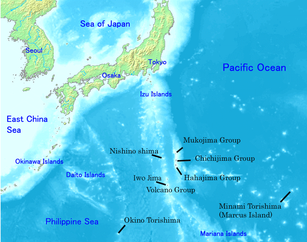
Ogasawara Islands: A Biodiverse Archipelago in the Pacific Ocean
The Ogasawara Islands, officially recognized as a UNESCO World Heritage Site since 2011, constitute a unique and captivating collection of over 30 subtropical and tropical islands scattered across the Pacific Ocean. Situated approximately 1,000 kilometers south-southeast of Tokyo and 1,600 kilometers northwest of Guam, this remote Japanese archipelago offers a diverse array of landscapes and thriving ecosystems that harbor a remarkable assortment of flora and fauna.
More to come…UNESCO Description of the World Heritage Site
The property numbers more than 30 islands clustered in three groups and covers surface area of 7,939 hectares. The islands offer a variety of landscapes and are home to a wealth of fauna, including the Bonin Flying Fox, a critically endangered bat, and 195 endangered bird species. Four-hundred and forty-one native plant taxa have been documented on the islands whose waters support numerous species of fish, cetaceans and corals. Ogasawara Islands' ecosystems reflect a range of evolutionary processes illustrated through its assemblage of plant species from both southeast and northwest Asia, alongside many endemic species.
UNESCO Justification of the World Heritage Site
Criterion (ix): The property's ecosystems reflect a range of evolutionary processes illustrated through its rich assemblage of plant species from both a Southeast Asian and a Northeast Asian origin. There is also a very high percentage of endemic species in selected taxonomic groups, resulting from these evolutionary processes. Within the flora it is an important centre for active, ongoing speciation. The Ogasawara Islands provide valuable evidence of evolutionary processes through their significant on-going ecological processes of adaptive radiation in the evolution of the land snail fauna as well as in their endemic plant species. The examples of fine-scale adaptive radiation between and sometimes within the different islands of the archipelago are central to the study and understanding of speciation and ecological diversification. This is further enhanced by the relatively low extinction rates in taxa such as the land snails. It is the combination of both the concentration of endemism and extent of adaptive radiation evident in the Ogasawara Islands which sets the property apart from other places illustrating evolutionary processes. When taking into account their small area, the Ogasawara Islands show exceptionally high levels of endemism in land snails and vascular plants.
Encyclopedia Record: Bonin Islands
The Bonin Islands, also known as the Ogasawara Islands , is a Japanese archipelago of over 30 subtropical and tropical islands located around 1,000 kilometers (620 mi) SSE of Tokyo and 1,600 kilometers (1,000 mi) northwest of Guam. The group as a whole has a total area of 84 square kilometers (32 sq mi) but only two of the islands are permanently inhabited, Chichijima and Hahajima. Together, their population was 2,560 as of 2021. Administratively, Tokyo's Ogasawara Subprefecture also includes the settlements on the Volcano Islands and the Self-Defense Force post on Iwo Jima. The seat of government is Chichijima.Additional Site Details
Area: 7,939 hectares
Number of Components: 19
Coordinates: 27.7183333333 , 142.0997222222
IUCN World Heritage Outlook
The 2025 Conservation Outlook on Ogasawara Islands reports the following assessment:
Source: International Union for Conservation of Nature (IUCN) · View assessment
Image
Unknown, Public domain
