World Heritage Identification Number: 1349
World Heritage since: 2010
Category: Cultural Heritage
WHE Type: Historic Cities & Urban Areas
Transboundary Heritage: No
Endangered Heritage: No
Country: 🇳🇱 Netherlands (Kingdom of the)
Continent: Europe
UNESCO World Region: Europe and North America
Map
The Seventeenth-Century Canal Ring Area of Amsterdam inside the Singelgracht: A Masterpiece of Urban Planning
The Seventeenth-Century Canal Ring Area of Amsterdam inside the Singelgracht, inscribed as a UNESCO World Heritage Site in 2010, stands as a testament to the ingenuity and foresight of the Dutch Golden Age. This historic urban ensemble, located in the heart of Amsterdam, offers a unique blend of urban planning, architectural distinction, and cultural significance that has captivated visitors for centuries.
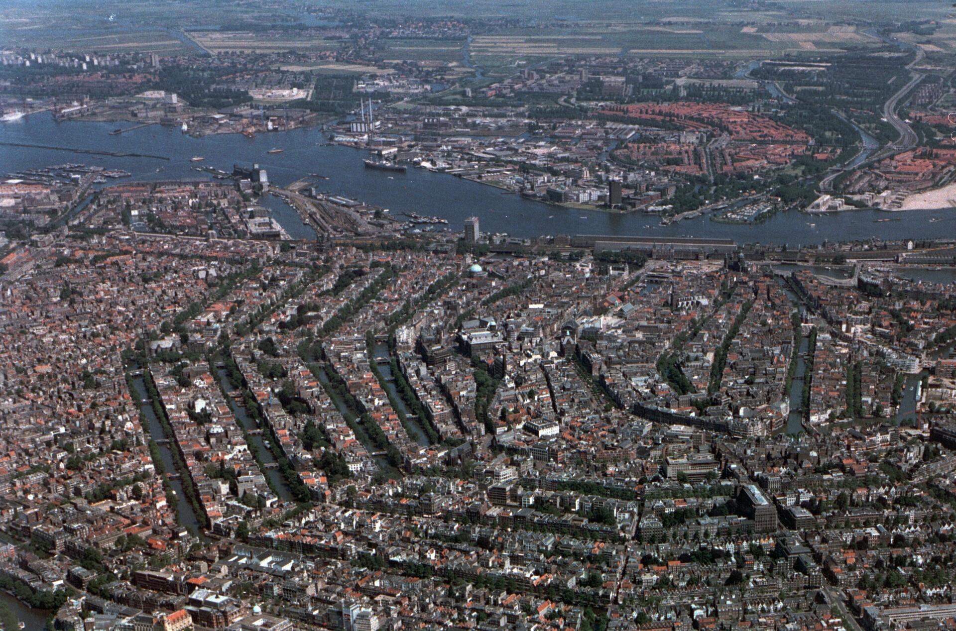
The Canal Ring Area, also known locally as the Grachtengordel, is a neighborhood situated within the Centrum district. It encompasses a network of concentric canals—the Singel, Herengracht, Keizersgracht, Prinsengracht, and several smaller ones—that encircle the historic old town and the medieval port. While the Singel dates back to the Middle Ages as a city moat, the systematic expansion of the three main outer canals began in 1613, forming part of a larger plan to extend Amsterdam’s urban area onto reclaimed land, integrating transportation, water management, and city defense.
The creation of this urban extension was a monumental undertaking. The city expanded its boundaries by draining surrounding marshy land and laying out a system of canals in concentric arcs. The spaces between these waterways facilitated the development of a harmonious and homogeneous urban ensemble characterized by gabled houses, axial streets, and numerous monuments. This extensive project was one of the largest and most coherent examples of town planning of its time and served as a model for large‑scale urban design throughout the world until the 19th century.
The Canal Ring Area is renowned for its architectural uniformity and its large number of monumental buildings. Many canal houses date back to the Dutch Golden Age, illustrating the prosperity of Amsterdam during this period of maritime trade and cultural flourishing. The facades are typically adorned with gables and exhibit a variety of stylistic details that reflect developments in architecture from the 17th and 18th centuries.
The canal network was not only an architectural and urban planning achievement but also a vital part of Amsterdam’s economic and social life. The waterways enabled the efficient transport of goods and people throughout the city, linking merchants, warehouses, and marketplaces while supporting the city’s thriving maritime trade. Beyond commerce, the canals shaped daily life, providing spaces for recreation, social interaction, and local festivals.
While the Canal Ring remains fundamentally a residential and commercial district, it also features important individual landmarks such as the Westerkerk in the city, and the Anne Frank House. In addition to these iconic sites, the area contains other historic churches, squares, museums, and cultural venues that reflect Amsterdam’s long-standing cultural heritage. The wider area around the canal belt continues to be vibrant with everyday life, hosting shops, cafes, galleries, and regular cultural events that draw both locals and visitors.
The Seventeenth‑Century Canal Ring Area of Amsterdam inside the Singelgracht is more than just a collection of beautiful buildings and winding waterways. It represents a remarkable achievement in urban planning and hydraulic engineering, a testament to human creativity and civic ambition, and a living embodiment of Amsterdam’s historical evolution. A visit to this UNESCO World Heritage Site offers a glimpse into the city’s Golden Age while immersing visitors in the present‑day charm and vitality of one of Europe’s most captivating urban landscapes.
UNESCO Description of the World Heritage Site
The historic urban ensemble of the canal district of Amsterdam was a project for a new ‘port city’ built at the end of the 16th and beginning of the 17th centuries. It comprises a network of canals to the west and south of the historic old town and the medieval port that encircled the old town and was accompanied by the repositioning inland of the city’s fortified boundaries, the Singelgracht. This was a long-term programme that involved extending the city by draining the swampland, using a system of canals in concentric arcs and filling in the intermediate spaces. These spaces allowed the development of a homogeneous urban ensemble including gabled houses and numerous monuments. This urban extension was the largest and most homogeneous of its time. It was a model of large-scale town planning, and served as a reference throughout the world until the 19th century.
UNESCO Justification of the World Heritage Site
Criterion (i): The Amsterdam Canal District is the design at the end of the 16th century and the construction in the 17th century of a new and entirely artificial ‘port city.’ It is a masterpiece of hydraulic engineering, town planning, and a rational programme of construction and bourgeois architecture. It is a unique and innovative, large-scale but homogeneous urban ensemble.
Criterion (ii): The Amsterdam Canal District bears witness to an exchange of considerable influences over almost two centuries, in terms not only of civil engineering, town planning, and architecture, but also of a series of technical, maritime, and cultural fields. In the 17th century Amsterdam was a crucial centre for international commercial trade and intellectual exchange, for the formation and the dissemination of humanist thought; it was the capital of the world-economy in its day.
Criterion (iv): The Amsterdam Canal District represents an outstanding example of a built urban ensemble that required and illustrates expertise in hydraulics, civil engineering, town planning, construction and architectural knowhow. In the 17th century, it established the model for the entirely artificial ‘port city’ as well as the type of Dutch single dwelling with its variety of façades and gables. The city is testimony, at the highest level, to a significant period in the history of the modern world.
Encyclopedia Record: Grachtengordel
The Grachtengordel, known in English as the Canal District, is a neighborhood in Amsterdam, Netherlands located in the Centrum district. The seventeenth-century canals of Amsterdam, located in the center of Amsterdam, were added to the UNESCO World Heritage List in August 2010. The Amsterdam Canal District consists of the area around the city's four main canals: the Singel, the Herengracht, the Keizersgracht, and the Prinsengracht. From the Brouwersgracht, the canals are generally parallel with one another, leading gradually southeast into the Amstel river.Additional Site Details
Area: 198.2 hectares
Number of Components: 1
(ii) — Significant interchange of human values
(iv) — Outstanding example of a type of building or landscape
Coordinates: 52.365 , 4.8877777778
Image
© Amsterdam Municipal Department for the Preservation and Restoration of Historic Buildings and Sites (bMA). The author is BMZ (Bureau Monumentenzorg). Original uploader was Siebrand at nl.wikipedia Later version(s) were uploaded by Eriksw at nl.wikipedia., Attribution Resized from original.
