World Heritage Identification Number: 759
World Heritage since: 1996
Category: Cultural Heritage
WHE Type: Infrastructure & Industry
Transboundary Heritage: No
Endangered Heritage: No
Country: 🇳🇱 Netherlands (Kingdom of the)
Continent: Europe
UNESCO World Region: Europe and North America
Map
The Dutch Water Defence Lines: A Unique Hydraulic Engineering Approach to Protecting the Netherlands
The Dutch Water Defence Lines, inscribed as a UNESCO World Heritage Site in 1996, represent a remarkable example of hydraulic engineering for defensive purposes in the Netherlands. Spanning over 200 kilometers along the country's administrative and economic core, this extensive defence system includes the New Dutch Waterline and the Defence Line of Amsterdam. Developed between 1815 and 1940, it showcases the unique Dutch expertise in water management and defence strategies that have been honed since the 16th century.
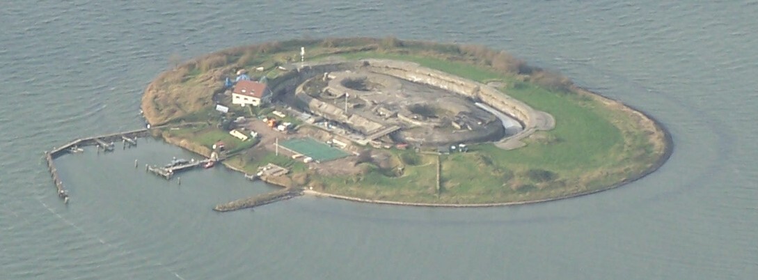
The Defence Line of Amsterdam, a significant component of the Dutch Water Defence Lines, is a complex network of forts, dikes, sluices, pumping stations, canals, and inundation polders. These elements work together to protect the Netherlands from potential invasion threats. The system's primary strategy involves temporarily flooding the land to create a barrier against enemy forces. This innovative approach to defence is rooted in the Dutch historical experience with flood control and water management.
Each polder along the defence line features its own inundation facilities, ensuring efficient protection against external threats. In times of crisis, these facilities are activated to flood the surrounding areas, creating a formidable barrier. Once the threat has passed, the water is drained back into the rivers and canals, allowing normal life to resume.
The New Dutch Waterline, which was added to the World Heritage Site in 2021, extends the defensive capabilities of the original system. With the final concrete structures built between 1932 and 1940, it covers some 85 kilometers and includes several new fortified positions, dikes, and other defensive structures. The New Dutch Waterline was designed to protect the densely populated and industrialized areas around Utrecht, Haarlem, and Amersfoort from potential invasions.
The Dutch Water Defence Lines owe their existence to the Netherlands' long history of dealing with water. Since the 16th century, the Dutch have employed ingenious methods to reclaim land from the sea and protect themselves from flooding. This expertise in hydraulic engineering has been adapted for defensive purposes, resulting in the creation of the Dutch Water Defence Lines.
The Dutch Water Defence Lines stand as a testament to the ingenuity and resilience of the Dutch people. Their ability to adapt to the challenges posed by their geographical location and to develop advanced systems for protecting their lands has made them a source of inspiration and admiration around the world. Today, the Dutch Water Defence Lines continue to serve as a vital protective measure, safeguarding the Netherlands from potential threats while preserving its rich cultural heritage.
UNESCO Description of the World Heritage Site
The Dutch Water Defence Lines represents a defence system extending over 200 km along the edge of the administrative and economic heartland of Holland. It is comprised of the New Dutch Waterline and the Defence Line of Amsterdam. Built between 1815 and 1940, the system consists of a network of forts, dikes, sluices, pumping stations, canals and inundation polders, working in concert to protect the Netherlands by applying the principle of temporary flooding of the land. It has been developed thanks to the special knowledge of hydraulic engineering for defence purposes held and applied by the people of the Netherlands since the 16th century. Each of the polders along the line of fortifications has its own inundation facilities.
UNESCO Justification of the World Heritage Site
Criterion (ii): The Dutch Water Defence Lines are an illustration of an extensive integrated European defence system of the modern period which survived intact and well conserved since their creation in the beginning of the 19th century. They are part of a continuum of defensive measures that both preceded their construction and were later to influence some portions of them immediately before and after World War II.
Criterion (iv): The Dutch Water Defence Lines are an outstanding example of an extensive and ingenious system of military defence by inundation, that uses features and elements of the country’s landscape. The well-preserved collection of fortifications in the context of the surrounding landscape is unique in the European history of military architecture. The forts illustrate the development of military architecture between 1815 and 1940, in particular the transition from brick construction to the use of reinforced concrete in the Defence Line of Amsterdam. This transition, with its experiments in the use of concrete and emphasis on the use of non-reinforced concrete, is an episode in the history of European architecture of which material remains are only rarely preserved.
Criterion (v): The Dutch Water Defence Lines form an extraordinary example of the Dutch expertise in landscape design and hydraulic engineering. They are notable for the unique way in which hydraulic engineering has been incorporated into the defences of the administrative and economic heartland of the country, including the nation’s capital city.
Encyclopedia Record: Dutch Water Defence Lines
The Dutch Water Defence lines is a UNESCO World Heritage Site in the Netherlands comprising the New Dutch Waterline and Stelling van Amsterdam. The Stelling van Amsterdam was added as a World Heritage Site in 1996, and was extended in 2021 with the New Dutch Waterline in 2021.Additional Site Details
Area: 55,404.9 hectares
Number of Components: 20
(iv) — Outstanding example of a type of building or landscape
(v) — Outstanding example of traditional human settlement
Coordinates: 52.555 , 4.7913888889
Image
© Debot at Dutch Wikipedia, CC BY-SA 3.0 Resized from original. (This derivative is under the same CC BY-SA license.)
