World Heritage Identification Number: 1416
World Heritage since: 2014
Category: Natural Heritage
WHE Type: Natural Landscapes & Geographic Features
Transboundary Heritage: No
Endangered Heritage: No
Country: 🇩🇰 Denmark
Continent: Europe
UNESCO World Region: Europe and North America
Map
Stevns Klint: A Geological Testimony to the Cretaceous-Paleogene Extinction Event
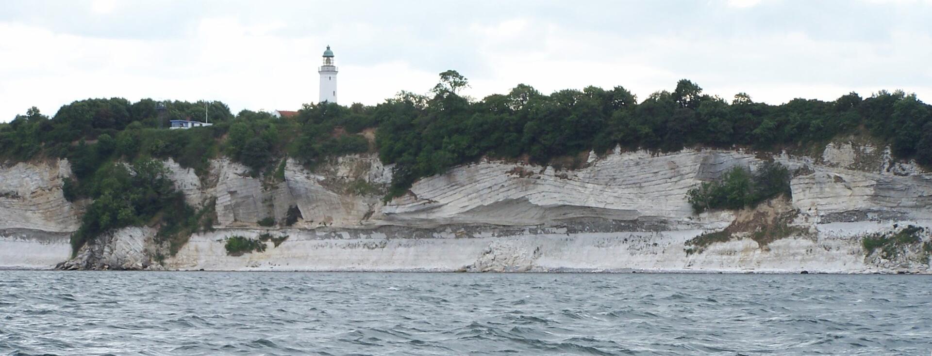
Stevns Klint, situated on the Danish island of Zealand, offers a unique glimpse into the Earth's history, making it a significant addition to the UNESCO World Heritage List in 2014. Known colloquially as the Cliffs of Stevns, this 17-kilometer-long white chalk cliff stands as a testament to the Cretaceous-Paleogene (K/P) extinction event, which occurred approximately 65 million years ago.
More to come…UNESCO Description of the World Heritage Site
This geological site comprises a 15 km-long fossil-rich coastal cliff, offering exceptional evidence of the impact of the Chicxulub meteorite that crashed into the planet at the end of the Cretaceous, about 65 million years ago. Researchers think that this caused the most remarkable mass extinction ever, responsible for the disappearance of over 50 per cent of all life on Earth. The site harbours a record of the cloud of ash formed by the impact of the meteorite – the exact site being at the bottom of the ocean off the coast of Mexico’s Yucatán Peninsula. An exceptional fossil record is visible at the site, showing the complete succession of fauna and micro-fauna charting the recovery after the mass extinction.
UNESCO Justification of the World Heritage Site
Criterion (viii): Stevns Klint is a globally exceptional testimony to the impact of meteorite impact on the history of life on Earth. The property provides a globally exceptional representation of the evidence of the Chixulub meteorite impact that took place at the end of the Cretaceous Period, c.67 million years ago. This impact is widely believed by modern scientists to have caused the end of the Age of the Dinosaurs, and led to the extinction of more than 50% of life on Earth. This is the most recent of the major mass extinctions in Earth’s history. Comparative analysis indicates this is the most significant and readily accessible site, of hundreds available, to see the sedimentary record of the ash cloud formed by the meteorite impact, the actual site of the impact being deep underwater offshore the Yucatan peninsula. In addition, the site has iconic scientific importance as the most significant and accessible of the three localities where the radical theory for asteroid driven extinction was developed through the seminal work of Walter and Luis W Alvarez, with their co-workers. Stevns Klint is highly significant in terms of its past, present and future contribution to science especially pertaining to the definition of and explanation of the Cretaceous/Tertiary (K/T) boundary. The outstanding fossil record at Stevns Klint provides a succession of three biotic assemblages including the most diverse end-Cretaceous marine ecosystem known. The million years recorded in the rock at Stevns Klint provides evidence of a climax pre-impact community, fauna that survived a mass extinction event, and the subsequent faunal recovery and increased biodiversity following this event. The fossil record shows which taxa became extinct and which survived and reveals the tempo and mode of evolution of the succeeding post impact fauna that diversified to the marine fauna of today, thus providing important context for the main K/T boundary layer exposed at Stevns Klint.
Encyclopedia Record: Stevns Klint
Stevns Klint, known as the Cliffs of Stevns in English, is a white chalk cliff located some 6 km (3.7 mi) southeast of Store Heddinge on the Danish island of Zealand. Stretching 17 km (11 mi) along the coast, it is of geological importance as one of the best exposed Cretaceous-Tertiary (K/T) boundaries in the world. Subject to frequent erosion, the cliff rises to a height of up to 40 m (130 ft). Because of its exceptional fossil record, Stevns Klint was inscribed on the UNESCO World Heritage List in 2014.Additional Site Details
Area: 50 hectares
Number of Components: 1
Coordinates: 55.2672222222 , 12.4233333333
IUCN World Heritage Outlook
The 2025 Conservation Outlook on Stevns Klint reports the following assessment:
Source: International Union for Conservation of Nature (IUCN) · View assessment
Image
© Niels Elgaard Larsen, CC BY-SA 3.0 Resized from original. (This derivative is under the same CC BY-SA license.)
