World Heritage Identification Number: 1179
World Heritage since: 2008
Category: Natural Heritage
WHE Type: Natural Landscapes & Geographic Features
Transboundary Heritage: No
Endangered Heritage: No
Country: 🇨🇭 Switzerland
Continent: Europe
UNESCO World Region: Europe and North America
Map
Swiss Tectonic Arena Sardona: A Geological Marvel in Eastern Switzerland
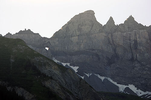
The Swiss Tectonic Arena Sardona, inscribed as a UNESCO World Heritage Site in 2008, offers a unique insight into the intricate workings of continental collision and mountain building. Situated in the northeastern part of Switzerland, the site spans an expansive area of approximately 32,850 hectares, featuring seven peaks that tower above 3,000 meters.
More to come…UNESCO Description of the World Heritage Site
The Swiss Tectonic Arena Sardona in the north-eastern part of the country covers a mountainous area of 32,850 ha which features seven peaks that rise above 3,000 m. The area displays an exceptional example of mountain building through continental collision and features .excellent geological sections through tectonic thrust, i.e. the process whereby older, deeper rocks are carried onto younger, shallower rocks. The site is distinguished by the clear three-dimensional exposure of the structures and processes that characterize this phenomenon and has been a key site for the geological sciences since the 18th century. The Glarus Alps are glaciated mountains rising dramatically above narrow river valleys and are the site of the largest post-glacial landslide in the Central Alpine region.
UNESCO Justification of the World Heritage Site
Criterion (viii): Earth’s history, geological and geomorphic features and processes: The Swiss Tectonic Arena Sardona provides an exceptional display of mountain building tectonics and has been recognised as a key site for geological sciences since the 18th century. The clear exposure of the Glarus Overthrust is a key, but not the only significant, feature. The exposures of the rocks below and above this feature are visible in three dimensions and, taken together, have made substantial contributions to the understanding of mountain building tectonics. Its geological features can be readily appreciated by all visitors. The property can be differentiated from other similar sites by the combination of the clear exposure of the phenomenon in a mountain setting, its history of study, and its ongoing contribution to geological sciences.
Encyclopedia Record: Glarus thrust
The Glarus thrust is a major thrust fault in the Alps of eastern Switzerland. Along the thrust the Helvetic nappes were thrust more than 100 km to the north over the external Aarmassif and Infrahelvetic complex. The thrust forms the contact between older (Helvetic) Permo-Triassic rock layers of the Verrucano group and younger (external) Jurassic and Cretaceous limestones and Paleogene flysch and molasse.Additional Site Details
Area: 32,850 hectares
Number of Components: 1
Coordinates: 46.9166666667 , 9.25
IUCN World Heritage Outlook
The 2025 Conservation Outlook on Swiss Tectonic Arena Sardona reports the following assessment:
Source: International Union for Conservation of Nature (IUCN) · View assessment
Image
© 
