World Heritage Identification Number: 1450
World Heritage since: 2018
Category: Cultural Heritage
WHE Type: Archaeological Sites
Transboundary Heritage: No
Endangered Heritage: No
Country: 🇰🇪 Kenya
Continent: Africa
UNESCO World Region: Africa
Map
Thimlich Ohinga Archaeological Site: A Remarkable Testament to Ancient Pastoral Communities in Kenya
The Thimlich Ohinga Archaeological Site, located in the Lake Victoria region of Migori County, Kenya, stands as a remarkable testament to the ancient pastoral communities that once thrived in the area. Inscribed as a UNESCO World Heritage Site in 2018, this unique settlement offers valuable insights into the social, cultural, and economic practices of these early communities.
More to come…UNESCO Description of the World Heritage Site
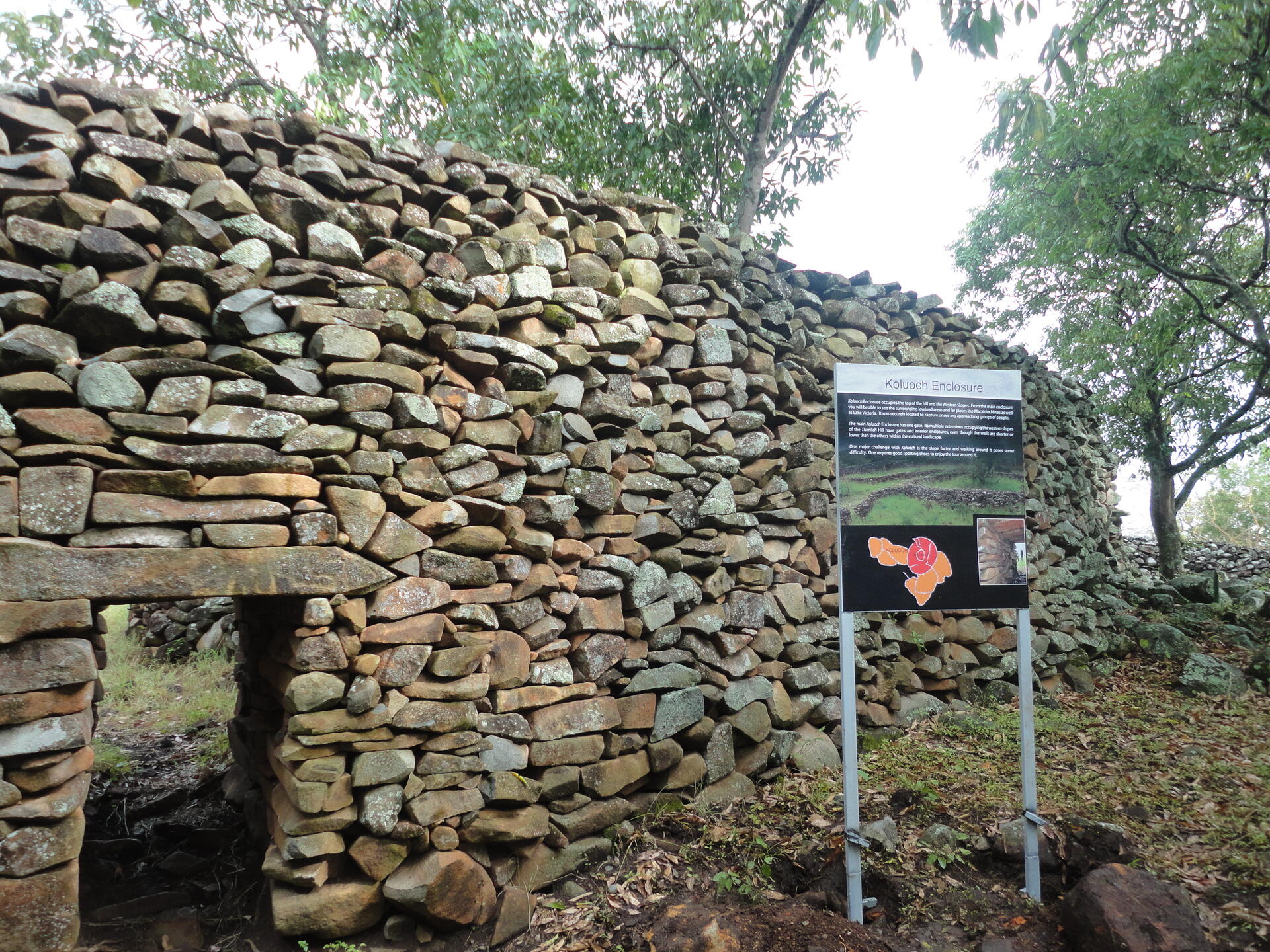
Situated north-west of the town of Migori, in the Lake Victoria region, this dry-stone walled settlement was probably built in the 16th century CE. The Ohinga (i.e. settlement) seems to have served as a fort for communities and livestock, but also defined social entities and relationships linked to lineage. Thimlich Ohinga is the largest and best preserved of these traditional enclosures. It is an exceptional example of the tradition of massive dry-stone walled enclosures, typical of the first pastoral communities in the Lake Victoria Basin, which persisted from the 16th to the mid-20th century.
UNESCO Justification of the World Heritage Site
Criterion (iii): Thimlich Ohinga provides an exceptional testimony to settlement traditions in the Lake Victoria Basin. It illustrates shared communal settlement, livestock cultivation and craft industry patterns, utilized and practiced by several successive inhabitant groups of different linguistic origin. The archaeological evidence testified not only to the communities’ spatial organization but also to an elaborate system of interrelations between the different Ohingni within proximity to each other. It therefore allows to understand and further research community interaction patterns between the 16th and the mid-20th century in the region.
Criterion (iv): The settlements of Thimlich Ohinga provide an impressive reference to spatial planning and settlement types in the wider Lake Victoria Basin, at a period in history characterized by increased human mobility as a result of social, economic and environmental pressures that affected human populations in the region. The massive stone walled enclosures at Thimlich Ohinga mark an important episode in the migration and settlement of the Lake Victoria Basin and sub-Saharan Africa as a whole. Thimlich Ohinga also illustrates an outstanding example of undressed dry-stone construction typology characterized by a three-phase building technology using stones of irregular shapes in two phases joined together by a third middle phase.
Criterion (v): Thimlich Ohinga, as the best preserved example of Ohingni constitutes a representative and outstanding example of Ohingni, a distinctive form of pastoral settlement that persisted in the Lake Victoria Basin from the 16th to the mid-20th centuries.
Encyclopedia Record: Thimlich Ohinga
Thimlich Ohinga is a complex of stone-built ruins in Migori county, Nyanza Kenya, in East Africa. It is the largest one of 138 sites containing 521 stone structures that were built around the Lake Victoria region in Kenya. These sites are highly clustered. The main enclosure of Thimlich Ohinga has walls that are 1–3 m (3.3–9.8 ft) in thickness, and 1–4.2 m (3.3–13.8 ft) in height. The structures were built from undressed blocks, rocks, and stones set in place without mortar. The densely packed stones interlock. The site is believed to date to the 15th century or earlier.Additional Site Details
Area: 21 hectares
Number of Components: 1
(iv) — Outstanding example of a type of building or landscape
(v) — Outstanding example of traditional human settlement
Coordinates: -0.8913380556 , 34.326107
Image
© Wycondi, CC BY-SA 3.0 Resized from original. (This derivative is under the same CC BY-SA license.)
