World Heritage Identification Number: 1083
World Heritage since: 2003
Category: Natural Heritage
WHE Type: Protected Areas & National Parks
Transboundary Heritage: No
Endangered Heritage: No
Country: 🇨🇳 China
Continent: Asia
UNESCO World Region: Asia and the Pacific
Map
A Journey Through the Three Parallel Rivers of Yunnan Protected Areas
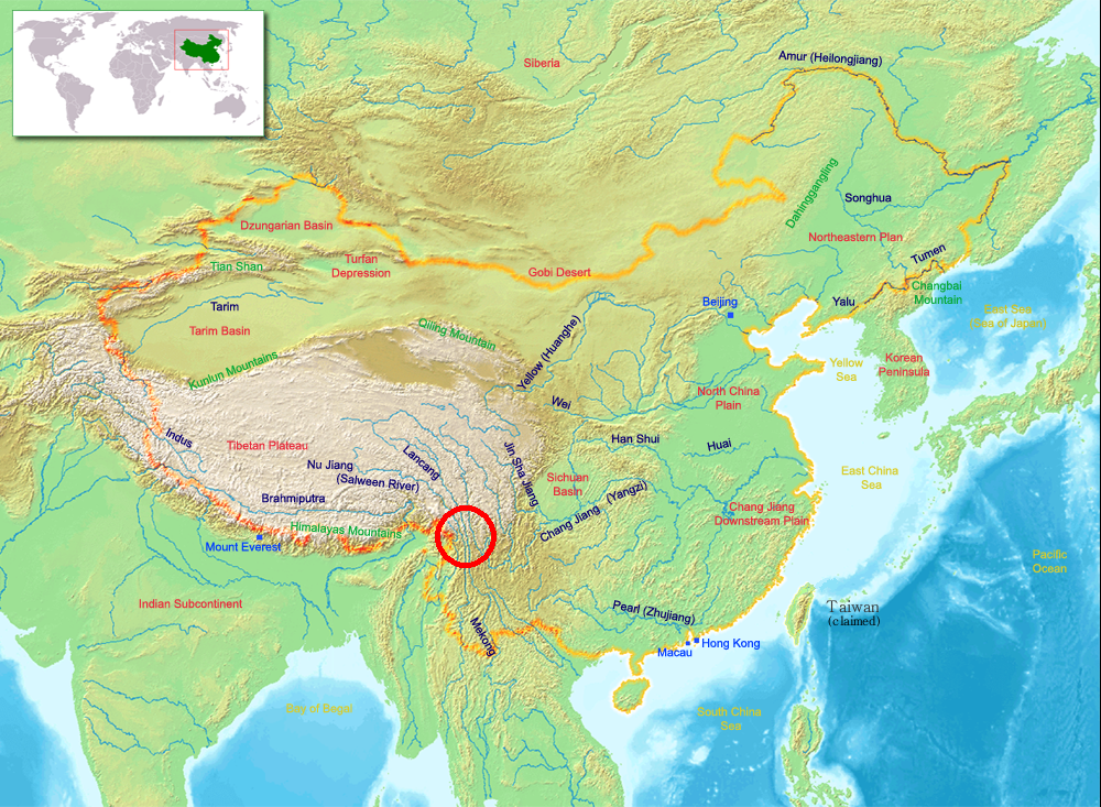
The Three Parallel Rivers of Yunnan Protected Areas, inscribed as a UNESCO World Heritage Site in 2003, offers a unique exploration into the rich biodiversity and breathtaking landscapes of China's Yunnan Province. This expansive region, spanning approximately 1.7 million hectares, is situated within the boundaries of the Three Parallel Rivers National Park and encompasses sections of the upper reaches of three of Asia's greatest rivers: the Yangtze (Jinsha), Mekong, and Salween. These mighty waterways, running roughly parallel from north to south, carve their paths through steep gorges that reach depths of up to 3,000 meters and are flanked by towering peaks surpassing 6,000 meters.
More to come…UNESCO Description of the World Heritage Site
Consisting of eight geographical clusters of protected areas within the boundaries of the Three Parallel Rivers National Park, in the mountainous north-west of Yunnan Province, the 1.7 million hectare site features sections of the upper reaches of three of the great rivers of Asia: the Yangtze (Jinsha), Mekong and Salween run roughly parallel, north to south, through steep gorges which, in places, are 3,000 m deep and are bordered by glaciated peaks more than 6,000 m high. The site is an epicentre of Chinese biodiversity. It is also one of the richest temperate regions of the world in terms of biodiversity.
UNESCO Justification of the World Heritage Site
Criterion (vii): The deep, parallel gorges of the Jinsha, Lancang and Nu Jiang are the outstanding natural feature of the property; while large sections of the three rivers lie just outside the property boundaries, the river gorges are nevertheless the dominant scenic element in the area. High mountains are everywhere, with the glaciated peaks of the Meili, Baima and Haba Snow Mountains providing a spectacular scenic skyline. The Mingyongqia Glacier is a notable natural phenomenon, descending to 2700 m altitude from Mt Kawagebo (6740 m), and is claimed to be the glacier descending to the lowest altitude for such a low latitude (28° N) in the northern hemisphere. Other outstanding scenic landforms are the alpine karst (especially the 'stone moon' in the Moon Mountain Scenic Area above the Nu Jiang Gorge) and the 'tortoise shell' weathering of the alpine Danxia.
Criterion (viii): The property is of outstanding value for displaying the geological history of the last 50 million years associated with the collision of the Indian Plate with the Eurasian Plate, the closure of the ancient Tethys Sea, and the uplifting of the Himalaya Range and the Tibetan Plateau. These were major geological events in the evolution of the land surface of Asia and they are on-going. The diverse rock types within the property record this history and, in addition, the range of karst, granite monolith, and Danxia sandstone landforms in the alpine zone include some of the best of their type in the mountains of the world.
Criterion (ix): The dramatic expression of ecological processes in the Three Parallel Rivers property has resulted from a mix of geological, climatic and topographical effects. First, the location of the area within an active orographic belt has resulted in a wide range of rock substrates from igneous (four types) through to various sedimentary types including limestones, sandstones and conglomerates. An exceptional range of topographical features - from gorges to karst to glaciated peaks -- is associated with the property being at a collision point of tectonic plates. Add the fact that the area was a Pleistocene refugium and is located at a biogeographical convergence zone (i.e. with temperate and tropical elements) and the physical foundations for evolution of its high biodiversity are all present. Along with the landscape diversity with a steep gradient of almost 6000m vertical, a monsoon climate affects most of the area and provides another favourable ecological stimulus that has allowed the full range of temperate Palearctic biomes to develop.
Criterion (x): Northwest Yunnan is the area of richest biodiversity in China and may be the most biologically diverse temperate region on earth. The property encompasses most of the natural habitats in the Hengduan Mountains, one of the world's most important remaining areas for the conservation of the earth's biodiversity. The outstanding topographic and climatic diversity of the property, coupled with its location at the juncture of the East Asia, Southeast Asia, and Tibetan Plateau, biogeographical realms and its function as a N-S corridor for the movement of plants and animals (especially during the ice ages), marks it as a truly unique landscape, which still retains a high degree of natural character despite thousands of years of human habitation. As the last remaining stronghold for an extensive suite of rare and endangered plants and animals, the property is of Outstanding Universal Value.
Encyclopedia Record: Three Parallel Rivers
The Three Parallel Rivers of Yunnan Protected Areas is a UNESCO World Heritage Site in Yunnan province, China. It lies within the drainage basins of the upper reaches of the Jinsha (Yangtze), Lancang (Mekong) and Nujiang (Salween) rivers, in the Yunnan section of the Hengduan Mountains.Additional Site Details
Area: Not available
Number of Components: 1
(viii) — Outstanding example representing major earth stages
(ix) — Outstanding example representing ecological and biological processes
(x) — Contains most important habitats for biodiversity
Coordinates: 27.895 , 98.40638889
IUCN World Heritage Outlook
The 2025 Conservation Outlook on Three Parallel Rivers of Yunnan Protected Areas reports the following assessment:
Source: International Union for Conservation of Nature (IUCN) · View assessment
Image
©
- ChinaGeography.png: en:User:Alanmak Alan Mak
- derivative work: Takeaway (talk)
