World Heritage Identification Number: 1604
World Heritage since: 2019
Category: Natural Heritage
WHE Type: Protected Areas & National Parks
Transboundary Heritage: No
Endangered Heritage: No
Country: 🇮🇸 Iceland
Continent: Europe
UNESCO World Region: Europe and North America
Map
Vatnajökull National Park: A Landscape of Fire and Ice
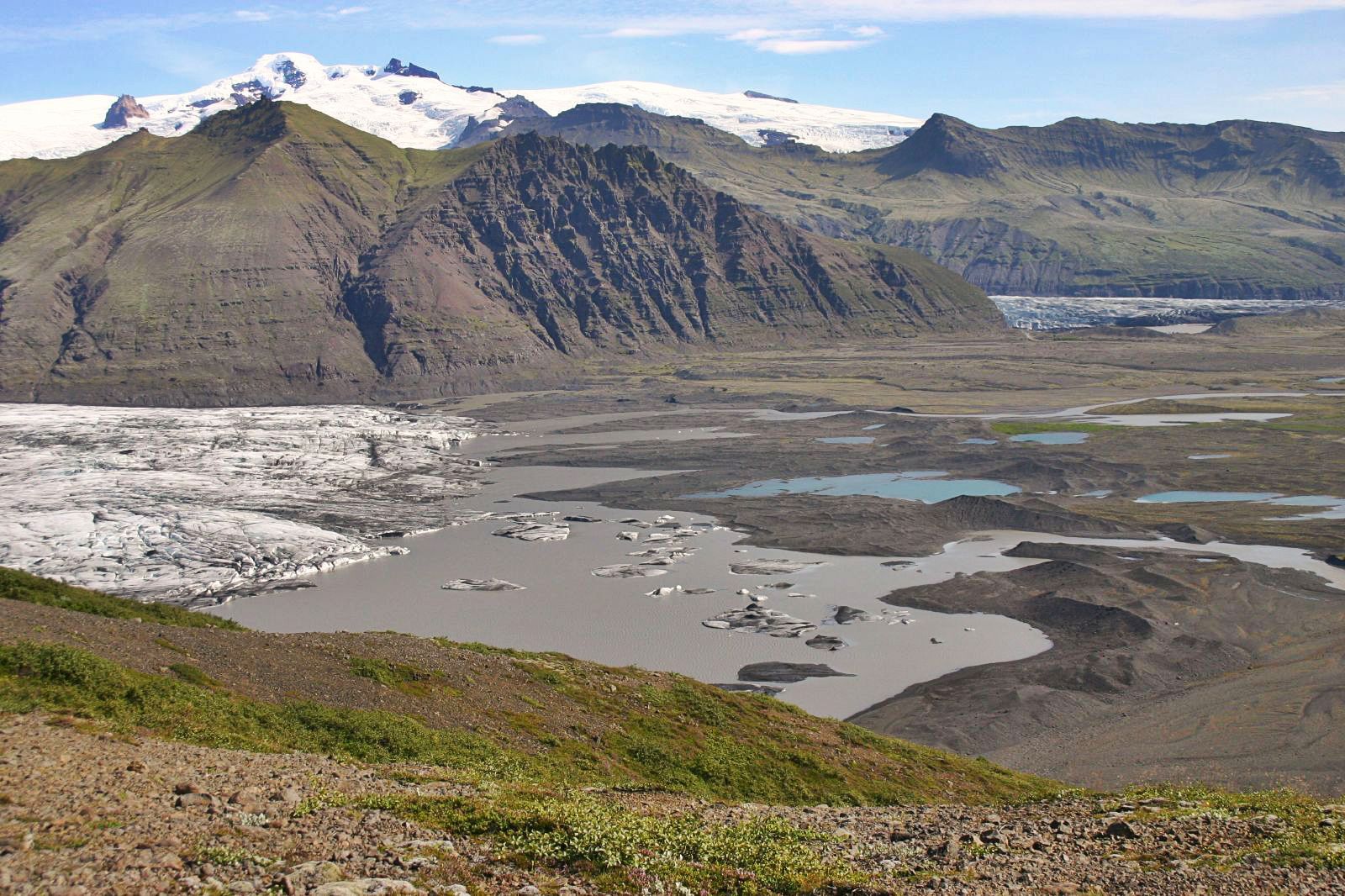
Vatnajökull National Park, officially known as "Vatnajökull National Park - Dynamic Nature of Fire and Ice," is a breathtaking natural wonder located in southeastern Iceland. Covering an expansive area of approximately 1,400,000 hectares, or around 14 percent of Iceland's total territory, it is the country's largest national park and one of its three national parks.
The park's name derives from the vast Vatnajökull glacier, which lies at its heart. This massive ice cap, the largest in Europe, stretches across a diverse landscape that includes ten central volcanoes, eight of which are subglacial. Two of these volcanoes, Grímsvötn and Bárdarbunga, are particularly active, contributing to the dynamic and ever-changing nature of the park.
One of the most striking phenomena associated with this volcanic activity is the jökulhlaup, a sudden flood caused by the breaching of a glacier margin during an eruption. These events have sculpted the park's unique topography, creating sandur plains, river systems, and rapidly evolving canyons. While occasional, jökulhlaups showcase the raw power of Iceland’s “fire and ice” landscape.
In addition to its geological features, Vatnajökull National Park is home to a diverse and unique ecosystem. The volcanic areas within the park provide habitat for endemic groundwater fauna that managed to survive the Ice Age. These unique organisms survive in the park's hot springs, geysers, and other volcanically heated water sources.
The park's northern section, previously known as Jökulsárgljúfur National Park, boasts impressive canyons, waterfalls, and basalt columns. Notable attractions here include Dettifoss, Europe's most powerful waterfall, based on volume of water flow, and Ásbyrgi, a horseshoe-shaped canyon believed to have been formed by ancient glacial floods.
In the southwestern corner, Skaftafell offers visitors a range of hiking trails through lush valleys, past cascading waterfalls, and up to the edge of the glacier itself. The park’s highest peak, Hvannadalshnúkur, rises to 2,110 meters above sea level, providing stunning views of the glaciers, volcanic landscapes, and surrounding wilderness.
Visitors to Vatnajökull National Park can witness firsthand the raw power and beauty of the stunning contrast between ice and volcanic activity. From the tranquil serenity of the glaciers to the explosive energy of the volcanoes, the park offers a unique glimpse into the forces that shaped our planet. As such, it is a must-visit destination for anyone seeking to experience the wonders of nature in all their glory.
UNESCO Description of the World Heritage Site
This iconic volcanic region covers an area of over 1,400,000 ha, nearly 14% of Iceland's territory. It numbers ten central volcanoes, eight of which are subglacial. Two of these are among the most active in Iceland. The interaction between volcanoes and the rifts that underlie the Vatnajökull ice cap takes many forms, the most spectacular of which is the jökulhlaup – a sudden flood caused by the breach of the margin of a glacier during an eruption. This recurrent phenomenon has led to the emergence of unique sandur plains, river systems and rapidly evolving canyons. Volcanic areas are home to endemic groundwater fauna that has survived the Ice Age.
UNESCO Justification of the World Heritage Site
Criterion (viii): The coexistence and ongoing interaction of an active oceanic rift on land, a mantle plume, the atmosphere and an ice cap, which has varied in size and extent over the past 2.8 million years, make the property unique in a global context. Earth system interactions are constantly building and reshaping the property, creating remarkably diverse landscapes and a wide variety of tectonic, volcanic and glaciovolcanic features. Especially interesting and unique in this regard are the basaltic lava shields (Iceland shields), volcanic fissures and cone rows, vast flood lavas, and features of ice dominant glacio-volcanism, such as tuyas and tindar. Interestingly, the well exposed volcanic features of the property have been used as analogues for similar features on the planet Mars. Geothermal heat and subglacial eruptions produce meltwater and jökulhlaups that maintain globally unique sandur plains, to the north and south of the Vatnajökull ice cap, as well as rapidly evolving canyons. In addition, the property contains a dynamic array of glacial- and geomorphological features, created by expanding or retreating glaciers responding to changes in climate. These features can be easily accessed and explored at the snouts of Vatnajökull’s many outlet glaciers and their forelands, especially in the southern lowlands, making the property a flagship glacial research location.
Encyclopedia Record: Vatnajökull National Park
Vatnajökull National Park is one of three national parks in Iceland, and is the largest one. It encompasses all of Vatnajökull glacier and extensive surrounding areas. These include the national parks previously existing at Skaftafell in the southwest and Jökulsárgljúfur in the north.Additional Site Details
Area: 1,482,000 hectares
Number of Components: 1
Coordinates: 64.577363 , -16.8815404444
IUCN World Heritage Outlook
The 2025 Conservation Outlook on Vatnajökull National Park - Dynamic Nature of Fire and Ice reports the following assessment:
Source: International Union for Conservation of Nature (IUCN) · View assessment
Image
© Justraveling.com, CC BY-SA 4.0 Resized from original. (This derivative is under the same CC BY-SA license.)
