World Heritage Identification Number: 1390
World Heritage since: 2014
Category: Cultural Heritage
WHE Type: Agriculture Landscapes, Parks & Gardens
Transboundary Heritage: No
Endangered Heritage: No
Country: 🇮🇹 Italy
Continent: Europe
UNESCO World Region: Europe and North America
Map
The Vineyard Landscape of Piedmont: A Terroir of Wine, History, and Culture
The Vineyard Landscape of Piedmont: Langhe-Roero and Monferrato, inscribed as a UNESCO World Heritage Site in 2014, offers a unique blend of natural beauty, historical significance, and cultural richness. Located in the southwestern portion of Piedmont, this expansive region stretches between the Po River and the Ligurian Apennines, encompassing a diverse array of vineyards, castles, and picturesque villages.
More to come…UNESCO Description of the World Heritage Site
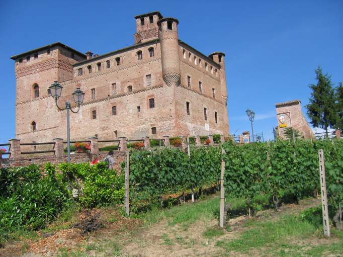
This landscape covers five distinct wine-growing areas with outstanding landscapes and the Castle of Cavour, an emblematic name both in the development of vineyards and in Italian history. It is located in the southern part of Piedmont, between the Po River and the Ligurian Apennines, and encompasses the whole range of technical and economic processes relating to the winegrowing and winemaking that has characterized the region for centuries. Vine pollen has been found in the area dating from the 5th century BC, when Piedmont was a place of contact and trade between the Etruscans and the Celts; Etruscan and Celtic words, particularly wine-related ones, are still found in the local dialect. During the Roman Empire, Pliny the Elder mentions the Piedmont region as being one of the most favourable for growing vines in ancient Italy; Strabo mentions its barrels.
UNESCO Justification of the World Heritage Site
Criterion (iii): The cultural landscapes of the Piedmont vineyards provide outstanding living testimony to winegrowing and winemaking traditions that stem from a long history, and that have been continuously improved and adapted up to the present day. They bear witness to an extremely comprehensive social, rural and urban realm, and to sustainable economic structures. They include a multitude of harmonious built elements that bear witness to its history and its professional practices.
Criterion (v): The vineyards of Langhe-Roero and Monferrato constitute an outstanding example of man’s interaction with his natural environment. Following a long and slow evolution of winegrowing expertise, the best possible adaptation of grape varieties to land with specific soil and climatic components has been carried out, which in itself is related to winemaking expertise, thereby becoming an international benchmark. The winegrowing landscape also expresses great aesthetic qualities, making it into an archetype of European vineyards.
Encyclopedia Record: Vineyard Landscape of Piedmont: Langhe-Roero and Monferrato
Vineyard Landscape of Piedmont: Langhe-Roero and Monferrato is the official name of a UNESCO World Heritage Site comprising "five distinct wine-growing areas with outstanding landscapes" plus the Castle of Grinzane Cavour in the region of Piedmont, Italy.Additional Site Details
Area: 10,789 hectares
Number of Components: 6
(v) — Outstanding example of traditional human settlement
Coordinates: 44.6086111111 , 7.9636111111
Image
© Cloud7, CC BY-SA 3.0 Resized from original. (This derivative is under the same CC BY-SA license.)
