World Heritage Identification Number: 1695
World Heritage since: 2023
Category: Cultural Heritage
WHE Type: Cultural Landscapes
Transboundary Heritage: No
Endangered Heritage: No
Country: 🇬🇷 Greece
Continent: Europe
UNESCO World Region: Europe and North America
Map
Exploring the Zagori Cultural Landscape: A Journey Through Time and Tradition
The Zagori Cultural Landscape, inscribed as a UNESCO World Heritage Site in 2023, offers a captivating glimpse into the rich cultural heritage of northwestern Greece. This remote rural landscape, nestled within the western slopes of the Pindus mountain range, is home to a unique collection of small stone villages known as Zagorochoria.
More to come…UNESCO Description of the World Heritage Site
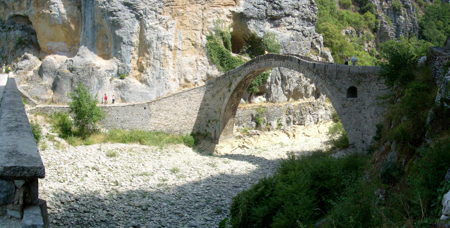
Located in a remote rural landscape in northwestern Greece, small stone villages known as Zagorochoria extend along the western slopes of the northern part of the Pindus mountain range. These traditional villages, typically organized around a central square containing a plane tree and surrounded by sacred forests maintained by local communities, showcase a traditional architecture adapted to the mountain topography. A network of stone-arched bridges, stone cobbled paths, and stone staircases linking the villages formed a system that served as a political and social unit connecting the communities of the Vikos and the Voïdomatis River basin.UNESCO Justification of the World Heritage Site
Criterion (v): Zagorochoria, the traditional villages of Zagori Cultural Landscape, are an outstanding example of traditional human settlements where the characteristics of the stonework showcased in traditional buildings, stone bridges, stone paths, and stone staircases represent a distinctive culture developed in a remote mountain region. The vernacular architecture, urban structure, and public infrastructure of the villages have been influenced by an exchange with other areas of the Balkans, Central Europe, Russia, Asia Minor, and Constantinople, where Zagorisians practiced temporary migration. Zagorisians imported ideas and styles to their homeland and provided investments which enabled the development of this isolated area of the Pindus Mountain range. Zagorochoria are representative of the common legacy of Byzantine and Ottoman vernacular architecture of the larger Balkan region, a style that has become rare, but is still reflected in the traditional stone architecture and traditional village layouts of Zagori. Zagorochoria are vulnerable to depopulation, while facing the challenge of preserving traditional forms of architecture and building practices whilst serving modern residential needs (water supply, drainage, vehicular access) as well as the eventual development of tourism.
Encyclopedia Record: Zagori
Zagori is a region, a municipality, and a designated UNESCO World Heritage Site, in the Pindus mountains in Epirus, in northwestern Greece. The seat of the municipality is the village Asprangeloi. It has an area of some 1,000 square kilometres (390 sq mi) and contains 46 villages known as Zagori villages, and is in the shape of an upturned equilateral triangle.Additional Site Details
Area: Not available
Number of Components: 1
Coordinates: 39.9052777778 , 20.8197222222