World Heritage Identification Number: 831
World Heritage since: 1997
Category: Cultural Heritage
WHE Type: Archaeological Sites
Transboundary Heritage: No
Endangered Heritage: No
Country: 🇮🇹 Italy
Continent: Europe
UNESCO World Region: Europe and North America
Map
The Archaeological Area of Agrigento: A Testament to Ancient Greek Civilization
The Archaeological Area of Agrigento, inscribed as a UNESCO World Heritage Site in 1997, stands as one of the most remarkable testimonies to the achievements of ancient Greek civilization in Sicily. Located on the southern coast of the island of Sicily, Italy, this extensive archaeological landscape preserves the remains of Akragas, one of the leading Greek cities of ancient Sicily and the western Mediterranean.
Founded around 580 BC by Greek settlers from Gela, Akragas quickly developed into a wealthy and powerful city. Its prosperity reached its height during the 5th century BC, particularly after the Greek victory over Carthage at the Battle of Himera in 480 BC, which brought wealth and political influence to the city. This prosperity enabled the construction of magnificent Doric temples along the ridge overlooking the surrounding countryside, with distant views towards the Mediterranean. Together with the remains of the ancient urban area, these monuments provide exceptional evidence of Greek architectural skill, religious practices, and city planning.
Among the most notable structures within the Archaeological Area of Agrigento is the Temple of Concordia, one of the best-preserved Doric temples in the ancient world. Dating from the 5th century BC, it has survived remarkably intact, preserving its elegant proportions and nearly complete colonnade. Another significant monument is the Temple of Herakles, one of the oldest temples in the area, whose surviving columns provide valuable insights into the development of early Greek monumental architecture.
Perhaps the most ambitious monument of ancient Akragas was the Temple of Olympian Zeus, begun after the Greek victory over Carthage at the Battle of Himera in 480 BC, probably to commemorate that victory and proclaim the city's power. Although now largely ruined, its enormous scale demonstrates the extraordinary ambitions of its builders and includes the remains of colossal stone figures known as telamons.
Beyond the impressive temples, the archaeological area preserves extensive traces of the ancient city, including defensive walls, sanctuaries, residential districts, burial areas, and hydraulic systems, including reservoirs, aqueducts, and underground waterworks, that reveal the complexity of urban life in Greek Sicily.
Despite its popular name, the "Valley of the Temples" (Valle dei Templi) is not actually situated in a valley but on a ridge south of modern Agrigento. This elevated position creates a dramatic setting in which the ancient temples appear against the Sicilian landscape, contributing to the site's exceptional visual and cultural significance.
The exceptional value of Agrigento lies not only in its individual monuments but also in the relationship between architecture, urban development, and the surrounding landscape. The temples were carefully positioned along the ridge to create a powerful visual connection between sacred spaces and the natural environment. Together, the monuments and archaeological remains provide one of the finest surviving archaeological landscapes of an ancient Greek city outside Greece and illustrate the enduring influence of Greek culture throughout the Mediterranean world.
The Archaeological Area of Agrigento represents an outstanding example of ancient Greek architecture and urban development, preserving one of the largest and most impressive collections of Doric temples outside Greece. Through the conservation of its monuments and archaeological remains, the site continues to offer invaluable insights into the beliefs, achievements, and daily life of the people who shaped this extraordinary center of the ancient Mediterranean world.
UNESCO Description of the World Heritage Site
Founded as a Greek colony in the 6th century B.C., Agrigento became one of the leading cities in the Mediterranean world. Its supremacy and pride are demonstrated by the remains of the magnificent Doric temples that dominate the ancient town, much of which still lies intact under today's fields and orchards. Selected excavated areas throw light on the later Hellenistic and Roman town and the burial practices of its early Christian inhabitants.
UNESCO Justification of the World Heritage Site
Criterion (i): The great row of Doric temples is one of the most outstanding monuments of Greek art and culture.
Criterion (ii): The archaeological area of Agrigento exhibits an important interchange of human values, being undoubtedly one of the leading cities in the Mediterranean region with its outstanding evidence of Greek influence.
Criterion (iii): As one of the greatest cities of the ancient Mediterranean region, Agrigento is an extraordinary testament of Greek civilization in its exceptionally preserved condition.
Criterion (iv): The temples in the area exemplify Greek architecture and are considered to be among the most extraordinary representations of Doric architecture in the world.
Encyclopedia Record: Valle dei Templi
The Valle dei Templi, or Valley of the Temples, is an archaeological site in Agrigento, Sicily. It is one of the most outstanding examples of ancient Greek art and architecture of Magna Graecia, and is one of the main attractions of Sicily. The term "valley" is a misnomer, the site being located on a ridge outside the town of Agrigento.Additional Site Details
Area: 934 hectares
Number of Components: 1
(ii) — Significant interchange of human values
(iii) — Unique or exceptional testimony to a cultural tradition
(iv) — Outstanding example of a type of building or landscape
Coordinates: 37.28972222 , 13.59333333
Image
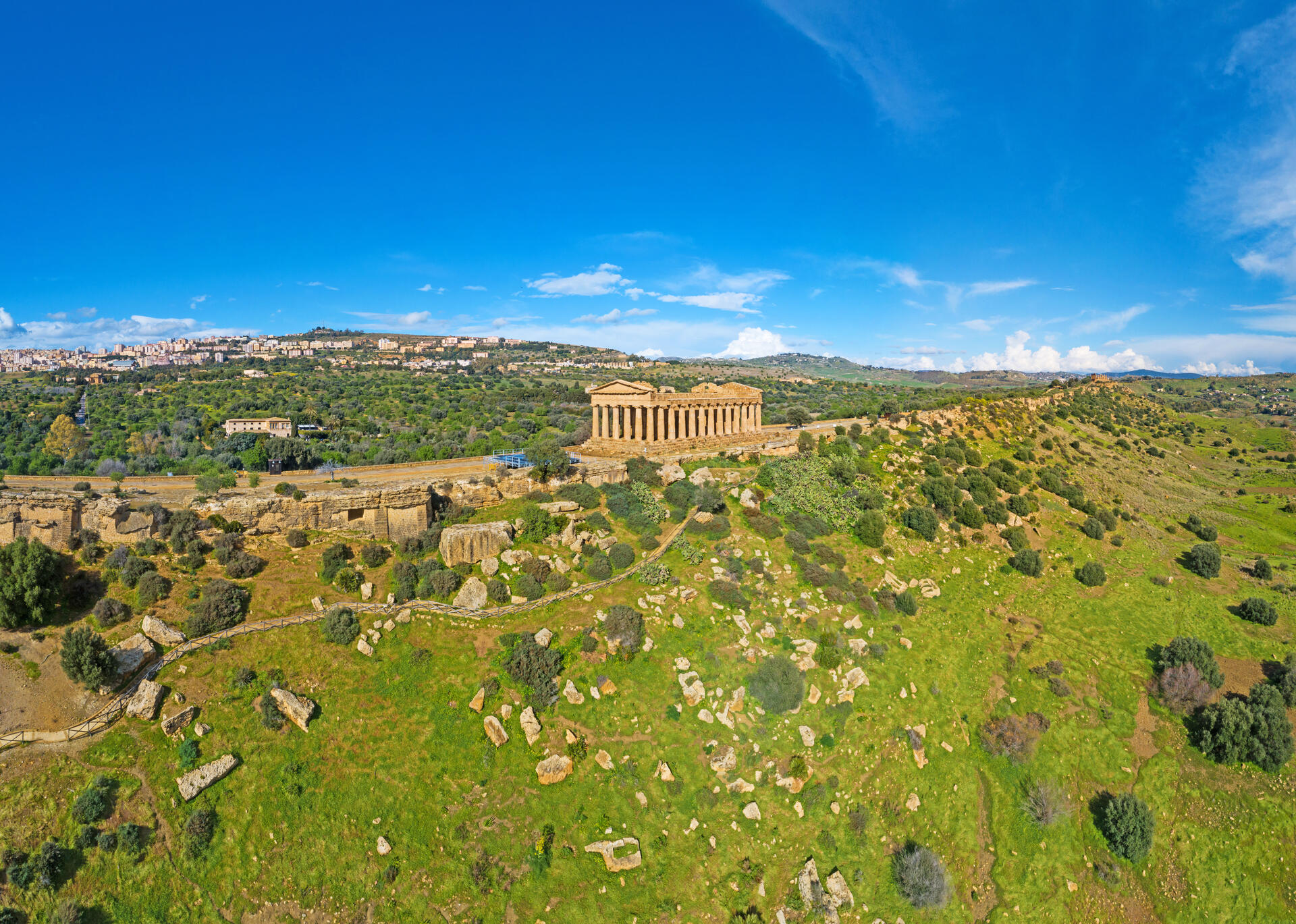
© Ludvig14, CC BY-SA 4.0 Resized from original. (This derivative is under the same CC BY-SA license.)
World Heritage Research
Discover scientific research and academic studies that deepen our understanding of Archaeological Area of Agrigento from its history and significance to its conservation, management, and contemporary challenges.
-
Continuity, Resilience, and Change in Rural Settlement Patterns from the Roman to Islamic Period in the Sicani Mountains (Central-Western Sicily)
A new study reveals how rural settlement patterns in the Sicani Mountains of central-western Sicily evolved from Roman to Islamic periods, highlighting dynamics of continuity, resilience, and change. Strategic location between Palermo and Agrigento played a pivotal role in communication networks across these eras. The research integrates archaeological fieldwork with GIS-based spatial and statistical analyses, incorporating topographic (elevation, slope, aspect, TPI, distance to water) and ecological factors (vegetation series). This approach elucidates the complex transition dynamics from Roman settlement systems to Islamic landscape formation, offering insights into the interplay between historical developments and environmental factors in shaping rural landscapes. The findings contribute significantly to understanding the long-term impacts of cultural and environmental changes on settlement patterns.
Castrorao Barba, A., Aleo Nero, C., Battaglia, G., Zambito, L., Virga, L., Messina, A., Cangemi, M., & Bazan, G. (2024). Continuity, Resilience, and Change in Rural Settlement Patterns from the Roman to Islamic Period in the Sicani Mountains (Central-Western Sicily). Land, 13(3), 400. https://doi.org/10.3390/land13030400
View Publication Record | Read Publication -
New discovery of an ancient building in Akragas (Valley of Temples, Agrigento, Italy) through the integration of geophysical surveys
A new discovery of buried building remains in the Valley of Temples, Agrigento (ancient Akragas), has been made using advanced geophysical surveys. The study, conducted over a 3,000 m² area north of Plateia I-L, employed non-invasive techniques such as Electromagnetic (EM) surveys and Electrical Resistivity Tomography (ERT). These methods revealed subsurface anomalies indicative of buried structures, which were later confirmed through archaeological excavations. A wall constructed with large calcarenite blocks was uncovered, suggesting the presence of a building from the Hellenistic or Classical period. This discovery is significant as it may represent part of a larger, more complex structure near the entrance of the 'circular altars' sanctuary, potentially playing a vital role in Akragas's religious topography.
Imposa, S., Grassi, S., Morreale, G., Pirrotta, C., Cavalier, L., Gilotti, A., Giuliano, D., Cayre, E., & Caliò, L. M. (2024). New discovery of an ancient building in Akragas (Valley of Temples, Agrigento, Italy) through the integration of geophysical surveys. Journal of Archaeological Science: Reports, 53, 104368. https://doi.org/10.1016/j.jasrep.2023.104368
View Publication Record | Read Publication -
New researches on Pottery workshops in Akragas. Excavations in the artisanal area outside Gate 5 (excavation 2019)
Recent excavations at the Archaeological Area of Agrigento have uncovered significant insights into the pottery production of ancient Akragas, particularly outside Gate 5. Researchers from the University of Bologna, in collaboration with the Archaeological and Landscape Park of the Valley of the Temples, identified two previously unknown kilns (D and E) within a sector of the city's kerameikos quarter. This area, located near the Hypsas river and the sanctuary dedicated to the Chtonian Deities, was known for its three kilns (A-C), but this study expanded the understanding of its craft activities. The workshop produced Greek-Western amphoras, banded pottery, plain ware, tiles, and terracotta figurines, offering a glimpse into the colony's dynamic production during a period of growth. Non-invasive surveys (2017-2018) and excavations (2019) were employed to systematically investigate this artisanal zone, providing valuable data on the organization and output of Akragas' pottery workshops.
Baldoni, V., & Scalici, M. (2019). New researches on Pottery workshops in Akragas. Excavations in the artisanal area outside Gate 5 (excavation 2019) [JB]. Ocnus. Quaderni della Scuola di Specializzazione in Beni Archeologici, 27, 107. https://doi.org/10.12876/OCNUS2706
View Publication Record | Read Publication -
3D Modeling of Two louteria Fragments by Image-Based Approach
A groundbreaking digital approach has successfully reconstructed and analyzed two small fragments of louteria, a large terracotta vase from the Greek colony of Akragas (modern-day Agrigento, Sicily). By employing high-precision 3D modeling techniques based on image analysis, researchers achieved unprecedented detail in documenting these archaeological artifacts. The resulting models revealed intricate decorative features and geometric characteristics that were previously obscured or challenging to study. This method not only preserves the fragments digitally but also provides a new framework for interpreting and understanding their historical significance within the UNESCO-listed Archaeological Area of Agrigento.
Ebolese, D., Lo Brutto, M., & Burgio, A. (2017). 3D MODELING OF TWO LOUTERIA FRAGMENTS BY IMAGE-BASED APPROACH. The International Archives of the Photogrammetry, Remote Sensing and Spatial Information Sciences, XLII-5/W1, 573–580. https://doi.org/10.5194/isprs-archives-xlii-5-w1-573-2017
View Publication Record | Read Publication -
A survey on the digital enhancement of the archaeological sites on Google and a multimedia pilot project in the Agrigento Valley of the Temples in Sicily (Italy)
A pioneering digital enhancement project at the UNESCO World Heritage Site, Agrigento Valley of the Temples, has successfully mapped the Temple of Juno Lacinia, making it the first Greek temple globally accessible via a 360° online tour on Google platforms. This initiative introduces interactive features such as clickable points of interest, accompanied by descriptive sheets detailing architectural and decorative elements, capitals, columns, 3D reconstructions, videos, and aerial virtual tours captured using drones. The project, currently in its pilot phase, aims to expand this immersive experience to the entire valley, offering multilingual (Italian and English) and audio-guided content. This approach not only preserves and showcases the site's cultural heritage but also sets a precedent for digital preservation and accessibility of archaeological sites worldwide.
Bonacini, E. (2017). A survey on the digital enhancement of the archaeological sites on Google and a multimedia pilot project in the Agrigento Valley of the Temples in Sicily (Italy). International Journal of Internet Technology and Secured Transactions, 7(1), 28. https://doi.org/10.1504/ijitst.2017.085733
View Publication Record | Read Publication -
Estrazione e raffinazione dello zolfo e paesaggio nella Sicilia romana tra IV e VI d.C.
Recent archaeological and historical evidence has redefined the chronology of sulphur extraction and refinement in the Agrigento region, Sicily, dating its peak activity between the late 4th and 6th centuries AD. This period saw significant sulphur production, primarily for agricultural use, particularly in viticulture to combat fungal diseases, which strengthened economic ties with Rome and other Mediterranean regions. The study highlights the transformation of mining landscapes during Late Antiquity and the Byzantine era, suggesting that Agrigento's role as a fiscal center may have diminished due to the rise of other centers. By analyzing historical sources like the Tabulae sulphuris and archaeological remains, researchers provide new insights into the commercial and cultural exchanges linked to Sicily's 'solfifera' area, emphasizing its broader significance in ancient trade networks.
Zambito, L. (2016). Estrazione e raffinazione dello zolfo e paesaggio nella Sicilia romana tra IV e VI d.C. Multi-, Inter- and Transdisciplinary Research in Landscape Archaeology. https://doi.org/10.5463/lac.2014.7
View Publication Record | Read Publication -
Towards a new definition of ancient Akragas' urban grid. Preliminary contribution for a new image of the city
A groundbreaking redefinition of ancient Akragas' urban grid challenges the long-standing 1958 model proposed by Griffo and Schmidt. Through collaborative research involving the Archaeological Park of Agrigento, Politecnico di Bari, University of Catania, and Kore University of Enna, scientists E. Brienza and M. Liuzzo analyzed ancient street patterns in the upper Agora, reconstructing the city's lost architectural landscape. This preliminary study introduces a novel planning scheme that significantly differs from previous interpretations, offering fresh insights into the spatial organization of this UNESCO-listed archaeological site.
Brienza, E., Caliò, L. M., & Liuzzo, M. (2016). Towards a new definition of ancient akragas’ urban grid. Preliminary contribution for a new image of the city [JD]. SCIRES-IT - SCIentific RESearch and Information Technology, 6(2). https://doi.org/10.2423/i22394303v6n2p49
View Publication Record | Read Publication -
Integration of constrained electrical and seismic tomographies to study the landslide affecting the cathedral of Agrigento
Integrated geophysical techniques reveal the complex subsurface structures underlying landslides at Agrigento's Cathedral of Saint Gerland, providing critical insights for stabilization efforts. The study combined 2D electrical resistivity tomography (ERT), seismic refraction tomography (SRT), microtremor analysis, and surface wave soundings to map lithological layers, fractures, and cavities affecting the hillside. By constraining geophysical data with stratigraphic information from boreholes, researchers constructed robust 3D models of electrical resistivity and P-wave velocity, elucidating the sliding processes that threaten the cathedral and adjacent Archaeological Park. These findings offer a foundation for targeted landslide consolidation works to preserve this UNESCO World Heritage Site.
Capizzi, P., & Martorana, R. (2014). Integration of constrained electrical and seismic tomographies to study the landslide affecting the cathedral of Agrigento. Journal of Geophysics and Engineering, 11(4). https://doi.org/10.1088/1742-2132/11/4/045009
View Publication Record | Read Publication