World Heritage Identification Number: 1336
World Heritage since: 2011
Category: Cultural Heritage
WHE Type: Archaeological Sites
Transboundary Heritage: No
Endangered Heritage: No
Country: 🇸🇩 Sudan
Continent: Africa
UNESCO World Region: Arab States
Map
Archaeological Sites of the Island of Meroe: A Window into Ancient African Civilization
The Archaeological Sites of the Island of Meroe, inscribed as a UNESCO World Heritage Site in 2011, offer a captivating glimpse into the rich history and cultural diversity of ancient Africa. Located in a semi-arid region between the Nile and Atbara rivers in present-day Sudan, these sites were once the heartland of the Kingdom of Kush, a significant power that spanned from the 8th century B.C. to the 4th century A.D.
More to come…UNESCO Description of the World Heritage Site
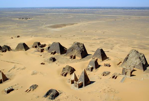
The Archaeological Sites of the Island of Meroe, a semi-desert landscape between the Nile and Atbara rivers, was the heartland of the Kingdom of Kush, a major power from the 8th century B.C. to the 4th century A.D. The property consists of the royal city of the Kushite kings at Meroe, near the River Nile, the nearby religious site of Naqa and Musawwarat es Sufra. It was the seat of the rulers who occupied Egypt for close to a century and features, among other vestiges, pyramids, temples and domestic buildings as well as major installations connected to water management. Their vast empire extended from the Mediterranean to the heart of Africa, and the property testifies to the exchange between the art, architectures, religions and languages of both regions.
UNESCO Justification of the World Heritage Site
Criterion (ii): The Archaeological Sites of the Island of Meroe reflect the interchange of ideas and contact between Sub-Saharan Africa and the Mediterranean and Middle Eastern worlds, along a major trade corridor over a very long period of time. The interaction of local and foreign influences is demonstrated by the preserved architectural remains and their iconography.
Criterion (iii): The property with its wide range of monument types, well preserved buildings, and potential for future excavation and research, contributes an exceptional testimony to the wealth and power of the former Kushite state and its extensive contacts with African, Mediterranean and Middle Eastern societies. The Kushite civilization was largely expunged by the arrival of Christianity on the Middle Nile in the 6th century CE.
Criterion (iv): The pyramids at Meroe are outstanding examples of Kushite funerary monuments, which illustrate the association with the well preserved remains of the urban centre of the Kushite capital city, Meroe. The architectural remains at the three site components illustrate the juxtaposition of structural and decorative elements from Pharaonic Egypt, Greece, and Rome as well as from Kush itself, and through this represent a significant reference of early exchange and diffusion of styles and technologies.
Criterion (v): The major centres of human activity far from the Nile at Musawwarat and Naqa raise questions as to their viability in what is today an arid zone devoid of permanent human settlement. They offer the possibility, through a detailed study of the palaeoclimate, flora, and fauna, of understanding the interaction of the Kushites with their desert hinterland.
Encyclopedia Record: Meroë
Meroë was an ancient city on the east bank of the Nile about 6 km north-east of the Kabushiya station near Shendi, Sudan, approximately 200 km north-east of Khartoum. Near the site is a group of villages called Bagrawiyah. This city was the capital of the Kingdom of Kush for several centuries from around 590 BC, until its collapse in the 4th century AD. The Kushitic Kingdom of Meroë gave its name to the "Island of Meroë", which was the modern region of Butana, a region bounded by the Nile, the Atbarah and the Blue Nile.Additional Site Details
Area: 2,357.36 hectares
Number of Components: 4
(iii) — Unique or exceptional testimony to a cultural tradition
(iv) — Outstanding example of a type of building or landscape
(v) — Outstanding example of traditional human settlement
Coordinates: 16.9333333333 , 33.7166666667
Image
© Photographer: B N Chagny, CC BY-SA 1.0 Resized from original. (This derivative is under the same CC BY-SA license.)
