
World Heritage Identification Number: 1638
World Heritage since: 2024
Category: Natural Heritage
WHE Type: Natural Landscapes & Geographic Features
Transboundary Heritage: No
Endangered Heritage: No
Country: 🇨🇳 China
Continent: Asia
UNESCO World Region: Asia and the Pacific
Map
Exploring the Badain Jaran Desert: A Unique Landscape of Sand Towers and Interdunal Lakes
The Badain Jaran Desert, located in the Alashan Plateau of northwestern China, is a remarkable example of a hyper-arid desert landscape that showcases a unique combination of towering sand dunes, interdunal lakes, and diverse habitats. Inscribed as a UNESCO World Heritage Site in 2024, this vast desert spanning over 49,000 square kilometers across the provinces of Gansu, Ningxia, and Inner Mongolia, is the third largest desert in China.
More to come…UNESCO Description of the World Heritage Site
Located in the Alashan Plateau in the hyper-arid and temperate desert region of northwestern China, the Badain Jaran Desert is a meeting point for three sandy regions of China and is the country’s third largest desert and second largest drifting desert. The property stands out with its high density of mega-dunes, intersected with inter-dunal lakes. It displays spectacular ongoing geological and geomorphic features of desert landscapes and landforms which may well be unparalleled. Noteworthy features, among others, include the world’s tallest, stabilized sand mega-dune (relative relief of 460 m); the highest concentration of inter-dunal lakes; and the largest expanse of so-called singing sands (describing the resonance caused for example by wind moving dry and loose sand) and wind-eroded landforms. The varied landscape also results in a high level of habitat diversity, and hence of biodiversity.
UNESCO Justification of the World Heritage Site
Criterion (vii): Badain Jaran Desert - Towers of Sand and Lakes display spectacular ongoing geological and geomorphic features of desert landscapes and landforms subject to a temperate, hyper-arid climate. These features create exceptional aesthetic values emerging from the dense range of stabilized, linear, and parallel mega-dunes with numerous inter-dunal lakes as well as various types of smaller dunes in-between the mega-dunes. 144 inter-dunal lakes exhibit a myriad of colours, caused by different levels of salinity and microbial communities. With an exceptional expanse of so-called singing sands (describing the resonance caused e.g. by wind moving dry and loose sand), the property also presents a remarkable soundscape. Wind-eroded landforms, oases, ripple effects and the grandeur of the world’s tallest sand mega-dunes (relative relief of 460 m) compose a landscape of remarkable natural beauty. The dynamic of shifting sand dunes creates an ever-changing visual environment.
Criterion (viii): The property is located at the junction of three sandy regions of China and provides an outstanding example of the ongoing evolution of desert landscapes and landforms under a temperate and hyper-arid climate. It records and displays an exceptional variety of aeolian features and desert geomorphology, such as linear and parallel, stabilized mega-dunes and associated inter-dunal lakes. The property appears to be a very rare example at global scale that reflects the evolutionary landforms as a combined result of regional tectonism and hydrogeological changes associated with climatic evolution. The property also stands out due to the remarkable stability of its linear mega-dunes and the abundance of inter-dunal lakes. It boasts the densest collection of stabilized mega-dunes globally, encompassing among the tallest sand dunes and the highest concentration of inter-dunal lakes found anywhere on Earth. With 144 inter-dunal lakes and the considerable variety of dune formations, the property hosts a remarkable geodiversity. Both IUCN’s 2011 thematic study on desert landscapes and IUCN’s 2021 study on the application of criterion (viii) highlighted the property as one of the most significant desert landscapes and geomorphological sites, not currently represented on the World Heritage List.
Encyclopedia Record: Badain Jaran Desert
The Badain Jaran Desert is a desert in China which spans the provinces of Gansu, Ningxia and Inner Mongolia. It covers an area of 49,000 square kilometers. By size it is the third largest desert in China.Additional Site Details
Area: 726,291.4 hectares
Number of Components: 1
(viii) — Outstanding example representing major earth stages
Coordinates: 39.8897222222 , 102.2894444444
IUCN World Heritage Outlook
The 2025 Conservation Outlook on Badain Jaran Desert - Towers of Sand and Lakes reports the following assessment:
Source: International Union for Conservation of Nature (IUCN) · View assessment
Image
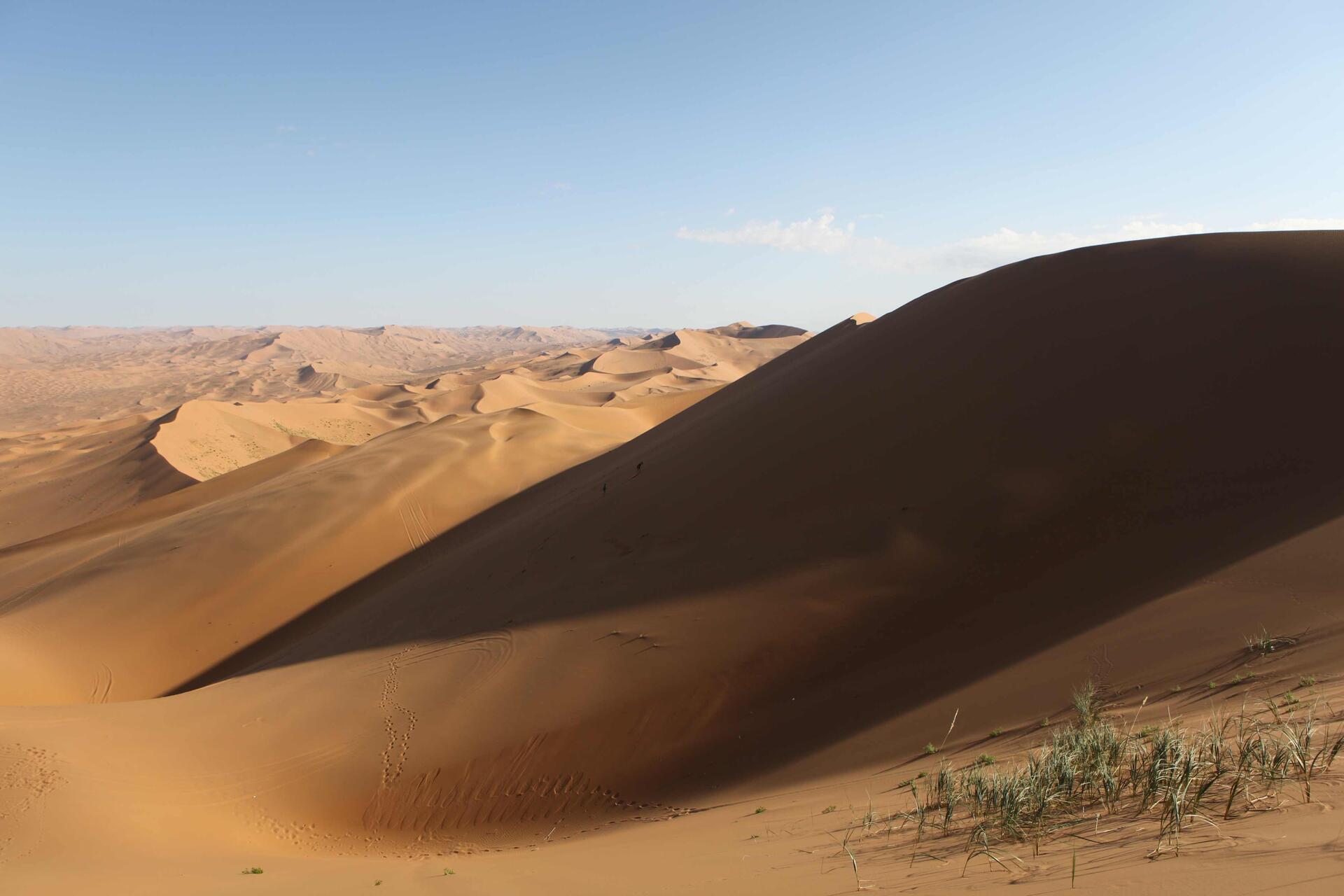
© Sjoerd van Oort, CC BY-SA 3.0 Resized from original. (This derivative is under the same CC BY-SA license.)

World Heritage Research
Discover scientific research and academic studies that deepen our understanding of Badain Jaran Desert - Towers of Sand and Lakes from its history and significance to its conservation, management, and contemporary challenges.
-
Ecosystem health assessment of desert nature reserve with entropy weight and fuzzy mathematics methods: A case study of Badain Jaran Desert
A comprehensive ecosystem health assessment of the Badain Jaran Desert, the fourth largest desert globally, reveals that 68.1% of its area is in healthy or sub-healthy status, with only 4% and 0.2% classified as unhealthy and sick, respectively. The study utilized entropy weight and fuzzy mathematics methods to evaluate 11 key indicators—such as biomass, net primary productivity (NPP), and soil parameters—across the desert's spatial scale. Findings indicate that while the interior of the desert maintains ecological stability, peripheral areas with frequent human activity require urgent protection and restoration to mitigate further degradation. This research establishes a technical framework for ecosystem health assessment in arid desert reserves, offering critical support for monitoring, prevention, and sustainable management.
Cheng, W., Xi, H., Sindikubwabo, C., Si, J., Zhao, C., Yu, T., Li, A., & Wu, T. (2020). Ecosystem health assessment of desert nature reserve with entropy weight and fuzzy mathematics methods: A case study of Badain Jaran Desert. Ecological Indicators, 119, 106843. https://doi.org/10.1016/j.ecolind.2020.106843
View Publication Record | Read Publication -
Origin of water in the Badain Jaran Desert, China: new insight from isotopes
New isotopic evidence challenges long-standing hypotheses about the origin of water in China's Badain Jaran Desert, revealing that both groundwater and lake water are sourced from modern precipitation in the region rather than remote or ancient sources. The study analyzed radiocarbon (14C), tritium (3H), stable hydrogen and oxygen isotopes (δ2H – δ18O), and d-excess values in water samples from lakes, springs, and local aquifers, alongside evaporation experiments to assess isotopic changes under desert conditions. Contrary to previous theories, the data show that groundwater is derived from recent meteoric precipitation, not ancient carbonates or early Holocene recharge, debunking claims of distant Tibetan Plateau or paleoclimate origins.
Wu, X., Wang, X.-S., Wang, Y., & Hu, B. X. (2017). Origin of water in the Badain Jaran Desert, China: new insight from isotopes. Hydrology and Earth System Sciences, 21(9), 4419–4431. https://doi.org/10.5194/hess-21-4419-2017
View Publication Record | Read Publication -
Satellite-based estimates of groundwater depletion in the Badain Jaran Desert, China
Groundwater depletion is accelerating in the Badain Jaran Desert, China, despite some recent increases in soil water due to climate-driven rainfall. A study using satellite altimetry and hydrological models found that lake levels and groundwater storage have declined significantly from 2003 to 2009, with long-term depletion outpacing short-term gains. If unchecked, this trend threatens the survival of fragile desert oases, posing ecological and environmental risks.
Jiao, J. J., Zhang, X., & Wang, X. (2015). Satellite-based estimates of groundwater depletion in the Badain Jaran Desert, China. Scientific Reports, 5(1). https://doi.org/10.1038/srep08960
View Publication Record | Read Publication -
Hydrochemical characteristics and recharge sources of Lake Nuoertu in the Badain Jaran Desert
Lake Nuoertu, one of the largest and deepest lakes in the Badain Jaran Desert, exhibits significant annual and seasonal variations in its physical and chemical characteristics, unlike groundwater. The lake's hydrochemical composition is consistently Na-Cl-CO3-(SO4), indicating strong evaporation in the region. Stable isotope analysis reveals that groundwater serves as the primary recharge source for Lake Nuoertu, with evidence suggesting a mixed origin of modern and older water (pre-1952). Tritium dating of tufa springs around the lake estimates their age at 75–80 years, highlighting the complex recharge dynamics. The study utilized ion concentrations, total dissolved solids, stable isotopes, and tritium analysis to unravel these processes.
Wu, Y., Wang, N., Zhao, L., Zhang, Z., Chen, L., Lu, Y., Lü, X., & Chang, J. (2014). Hydrochemical characteristics and recharge sources of Lake Nuoertu in the Badain Jaran Desert. Chinese Science Bulletin, 59(9), 886–895. https://doi.org/10.1007/s11434-013-0102-8
View Publication Record | Read Publication -
Observation of mega-dune evaporation after various rain events in the hinterland of Badain Jaran Desert, China
Local atmospheric precipitation does not significantly contribute to recharging the groundwater system in the hinterland of Badain Jaran Desert, China. This conclusion was drawn from a study analyzing evaporation on mega-dune surfaces following various rain events, categorized into conventional precipitation (CP), ordinary annual maximum (OAM), and extreme precipitation (EP). The research used long-term precipitation records, automatic weather station data, and eddy covariance system measurements to assess evaporation patterns. Results showed that CP and OAM evaporated within 1-3 days and 3-4 weeks, respectively, while EP required a prolonged period due to the upper dry sand layer's influence. These findings provide insight into the formation mechanisms of lakes in this unique desert region.
Ma, N., Wang, N., Zhao, L., Zhang, Z., Dong, C., & Shen, S. (2013). Observation of mega-dune evaporation after various rain events in the hinterland of Badain Jaran Desert, China. Chinese Science Bulletin, 59(2), 162–170. https://doi.org/10.1007/s11434-013-0050-3
View Publication Record | Read Publication -
Origins of Groundwater Inferred from Isotopic Patterns of the Badain Jaran Desert, Northwestern China
Groundwater in the Badain Jaran Desert (BJD) originates from ancient climatic conditions with higher humidity and lower temperatures, distinct from modern precipitation. Isotopic analysis of δ D, δ 18 O, and d-excess reveals strong evaporation effects and no hydraulic connection to distant regions except Outer Mongolia. The study found that BJD groundwater has abnormally negative d-excess values (-17.5‰), differing significantly from local precipitation (5.7‰) and nearby water bodies, indicating limited modern recharge. Research involved comparing isotopic patterns across the BJD, Heihe River Basin, and surrounding areas to reconstruct past climatic conditions.
Zhao, L., Xiao, H., Dong, Z., Xiao, S., Zhou, M., Cheng, G., Yin, L., & Yin, Z. (2011). Origins of Groundwater Inferred from Isotopic Patterns of the Badain Jaran Desert, Northwestern China. Groundwater, 50(5), 715–725. Portico. https://doi.org/10.1111/j.1745-6584.2011.00895.x
View Publication Record | Read Publication