World Heritage Identification Number: 848
World Heritage since: 1998
Category: Cultural Heritage
WHE Type: Archaeological Sites
Transboundary Heritage: No
Endangered Heritage: No
Country: 🇨🇾 Cyprus
Continent: Asia
UNESCO World Region: Europe and North America
Map
Choirokoitia: A Prehistoric Gem in the Eastern Mediterranean
Choirokoitia, located on the island of Cyprus, stands as a testament to the rich history and cultural development of the eastern Mediterranean during the Neolithic age. This remarkable archaeological site, inscribed as a UNESCO World Heritage Site in 1998, offers valuable insights into the evolution of human societies in this pivotal region.
More to come…UNESCO Description of the World Heritage Site
The Neolithic settlement of Choirokoitia, occupied from the 7th to the 4th millennium B.C., is one of the most important prehistoric sites in the eastern Mediterranean. Its remains and the finds from the excavations there have thrown much light on the evolution of human society in this key region. Since only part of the site has been excavated, it forms an exceptional archaeological reserve for future study.
UNESCO Justification of the World Heritage Site
Criterion (ii): In the prehistoric period, Cyprus played a key role in the transmission of culture from the Near East to the European world.
Criterion (iii): Choirokoitia is an exceptionally well-preserved archaeological site that has provided, and will continue to provide, scientific data of great importance relating to the spread of civilization from Asia to the Mediterranean world.
Criterion (iv): Both the excavated remains and the untouched part of Choirokoitia demonstrate clearly the origins of proto-urban settlement in the Mediterranean region and beyond.
Encyclopedia Record: Khirokitia
Khirokitia is an archaeological site on the island of Cyprus dating from the Neolithic age. It has been listed as a World Heritage Site by UNESCO since 1998. The site is known as one of the most important and best preserved prehistoric sites of the eastern Mediterranean. Much of its importance lies in the evidence of an organised functional society in the form of a collective settlement, with surrounding fortifications for communal protection. The Neolithic aceramic period is represented by this settlement and around 20 other similar settlements spread throughout the island.Additional Site Details
Area: 6.2 hectares
Number of Components: 1
(iii) — Unique or exceptional testimony to a cultural tradition
(iv) — Outstanding example of a type of building or landscape
Coordinates: 34.7967406661 , 33.3439431453
Image
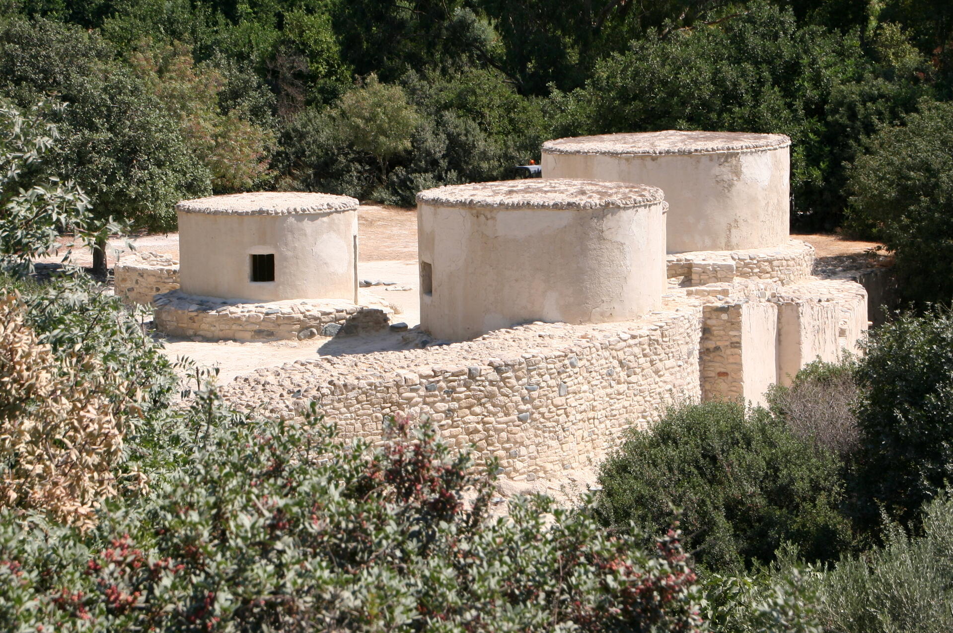
© Ophelia2, CC BY-SA 3.0 Resized from original. (This derivative is under the same CC BY-SA license.)
World Heritage Research
Discover scientific research and academic studies that deepen our understanding of Choirokoitia from its history and significance to its conservation, management, and contemporary challenges.
-
Designing and Evaluating a Game-Based AR Application for Heritage Learning: Insights from the Choirokoitia Mystery Game
A game-based Augmented Reality (AR) application designed for heritage learning at the Neolithic site of Choirokoitia demonstrates significant pedagogical and technological potential. This study, rooted in design-based research (DBR) and multimodal theory, reveals how iterative processes can effectively integrate AR into culturally rich educational contexts. The research highlights six key phases, from aligning scenario design with project requirements to identifying future directions, showcasing the complexities and affordances of AR for exploration and collaboration. Task-oriented activities were central to the pedagogical approach, emphasizing the importance of multimodal contexts in enhancing learning experiences within higher education settings.
Hadjistassou, S., Joannidou, S., J. Molina Muñoz , P., Louca, P., & Ellinas, G. (2026). Designing and Evaluating a Game-Based AR Application for Heritage Learning: Insights from the Choirokoitia Mystery Game. Journal of Learning for Development, 13(1), 147–161. https://doi.org/10.56059/jl4d.v13i1.1585
View Publication Record | Read Publication -
Khirokitia, an idiosyncratic Neolithic settlement in Cyprus, its putative foreign relations, and integrity in archaeological research
A groundstone artifact claimed by archaeologist James Mellaart to have originated from the northern Levant and been found at the Neolithic site of Khirokitia in Cyprus was determined to never have existed. The study, which scrutinized Mellaart's archaeological records from the 1960s–70s alongside recent research, found no citation or physical evidence supporting the claim. This case is part of a broader pattern of suspect claims by Mellaart over six decades, highlighting the serious academic consequences of fabricating ancient material culture. The research underscores the need for greater attention to integrity in archaeological studies.
Edwards, P. C. (2026). Khirokitia, an idiosyncratic Neolithic settlement in Cyprus, its putative foreign relations, and integrity in archaeological research. Buried History: The Journal of the Australian Institute of Archaeology, 61, 17–32. https://doi.org/10.62614/8nf1mq76
View Publication Record | Read Publication -
Monitoring Climate Change in Cultural Heritage Sites Through Enhanced Visualisation Experiences and Crowdsourcing
Climate change poses significant threats to cultural heritage sites, necessitating innovative risk assessment and mitigation strategies. The TRIQUETRA project addresses this challenge by integrating advanced technologies such as remote sensing, laser-based spectroscopy, and crowdsourcing to monitor climate risks at UNESCO World Heritage Sites like Choirokoitia in Cyprus. This approach quantifies the severity of hazards, tracks their progression, and informs adaptive preservation measures. By leveraging a dynamic web and mobile platform, TRIQUETRA engages citizens and visitors to contribute real-time data through photo uploads, enhancing 3D models and providing stakeholders with actionable insights. Additionally, immersive Virtual Reality (VR) and Augmented Reality (AR) experiences enrich visitor engagement while raising awareness about climate-induced vulnerabilities. The project establishes a scalable framework that combines technological innovation with community participation to safeguard cultural heritage globally.
Themistocleous, K., Evripidou, V., & Toumbas, K. (2025). Monitoring Climate Change in Cultural Heritage Sites Through Enhanced Visualisation Experiences and Crowdsourcing https://doi.org/10.5194/egusphere-egu25-12307
View Publication Record | Read Publication -
Le Brun A. (dir.) 2021 – Fouilles récentes à Khirokitia (Chypre) 1993-2009, Nicosie, Département des Antiquités, Chypre, 444 p. Par Maxence Bailly
Recent excavations at Choirokoitia, Cyprus, have significantly advanced our understanding of Neolithic architecture in the Eastern Mediterranean. The site's unique domestic structures, characterized by multi-room houses with central courtyards, offer unprecedented insights into early settlement patterns and social organization. Maxence Bailly's analysis of findings from 1993 to 2009 builds upon earlier research, providing a comprehensive documentation that challenges conventional narratives about Neolithic development in the region. The study employs a meticulous archaeological approach, combining stratigraphic analysis with artifact studies to reconstruct daily life and cultural practices during this pivotal period.
Bailly, M. (2025). Le Brun A. (dir.) 2021 – Fouilles récentes à Khirokitia (Chypre) 1993-2009, Nicosie, Département des Antiquités, Chypre, 444 p. Par Maxence Bailly. Paléorient, 50, 177–179. https://doi.org/10.4000/145z8
View Publication Record | Read Publication -
Monitoring cultural heritage sites at risk using citizen engagement through crowdsourcing
Climate change poses significant risks to cultural heritage sites, threatening their physical integrity and the socio-economic systems they support. The TRIQUETRA project addresses these challenges by integrating advanced technologies like remote sensing and laser-based spectroscopy with citizen engagement through crowdsourcing. This innovative approach enables visitors to actively participate in monitoring by capturing and uploading site photos, which complement existing 3D models and provide up-to-date imagery for authorities. The project also incorporates augmented reality (AR) experiences to raise awareness about at-risk features and structural vulnerabilities. Applied to the UNESCO World Heritage Site of Choirokoitia in Cyprus, TRIQUETRA offers a replicable framework that enhances risk assessment and promotes active preservation efforts, benefiting cultural heritage sites globally.
Themistocleous, K., Evripidou, V., & Toumbas, K. (2025). Monitoring cultural heritage sites at risk using citizen engagement through crowdsourcing. The International Archives of the Photogrammetry, Remote Sensing and Spatial Information Sciences, XLVIII-G-2025, 1435–1440. https://doi.org/10.5194/isprs-archives-xlviii-g-2025-1435-2025
View Publication Record | Read Publication -
The Use of Digital Twins for the Management of Cultural Heritage Sites
Digital twins emerge as powerful tools for managing UNESCO World Heritage Sites, particularly those vulnerable to natural hazards. A study highlights their potential in monitoring and mitigating risks like rockfall at Choirokoitia, a well-preserved Neolithic site in Cyprus. Using 3D volumetric models and augmented reality (AR) applications, the EXCELSIOR and TRIQUETRA projects demonstrate how digital twins can dynamically visualize sites, track changes from climate-induced stress, and enhance visitor experiences. The research also assesses long-term risks posed by extreme weather and seasonal variations, offering a proactive approach to preserving cultural heritage. This method combines state-of-the-art techniques with practical applications, setting a precedent for safeguarding vulnerable archaeological sites.
Themistocleous, K., & Abate, D. (2025). The Use of Digital Twins for the Management of Cultural Heritage Sites. https://doi.org/10.5194/egusphere-egu24-20549
View Publication Record | Read Publication -
The Triquetra Knowledge Base Platform
A digital innovation, the TRIQUETRA Knowledge Base Platform (KBP), has been developed to serve as a comprehensive electronic repository for cultural heritage data. This platform integrates advanced search tools and WebGIS capabilities, enabling efficient discovery of information related to multiple UNESCO World Heritage Sites, including Choirokoitia. The KBP's architecture supports diverse datasets, from literature reviews to geospatial data, with potential for future expansion beyond its initial scope. By leveraging a robust technological stack, the platform demonstrates how integrated systems can enhance accessibility and analysis of cultural heritage information.
Anastasiou, A., Magkoufis, E., Kontopoulos, C., & Charalampopoulou, V. B. (2024). The Triquetra Knowledge Base Platform. IGARSS 2024 - 2024 IEEE International Geoscience and Remote Sensing Symposium, 3356–3360. https://doi.org/10.1109/igarss53475.2024.10642434
View Publication Record | Read Publication