World Heritage Identification Number: 820
World Heritage since: 1997
Category: Natural Heritage
WHE Type: Protected Areas & National Parks
Transboundary Heritage: No
Endangered Heritage: No
Country: 🇨🇷 Costa Rica
Continent: Americas
UNESCO World Region: Latin America and the Caribbean
Map
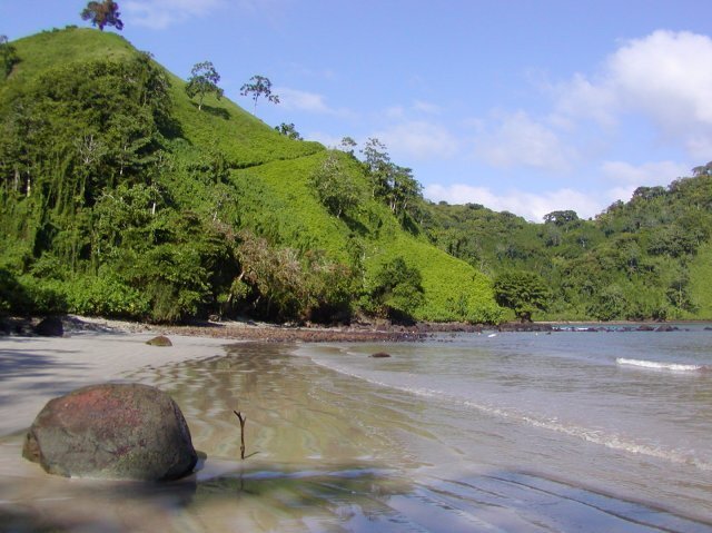
Cocos Island National Park: A Biodiversity Hotspot in the Eastern Pacific
Cocos Island National Park, located approximately 550 kilometers off the Pacific coast of Costa Rica, is a unique and captivating destination that offers an extraordinary blend of terrestrial and marine biodiversity. This remote island, which is the only island in the tropical eastern Pacific with a tropical rainforest, was inscribed as a UNESCO World Heritage Site in 1997.
More to come…UNESCO Description of the World Heritage Site
Cocos Island National Park, located 550 km off the Pacific coast of Costa Rica, is the only island in the tropical eastern Pacific with a tropical rainforest. Its position as the first point of contact with the northern equatorial counter-current, and the myriad interactions between the island and the surrounding marine ecosystem, make the area an ideal laboratory for the study of biological processes. The underwater world of the national park has become famous due to the attraction it holds for divers, who rate it as one of the best places in the world to view large pelagic species such as sharks, rays, tuna and dolphins.
UNESCO Justification of the World Heritage Site
Criterion (ix): The property harbours a rare and complex mosaic of land and sea environments, including forested mountains, rivers, waterfalls, estuaries, cliffs, sandy and rocky beaches, bays, and extensive and highly diverse coral reefs and pelagic environments. The oceanic island, more than 500 kilometers off the continent, is mostly occupied by tropical rainforest and, from around 500 m.a.s.l. to the highest elevation at 634 m.a.s.l., by cloud forest. The isolation has been allowing ongoing evolutionary processes on land, giving origin to countless endemic species in the most diverse taxonomic groups, including several vertebrate species. The geographic location at the meeting point of the North Equatorial Countercurrent with other major marine currents and the ecological interactions between a remote island and the surrounding marine ecosystems are of major scientific importance. The currents and the island affect the movements and distribution of the many migratory marine species aggregating for feeding and reproduction in the waters around the island. The property serves as a dispersion centre of larvae of numerous marine species coming from the entire Pacific. The islets and rocks around the main island are reported to also serve as important cleaning stations, i.e. pelagic species aggregate to have parasites removed by specialised fish and other species.
Criterion (x): The small island supports the only tropical forest ecosystem located on an oceanic island within the Tropical Eastern Pacific. It is home to some 70 endemic species of vascular plants and several endemic animals, including three birds, two reptiles and even two freshwater fish. Smaller satellite rocks around the island support nesting and resting habitats for numerous migratory and resident bird species. However, the main species conservation value derives from critical marine habitat and the corresponding role of the property in the conservation of large pelagic species, especially several species of sharks. Among the latter are exceptional aggregations of the near-threatened Silky and Lemon Shark, the vulnerable Bigeye Thresher Shark and Galapagos Shark, the emblematic and endangered Hammerhead Shark, as well as White-tip Reef Shark and Black-tip Shark. Among some 300 recorded fish species are important aggregations of large pelagic fish, such as the vulnerable Whale Shark and Blue Marlin, as well as Sailfish Broadbill Swordfish, Shortbill Spearfish, Giant Manta Ray and Pelagic Stingray. Blue Whale and Bottlenose Dolphin are among the visiting marine mammals.
Encyclopedia Record: Cocos Island
Cocos Island is a volcanic island in the Pacific Ocean administered by Costa Rica, approximately 550 km southwest of the Costa Rican mainland. It constitutes the 11th of the 15 districts of Puntarenas Canton of the Province of Puntarenas. With an area of approximately 23.85 km2 (9.21 sq mi), the island is roughly rectangular in shape. It is the southernmost point of geopolitical North America if non-continental islands are included, and the only landmass above water on the Cocos tectonic plate.Additional Site Details
Area: 199,700 hectares
Number of Components: 1
(x) — Contains most important habitats for biodiversity
Coordinates: 5.533333333 , -87.06666667
IUCN World Heritage Outlook
The 2025 Conservation Outlook on Cocos Island National Park reports the following assessment:
Source: International Union for Conservation of Nature (IUCN) · View assessment