World Heritage Identification Number: 1216
World Heritage since: 2006
Category: Natural Heritage
WHE Type: Protected Areas & National Parks
Transboundary Heritage: No
Endangered Heritage: No
Country: 🇨🇴 Colombia
Continent: Americas
UNESCO World Region: Latin America and the Caribbean
Map
Malpelo Fauna and Flora Sanctuary: A Marine Biodiversity Haven
The Malpelo Fauna and Flora Sanctuary, inscribed as a UNESCO World Heritage Site in 2006, is a significant marine protected area located approximately 506 kilometers off the coast of Colombia. Encompassing Malpelo Island and its surrounding marine environment spanning 857,150 hectares, this sanctuary serves as a vital habitat for numerous globally threatened marine species and boasts one of the most diverse marine ecosystems in the Eastern Tropical Pacific.
More to come…UNESCO Description of the World Heritage Site
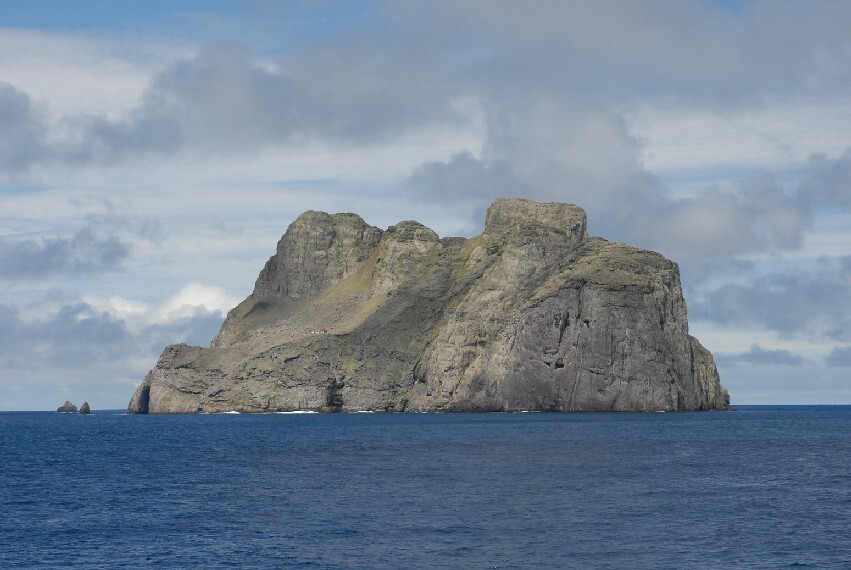
Located some 506 km off the coast of Colombia, the site includes Malpelo island (350 ha) and the surrounding marine environment (857,150 ha). This vast marine park, the largest no-fishing zone in the Eastern Tropical Pacific, provides a critical habitat for internationally threatened marine species, and is a major source of nutrients resulting in large aggregations of marine biodiversity. It is in particular a ‘reservoir' for sharks, giant grouper and billfish and is one of the few places in the world where sightings of the short-nosed ragged-toothed shark, a deepwater shark, have been confirmed. Widely recognized as one of the top diving sites in the world, due to the presence of steep walls and caves of outstanding natural beauty, these deep waters support important populations of large predators and pelagic species (e.g. aggregations of over 200 hammerhead sharks and over 1,000 silky sharks, whale sharks and tuna have been recorded) in an undisturbed environment where they maintain natural behavioural patterns.
UNESCO Justification of the World Heritage Site
Criterion (vii): The pristine underwater environment of Malpelo Fauna and Flora Sanctuary featuring dramatic cliffs, rock formations, caves and tunnels, as well as abundant and diverse marine life is of striking natural beauty. The major aggregations of the full range of large top predators are an increasingly rare sight in the World's overfished seas. The geographically extraordinary position at the meeting point of several marine currents, the varied underwater mountain seascape and the excellent state of conservation combine to make the property a World Class ocean oasis – and an exhilarating experience for divers.
Criterion (ix): Due to its remote location and as the largest no-fishing zone in the Eastern Tropical Pacific, Malpelo Fauna and Flora Sanctuary supports unaltered ecosystems free of major acute threats. The confluence of several marine currents turns the property into an unusual geographical spot with a complex and diverse array of habitats and species. The three major marine communities surrounding Malpelo Island can be distinguished as belonging to the vertical habitats, the coral reefs and the pelagic. Large top predators continue to fulfil their ecological roles and behaviour patterns continue undisturbed, providing unique opportunities for research. The evolutionary processes associated with the extreme isolation, the convergence of several ocean currents and related nutrient regimes and the geological formations are of great ecological importance and scientific interest. Free of alien invasive species, Malpelo Island and the surrounding waters are not only a conservation gem on its own but contribute to the maintenance, dispersal and replenishment of benthic larvae of corals, fish and mollusks and other marine life in the broader Eastern Tropical Pacific. As the wider region is under increasing pressure from overfishing and other threats, the property is thus of enormous conservation and indeed economic importance well beyond its boundaries.
Encyclopedia Record: Malpelo Island
Malpelo is an oceanic island in the eastern Pacific Ocean, about 500 km (310 mi) west of the Colombian mainland with a military post defended by the Colombian Armed Forces. It consists of a sheer and barren rock with three high peaks, the highest being the 300 m (980 ft) Cerro de la Mona. The island is about 1.5 kilometres in length from northeast to southwest, and 640 metres across at its widest.Additional Site Details
Area: 857,500 hectares
Number of Components: 1
(ix) — Outstanding example representing ecological and biological processes
Coordinates: 4.003344 , -81.607572
IUCN World Heritage Outlook
The 2025 Conservation Outlook on Malpelo Fauna and Flora Sanctuary reports the following assessment:
Source: International Union for Conservation of Nature (IUCN) · View assessment
Image
NOAA, Public domain
