World Heritage Identification Number: 1453
World Heritage since: 2014
Category: Cultural Heritage
WHE Type: Archaeological Sites
Transboundary Heritage: No
Endangered Heritage: No
Country: 🇨🇷 Costa Rica
Continent: Americas
UNESCO World Region: Latin America and the Caribbean
Map
Precolumbian Chiefdom Settlements with Stone Spheres of the Diquís: A Unique Archaeological Puzzle in Southern Costa Rica
The Precolumbian Chiefdom Settlements with Stone Spheres of the Diquís, inscribed as a UNESCO World Heritage Site in 2014, offer a captivating glimpse into the rich cultural history of pre-Columbian societies in southern Costa Rica. This archaeological ensemble comprises four significant sites situated within the Diquís Delta, providing valuable insights into the intricate social, economic, and political structures that thrived during the period spanning AD 500 to 1500.
More to come…UNESCO Description of the World Heritage Site
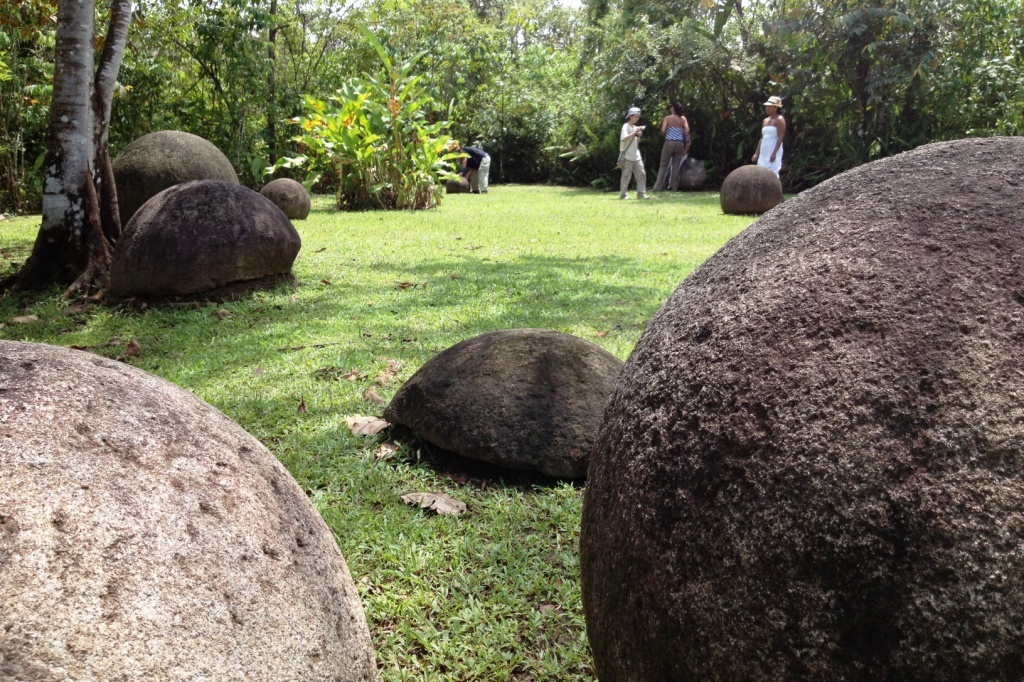
The property includes four archaeological sites located in the Diquís Delta in southern Costa Rica, which are considered unique examples of the complex social, economic and political systems of the period AD 500–1500. They contain artificial mounds, paved areas, burial sites and, most significantly, a collection of stone spheres, between 0.7 m and 2.57 m in diameter, whose meaning, use and production remain largely a mystery. The spheres are distinctive for their perfection, number, size and density, and placement in original locations. Their preservation from the looting that befell the vast majority of archaeological sites in Costa Rica has been attributed to the thick layers of sediment that kept them buried for centuries.
UNESCO Justification of the World Heritage Site
Criterion (iii): The Precolumbian Chiefdom Settlements with Stone Spheres of the Diquís illustrate the physical evidence of the complex political, social and productive structures of the Precolumbian hierarchical societies. The chiefdoms which inhabited the Diquís Delta created hierarchical settlements expressing the division of different levels of power centres, presented by the different serial components. Likewise, the exceptional stone spheres, which continue to leave researchers speculating about the method and tools of their production, represent an exceptional testimony to the artistic traditions and craft capabilities of these Precolumbian societies.
Encyclopedia Record: Stone spheres of Costa Rica
The stone spheres of Costa Rica are an assortment of over 300 petrospheres in Costa Rica, on the Diquís Delta and on Isla del Caño. Locally, they are also known as bolas de piedra. The spheres are commonly attributed to the extinct Diquís culture, and they are sometimes referred to as the Diquís spheres. They are the best-known stone sculptures of the Isthmo-Colombian area.Additional Site Details
Area: 24.73 hectares
Number of Components: 4
Coordinates: 8.938453 , -83.502539
Image
© Axxis10, CC BY-SA 3.0 Resized from original. (This derivative is under the same CC BY-SA license.)
