World Heritage Identification Number: 1582
World Heritage since: 2025
Category: Cultural Heritage
WHE Type: Buildings & Architectural Ensembles
Transboundary Heritage: No
Endangered Heritage: No
Country: 🇵🇦 Panama
Continent: Americas
UNESCO World Region: Latin America and the Caribbean
Map
The Colonial Transisthmian Route of Panamá: A Strategic Network Connecting Continents
The Colonial Transisthmian Route of Panamá, inscribed as a UNESCO World Heritage Site in 2025, offers a fascinating glimpse into the historical, cultural, and architectural legacy of one of the most strategically important regions in the world during the colonial era. This extensive network of roads, fortifications, and settlements spanning over six distinct areas played a crucial role in connecting the Atlantic and Pacific Oceans from the 16th to the 19th centuries.
More to come…UNESCO Description of the World Heritage Site
From the 16th century, the isthmus of Panama became a global strategic asset facilitating the transportation of goods and people between the Iberian Peninsula and the colonies of the Kingdom of Spain in America, the archipelago of the Philippines and the Canary Islands. The serial property bears testimony of the crossing of the isthmus including strategic fortified settlements, historic towns, archaeological sites and roads used to connect the Caribbean Sea and the Pacific Ocean until the mid-18th century.
UNESCO Justification of the World Heritage Site
Criterion (ii): The Colonial Transisthmian Route of Panamá, constructed as part of the process of colonisation of the Americas, played a significant role in the establishment of a global communication system that facilitated the exchange of goods between the Iberian Peninsula and the colonies of the Kingdom of Spain in South and North America, the archipelago of the Philippines and the Canary Islands. This process resulted in the interchange of ideas, skills, and traditions between different populations, including Indigenous Peoples, enslaved Africans and European colonisers. This process, which was not a peaceful one, lasted over three centuries and was centred on the expansion of the hegemony of the Kingdom of Spain, which strongly influenced and marked the history and further development of the Americas.
Criterion (iv): The Colonial Transisthmian Route of Panamá demonstrates an outstanding example of a route enabling transcontinental flows of culture, resources and colonial power during a crucial stage in the history of the Americas. The location of historic port cities, fortifications and roads reflects the emergence of a colonial territorial approach that adapted and made use of challenging climatic and geographic conditions, as well as, indigenous and local knowledge, for the development of a communication and commercial system which had global impacts.
Encyclopedia Record: The Colonial Transisthmian Route of Panamá
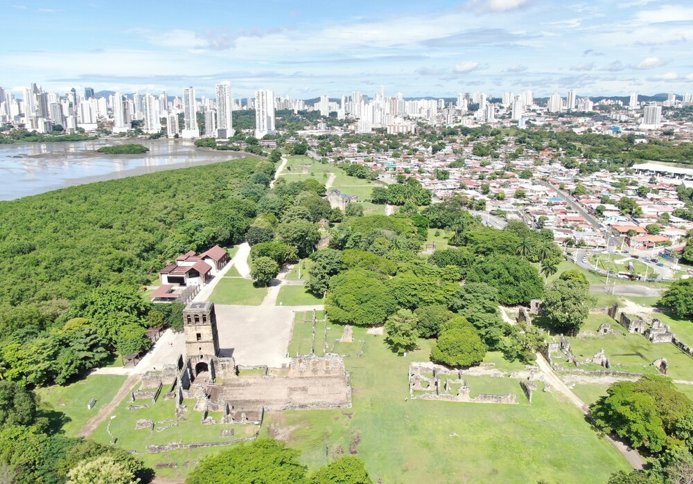
The Colonial Transisthmian Route of Panamá is a World Heritage Site located in Panama. It consists of six areas. Among them, Panama City and the fortifications of Portobelo and San Lorenzo are also part of the site inscribed on the World Heritage List in 1980. The other areas include the Camino de Cruces and the Camino Real. These routes formed part of the network of roads built by the Spanish between the 16th and 19th centuries to connect the Atlantic and Pacific Oceans.Additional Site Details
Area: 689.88 hectares
Number of Components: 6
(iv) — Outstanding example of a type of building or landscape
Coordinates: 9.3231722222 , -79.999775
Image
© MINISTERIO DE CULTURA. Used with permission.
