World Heritage Identification Number: 2
World Heritage since: 1978
Category: Cultural Heritage
WHE Type: Historic Cities & Urban Areas
Transboundary Heritage: No
Endangered Heritage: No
Country: 🇪🇨 Ecuador
Continent: Americas
UNESCO World Region: Latin America and the Caribbean
Map
A Glimpse into the Rich History and Architectural Wonders of the City of Quito
The City of Quito, officially known as San Francisco de Quito, serves as the capital and the second most populous city of Ecuador. Situated in a valley on the eastern slopes of the active stratovolcano Pichincha within the Andean region, this vibrant city boasts a rich history that dates back to pre-Columbian times.
More to come…UNESCO Description of the World Heritage Site
Quito, the capital of Ecuador, was founded in the 16th century on the ruins of an Inca city and stands at an altitude of 2,850 m. Despite the 1917 earthquake, the city has the best-preserved, least altered historic centre in Latin America. The monasteries of San Francisco and Santo Domingo, and the Church and Jesuit College of La Compañía, with their rich interiors, are pure examples of the 'Baroque school of Quito', which is a fusion of Spanish, Italian, Moorish, Flemish and indigenous art.
UNESCO Justification of the World Heritage Site
Criterion (ii): The influence of the Baroque school of Quito (Escuela Quitena) was recognized in the cultural domain, especially art – architecture, sculpture and painting – in all the cities of the Audencia, and even in those of the neighbouring Audencia.
Criterion (iv): Quito forms a harmonious sui generis where the actions of man and nature come together, to create a unique and transcendental work of its kind.
Encyclopedia Record: Quito
Quito, officially San Francisco de Quito, is the capital and second-largest city of Ecuador, with an estimated population of 2.8 million in its metropolitan area. It is also the capital of the province of Pichincha. Quito is in a valley on the eastern slopes of Pichincha, an active stratovolcano in the Andes.Additional Site Details
Area: 70.43 hectares
Number of Components: 1
(iv) — Outstanding example of a type of building or landscape
Coordinates: -0.22 , -78.5120833333
Image
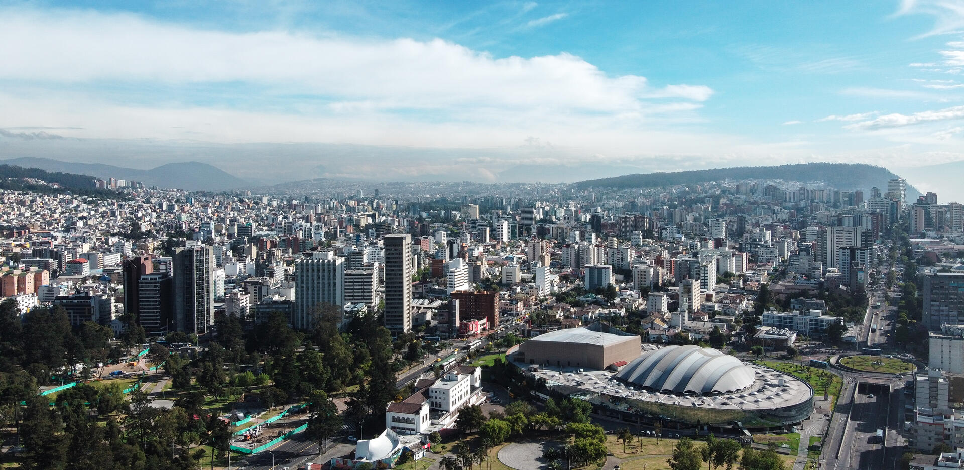
© Asamblea Nacional del Ecuador, CC BY-SA 2.0 Resized from original. (This derivative is under the same CC BY-SA license.)
World Heritage Research
Discover scientific research and academic studies that deepen our understanding of City of Quito from its history and significance to its conservation, management, and contemporary challenges.
-
Insecurity as An Influential Factor In The Tourism Development of the Historical Center of Quito
A significant perception of insecurity among tourists, driven by factors such as informal commerce, homelessness, micro-trafficking, and poor urban conditions, is hindering tourism development in Quito's Historic Center. This study identifies these social problems—unprecedented in Ecuador's capital—as critical barriers to progress. Using a mixed-methods approach, the research combined qualitative bibliographic analysis with quantitative surveys of tourists to systematically map these issues. The findings underscore the need for targeted strategies to address insecurity, offering actionable insights for urban planning and tourism management in UNESCO-listed sites facing similar challenges.
Belén, C. G. S., Mateo, V. G. R., Damián, A. P. J., Leonidas, V. A. J., & Andrés, T. A. J. (2025). Insecurity as An Influential Factor In The Tourism Development of the Historical Center of Quito. Revista de Gestão Social E Ambiental, 19(1), e011009. https://doi.org/10.24857/rgsa.v19n1-135
View Publication Record | Read Publication -
The Role of Gastronomy as a Cultural and Touristic Identity in Quito’s Historic Center
Quito's historic center, renowned for its exceptional preservation and cultural significance, leverages gastronomy as a pivotal element of its identity, attracting both domestic and international tourists. This study reveals that the city's culinary heritage, rooted in ancestral knowledge and diverse local products, plays a crucial role in shaping its tourist appeal. Through a bibliographic review, the research identifies key characteristics of Quito's gastronomic tourism, highlighting its integration with cultural, historical, and sensory elements. The findings underscore the need for diversification in both the tourist market and gastronomic offerings to further solidify Quito's position as a cultural reference point within Ecuador.
Quezada-Sarmiento, P. A., & Chango-Cañaveral, P. M. (2025). The Role of Gastronomy as a Cultural and Touristic Identity in Quito’s Historic Center. Journal of Posthumanism, 5(5). https://doi.org/10.63332/joph.v5i5.1804
View Publication Record | Read Publication -
Women’s Right to the City: The Case of Quito, Ecuador
A significant gender gap persists in Quito's urban design, with 81% of women experiencing sexual or offensive remarks and 69.8% encountering obscene gestures within a month, highlighting routine harassment that shapes their mobility and behavior. This study reveals how poorly lit corridors and weak institutional presence amplify violence against women, despite the city's 'Safe City' program. The research combines constitutional analysis, survey data (n=736), in-depth interviews, and participatory observation to demonstrate that Quito’s public spaces fail to uphold women’s right to safety and participation. The findings underscore the need for gender-sensitive urban planning, intersectoral resources, and substantive female involvement in policy-making to transform legal principles into lived realities.
Baca Calderón, M. C., Quattrone, G., Sánchez Borja, E., & Rocchio, D. (2025). Women’s Right to the City: The Case of Quito, Ecuador. Social Sciences, 14(8), 448. https://doi.org/10.3390/socsci14080448
View Publication Record | Read Publication -
Effects on Soil Organic Carbon Stock in the Context of Urban Expansion in the Andes: Quito City Case
Urban expansion significantly reduces soil organic carbon storage capacity by 66% when montane forests are replaced by Eucalyptus globulus plantations, highlighting the vulnerability of high-altitude ecosystems to urbanization. The study analyzed soil attributes—organic matter, density, texture, nitrogen, phosphorus, and pH—in a transitional forest fragment in Quito's Western Cordillera, comparing it with eucalyptus plantations and grasslands as intermediate land covers. Researchers identified 253 individuals across 18 species in the montane forest, noting significant variations in soil attributes linked to organic matter. The findings underscore the critical role of natural cover in maintaining ecosystem stability and carbon storage, advocating for urban planning strategies that prioritize conservation and restoration of peri-urban areas to mitigate climate change impacts.
Uvidia, K., Salazar-Cotugno, L., Molina, J. R., Fernandes Silva, G., & Bonilla-Bedoya, S. (2025). Effects on Soil Organic Carbon Stock in the Context of Urban Expansion in the Andes: Quito City Case. Forests, 16(9), 1409. https://doi.org/10.3390/f16091409
View Publication Record | Read Publication -
Central parks as air quality oases in the tropical Andean city of Quito
Central parks in Quito, Ecuador, serve as temporary air quality oases amid high levels of fine particulate matter (PM2.5), but their protective effect is limited to the park's interior. Research found hazardous PM2.5 concentrations on the edges of parks along busy avenues—frequented by pedestrians—highlighting short- and long-term health risks from traffic pollution in urban recreational spaces, particularly in cities of the global south. The study used the Normalized Difference Vegetation Index (NDVI) to model PM2.5 spatial distribution, successfully predicting concentrations in a smaller park, suggesting potential for broader urban applications. While promising, further validation is needed to ensure its effectiveness across diverse cityscapes.
Zalakeviciute, R., Bonilla Bedoya, S., Mejia Coronel, D., Bastidas, M., Buenano, A., & Diaz-Marquez, A. (2024). Central parks as air quality oases in the tropical Andean city of Quito. Atmospheric Environment: X, 21, 100239. https://doi.org/10.1016/j.aeaoa.2024.100239
View Publication Record | Read Publication -
Calculation of carbon sequestered through remote sensing in a metropolitan park in the city of Quito, Ecuador
Researchers have quantified the carbon sequestration potential of eucalyptus trees in Quito, Ecuador's Guangüiltagua Metropolitan Park, estimating that these trees store approximately 42,150 tons of CO₂. This finding was derived using a multi-phase approach combining remote sensing and field measurements. The study employed the Normalized Differential Vegetation Index (NDVI) from Landsat 8 and Sentinel-2 satellite imagery to assess vegetation health and biomass over time. Field data, including diameter at breast height (DBH) and tree height, were collected across 50 quadrants to validate and refine these estimates. Linear regression models then extrapolated the CO₂ storage per quadrant to the entire park area. This work provides critical data for urban carbon inventory initiatives, offering a scalable method for assessing carbon sequestration in metropolitan green spaces.
Crespo Nuñez, X. L., Monge Amores, L. E., Sancho Zurita, J. V., & Vega Hernandez, O. (2024). Calculation of carbon sequestered through remote sensing in a metropolitan park in the city of Quito, Ecuador. Sapienza: International Journal of Interdisciplinary Studies, 5(1), e24021. https://doi.org/10.51798/sijis.v5i1.743
View Publication Record | Read Publication -
Ethnobotany resources from Metropolitan Parks of Quito city
A study of Quito's metropolitan parks identified 92 ethnobotanically valuable plant species, with 68% being native Andean and 3.3% endemic. These plants hold significant medicinal, nutritional, ritual, and cosmetic uses, often tied to magical-religious practices. The research, conducted between March and July 2017, involved collecting and cataloging species in five parks under the guidance of traditional knowledge holders and complemented by a review of scientific literature. The findings highlight that urban areas can still preserve biodiversity, serving as small refuges that support health and well-being. This study underscores the importance of integrating ancestral knowledge with modern research to conserve and utilize these natural resources.
Noriega, P., Calderón, L., Taxo Taco, A., Montaluisa, M. B., Jaramillo, K., & Noriega, P. (2024). Ethnobotany resources from Metropolitan Parks of Quito city. Ethnobotany Research and Applications, 28. https://doi.org/10.32859/era.28.23.1-20
View Publication Record | Read Publication