World Heritage Identification Number: 1647
World Heritage since: 2021
Category: Cultural Heritage
WHE Type: Cultural Landscapes
Transboundary Heritage: No
Endangered Heritage: No
Country: 🇮🇷 Iran (Islamic Republic of)
Continent: Asia
UNESCO World Region: Asia and the Pacific
Map
The Cultural Landscape of Hawraman/Uramanat: A Millennial Testimony of Traditional Kurdish Culture
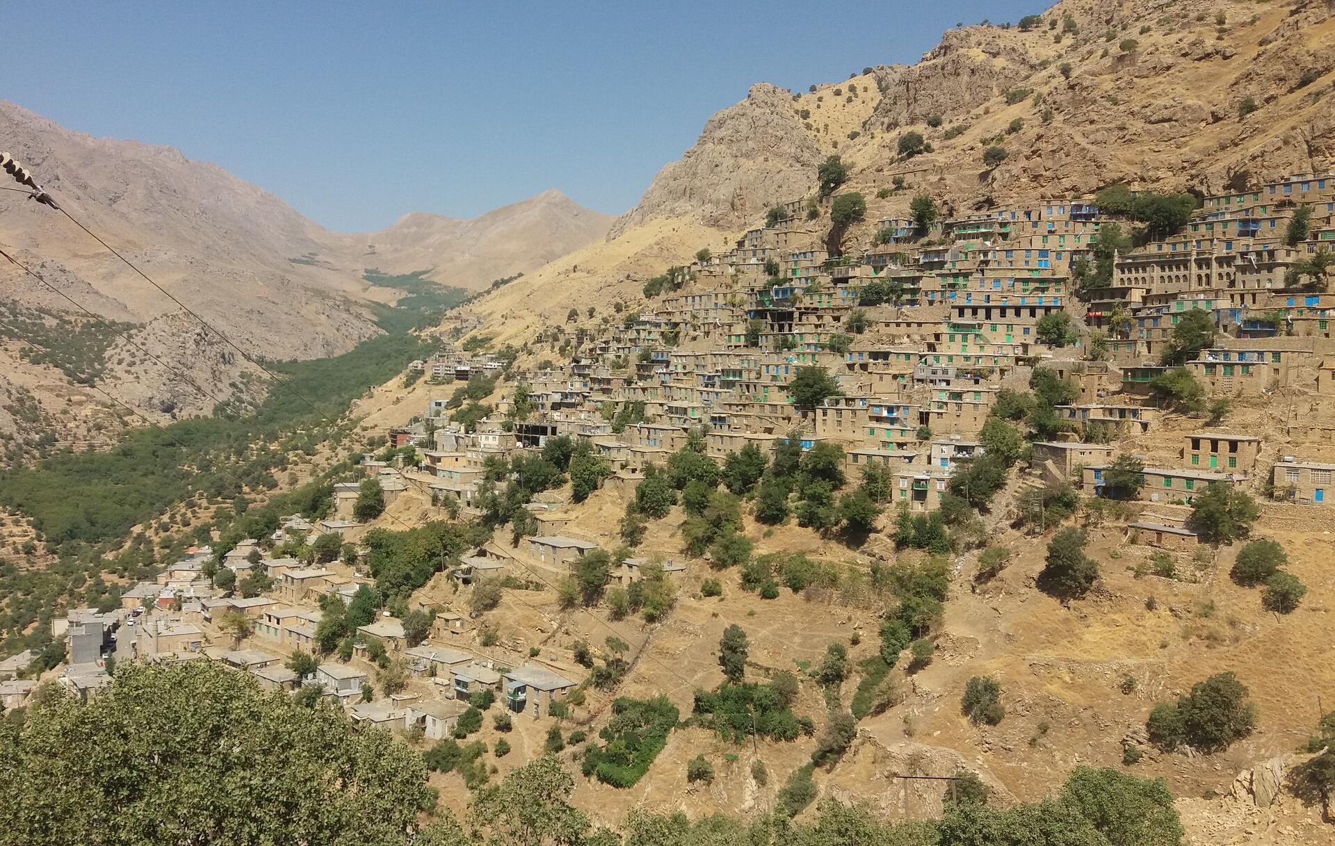
The Cultural Landscape of Hawraman/Uramanat, inscribed as a UNESCO World Heritage Site in 2021, offers a unique glimpse into the rich history and resilient culture of the Hawrami people, an agropastoral Kurdish tribe that has thrived in the rugged terrain of the Zagros Mountains for over four millennia. Located in the provinces of Kurdistan and Kermanshah along the western border of Iran, this remote and mountainous landscape serves as a testament to the ingenuity, adaptability, and tenacity of its inhabitants.
More to come…UNESCO Description of the World Heritage Site
The remote and mountainous landscape of Hawraman/Uramanat bears testimony to the traditional culture of the Hawrami people, an agropastoral Kurdish tribe that has inhabited the region since about 3000 BCE. The property, at the heart of the Zagros Mountains in the provinces of Kurdistan and Kermanshah along the western border of Iran, encompasses two components: the Central-Eastern Valley (Zhaverud and Takht, in Kurdistan Province); and the Western Valley (Lahun, in Kermanshah Province). The mode of human habitation in these two valleys has been adapted over millennia to the rough mountainous environment. Tiered steep-slope planning and architecture, gardening on dry-stone terraces, livestock breeding, and seasonal vertical migration are among the distinctive features of the local culture and life of the semi-nomadic Hawrami people who dwell in lowlands and highlands during different seasons of each year. Their uninterrupted presence in the landscape, which is also characterized by exceptional biodiversity and endemism, is evidenced by stone tools, caves and rock shelters, mounds, remnants of permanent and temporary settlement sites, and workshops, cemeteries, roads, villages, castles, and more. The 12 villages included in the property illustrate the Hawrami people’s evolving responses to the scarcity of productive land in their mountainous environment through the millennia.
UNESCO Justification of the World Heritage Site
Criterion (iii): The Cultural Landscape of Hawraman/ Uramanat bears exceptional testimony to the evolution over millennia of the traditional semi-nomadic agropastoral way of life of the Hawrami people. This cultural tradition is expressed in tangible and intangible elements of the landscape that have persisted up to the present day and continue to be the foundation of the local socio-economic system, including steep-slope terraced villages and gardens, transhumance routes, seasonal dwellings, and the traditional knowledge and practices associated with them. The property provides outstanding living testimony to various traditions that bear witness to a well-organized social, rural, semi-nomadic realm.
Criterion (v): The Cultural Landscape of Hawraman/Uramanat constitutes an outstanding example of human interaction with, and adaptation to, the surrounding environment. In the high Zagros Mountains, a challenging setting where there is little fertile soil, the Hawrami people, through a skillful application of agricultural technology and an enlightened ecological world view, have developed an extraordinary semi-nomadic agropastoral way of life. They have successfully created an efficient, harmonious, and sustainable socio-economic system.
Encyclopedia Record: Cultural Landscape of Uramanat
Cultural Landscape of Hawraman or Cultural Landscape of Uramanat is the 26th tangible cultural heritage of Iran. This remote and mountainous landscape bears testimony to the traditional culture of the Hawrami people, an agropastoral Kurdish tribe that has inhabited the region since about 3000 BCE. The property, at the heart of the Zagros Mountains in the provinces of Kurdistan and Kermanshah along the western border of Iran.Additional Site Details
Area: 106,307 hectares
Number of Components: 2
(v) — Outstanding example of traditional human settlement
Coordinates: 35.1073583333 , 46.47785
Image
© جواد یوسفی, CC BY-SA 4.0 Resized from original. (This derivative is under the same CC BY-SA license.)
