World Heritage Identification Number: 1371
World Heritage since: 2011
Category: Cultural Heritage
WHE Type: Cultural Landscapes
Transboundary Heritage: No
Endangered Heritage: No
Country: 🇪🇸 Spain
Continent: Europe
UNESCO World Region: Europe and North America
Map
The Cultural Landscape of the Serra de Tramuntana: A Unique Blend of Nature and Human Ingenuity
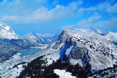
The Cultural Landscape of the Serra de Tramuntana, situated along the rugged northwestern coast of the Balearic Island of Mallorca, stands as a testament to human resilience and ingenuity in the face of challenging environmental conditions. This World Heritage Site, inscribed by UNESCO in 2011, offers a captivating blend of natural beauty and cultural heritage that continues to intrigue visitors from around the globe.
More to come…UNESCO Description of the World Heritage Site
The Cultural Landscape of the Serra de Tramuntana located on a sheer-sided mountain range parallel to the north-western coast of the island of Mallorca. Millennia of agriculture in an environment with scarce resources has transformed the terrain and displays an articulated network of devices for the management of water revolving around farming units of feudal origins. The landscape is marked by agricultural terraces and inter-connected water works - including water mills - as well as dry stone constructions and farms.
UNESCO Justification of the World Heritage Site
Criterion (ii): The landscape of the Serra de Tramuntana eminently exemplifies the interchange between the Muslim and Christian cultures, which is representative of the Mediterranean area, in the combination of the Arabic water harvesting and management technology with the agricultural know-how and the territorial control system introduced by the Christian conquerors, who took over the island of Mallorca in 13th century AD. By this cultural interaction, a terraced agricultural landscape was created, featured by an articulated waterworks network, orchards, vegetable gardens and olive groves, which were earlier organised around small farm holdings, and later in large estates (posesiones) and which nowadays make up the physical and functional features of the Serra de Tramuntana.
Criterion (iv): The cultural landscape of the Serra de Tramuntana represents a spectacular, peculiar example of a terraced. farmed landscape which combines an interconnected and highly specialised system of waterworks for collecting and storing water, featuring qanats, that are underground channels to harvest and transport water, canals, ditches, storage basins, with a system of terraces supported by dry-stone walls so as to make possible the cultivation of vegetables as well as fruit and olive trees in the terraced plots and including a sophisticated drainage system to avoid soil erosion.
Criterion (v): The settlement pattern of the Tramuntana area bears significant witness to human adaptation to difficult environmental conditions, which has ingeniously made a region with scarce resources, both in term of land and water, suitable for farming and living. The feudal land subdivision system, applied to extreme orographic conditions, combined with the sophisticated waterworks technology of Arabic origins has resulted in complex farming units. Their land distribution and use pattern, comprising rocky areas on the tops of mountains, strips of woodland, slopes with terraces, extensive grazing land, fields for reaping, vineyards or fruit crops on flatter land, ensured over time the full exploitation of the existing resources. The Tramuntana area thus pays testimony to the continuous evolution of human settlement in a rugged and steep area of the island.
Encyclopedia Record: Serra de Tramuntana
The Serra de Tramuntana is a mountain range running southwest–northeast which forms the northern backbone of the Spanish island of Mallorca. It is also the name given to the comarca of the same area. On 27 June 2011, the Tramuntana Range was awarded World Heritage Status by UNESCO as an area of great physical and cultural significance.Additional Site Details
Area: 30,745 hectares
Number of Components: 1
(iv) — Outstanding example of a type of building or landscape
(v) — Outstanding example of traditional human settlement
Coordinates: 39.7308333333 , 2.6947222222
Image
No machine-readable author provided. Cybertoni assumed (based on copyright claims)., Public domain
